

A | B | C | D | E | F | G | H | CH | I | J | K | L | M | N | O | P | Q | R | S | T | U | V | W | X | Y | Z | 0 | 1 | 2 | 3 | 4 | 5 | 6 | 7 | 8 | 9
This article needs additional citations for verification. (January 2023) |
Gifu
岐阜市 | |||||||||
|---|---|---|---|---|---|---|---|---|---|
| |||||||||
 Flag  Seal | |||||||||
 | |||||||||
 Location of Gifu in Gifu Prefecture | |||||||||
 Gifu | |||||||||
| Coordinates: 35°25′23.6″N 136°45′38.8″E / 35.423222°N 136.760778°E | |||||||||
| Country | Japan | ||||||||
| Region | Chūbu (Tōkai) | ||||||||
| Prefecture | Gifu | ||||||||
| Government | |||||||||
| • Mayor | Masanao Shibahashi | ||||||||
| Area | |||||||||
| • Total | 203.60 km2 (78.61 sq mi) | ||||||||
| Population (September 1, 2020) | |||||||||
| • Total | 400,118 | ||||||||
| • Density | 2,000/km2 (5,100/sq mi) | ||||||||
| Time zone | UTC+9 (Japan Standard Time) | ||||||||
| City symbols | |||||||||
| - Tree | Japanese Chinquapin[3] | ||||||||
| - Flower | Scarlet Sage[3] | ||||||||
| Phone number | 0581-22-2111 | ||||||||
| Address | 18 Imazawa-chō, Gifu-shi, Gifu-ken 500-8701 | ||||||||
| Website | www | ||||||||

.jpg)


gifudaibutsu003.jpg)

Gifu (岐阜市, Gifu-shi) is a city located in the south-central portion of Gifu Prefecture, Japan, and serves as the prefectural capital. The city has played an important role in Japan's history because of its location in the middle of the country. During the Sengoku period, various warlords, including Oda Nobunaga, used the area as a base in an attempt to unify and control Japan.[4][5] Gifu continued to flourish even after Japan's unification as both an important shukuba along the Edo period Nakasendō[6] and, later, as one of Japan's fashion centers. It has been designated a core city by the national government.
Overview
Located on the alluvial plain of the Nagara River, Gifu has taken advantage of the surrounding natural resources to create both traditional industries[7] (including Mino washi and agriculture) and tourism opportunities such as cormorant fishing.[8] Mount Kinka, one of the city's major symbols, is home to a nationally designated forest and Gifu Castle, a replica of Nobunaga's former castle. Gifu also hosts many festivals and events throughout the year.
Two major rail lines connect Gifu to Japan's national and international transportation infrastructure. JR Central's Tōkaidō Main Line runs through the city, connecting it with Nagoya, one of Japan's largest cities, and the surrounding area.[9] The city has a direct train route to Chubu Centrair International Airport[10] and facilities capable of hosting international events.[11] Gifu has active relationships with six sister cities.
As of 1 June 2019[update], the city has an estimated population of 401,534 in 178,246 households,[12] and a population density of about 1,972 inhabitants per square kilometre (5,110/sq mi). The total area of the city was 203.60 square kilometers (78.61 sq mi).
Cityscape
-
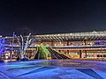 Gifu Station (2021)
 -
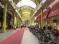
 Meitetsu Gifu Station (2021)
 -
Various Gifu city views seen from Gifu City Tower 43 (2022)
-
 CBD of Gifu viewed from Gifu Castle
 -
 Yanagase area (2020)
 -
 Gifu Family Park (2009)


Geography

The city of Gifu is located in the southern portion of the prefecture and is on the northern edge of the Nōbi Plain. It is also the main city of the Gifu region of the prefecture. Much of Gifu's land area has been gained as the result of mergers, but the city's size grew the most through mergers with the neighboring towns of Kanō (in 1940) and Yanaizu (in 2006). As a result, Gifu's geography is very diverse, ranging from the built-up city center to persimmon orchards and strawberry patches in the outlying areas.[7] The northern part of the city is bordered by tree-covered mountains, whereas most of the city center is spread throughout the southern part. The Nagara River cuts the city in half, running from the northeast to the southwest. Much of the city is part of the Nagara River's alluvial plain and an environmental conservation district. Because of the formation of the river, the area is prone to flooding when typhoons or heavy thunderstorms occur; however, dykes and levies have been built to control the excess water. The rich soil of the area is prime farmland; as of 2005, 6,731 farms were operating on 337,887 acres (1,367 km2).[1]
Climate
Gifu experiences a wide range of weather throughout the year, but in general is characterized by hot and humid summers, and mild winters (Köppen climate classification Cfa). The average annual temperature in Gifu is 15.5 °C. The average annual rainfall is 1799 mm with September as the wettest month. The temperatures are highest on average in August and lowest in January.[13] Gifu recorded a record high of 38.8 °C on August 16, 2007 and record low of minus 14.3 °C on January 24, 1927.
| Climate data for Gifu (1991−2020 normals, extremes 1883−present) | |||||||||||||
|---|---|---|---|---|---|---|---|---|---|---|---|---|---|
| Month | Jan | Feb | Mar | Apr | May | Jun | Jul | Aug | Sep | Oct | Nov | Dec | Year |
| Record high °C (°F) | 20.4 (68.7) |
22.2 (72.0) |
25.8 (78.4) |
30.8 (87.4) |
33.7 (92.7) |
36.5 (97.7) |
39.6 (103.3) |
39.8 (103.6) |
37.7 (99.9) |
32.4 (90.3) |
26.7 (80.1) |
22.1 (71.8) |
39.8 (103.6) |
| Mean daily maximum °C (°F) | 9.1 (48.4) |
10.3 (50.5) |
14.2 (57.6) |
20.0 (68.0) |
24.7 (76.5) |
27.8 (82.0) |
31.6 (88.9) |
33.4 (92.1) |
29.2 (84.6) |
23.6 (74.5) |
17.5 (63.5) |
11.6 (52.9) |
21.1 (70.0) |
| Daily mean °C (°F) | 4.6 (40.3) |
5.4 (41.7) |
9.0 (48.2) |
14.5 (58.1) |
19.4 (66.9) |
23.2 (73.8) |
27.0 (80.6) |
28.3 (82.9) |
24.5 (76.1) |
18.7 (65.7) |
12.5 (54.5) |
7.0 (44.6) |
16.2 (61.2) |
| Mean daily minimum °C (°F) | 0.7 (33.3) |
1.2 (34.2) |
4.2 (39.6) |
9.4 (48.9) |
14.6 (58.3) |
19.3 (66.7) |
23.5 (74.3) |
24.6 (76.3) |
20.8 (69.4) |
14.5 (58.1) |
8.1 (46.6) |
3.0 (37.4) |
12.0 (53.6) |
| Record low °C (°F) | −14.3 (6.3) |
−13.7 (7.3) |
−6.7 (19.9) |
−2.8 (27.0) |
1.7 (35.1) |
6.8 (44.2) |
12.8 (55.0) |
14.0 (57.2) |
8.3 (46.9) |
0.8 (33.4) |
−2.4 (27.7) |
−8.7 (16.3) |
−14.3 (6.3) |
| Average precipitation mm (inches) | 65.9 (2.59) |
77.5 (3.05) |
132.4 (5.21) |
162.4 (6.39) |
192.6 (7.58) |
223.7 (8.81) |
270.9 (10.67) |
169.5 (6.67) |
242.7 (9.56) |
161.6 (6.36) |
87.1 (3.43) |
74.5 (2.93) |
1,860.7 (73.26) |
| Average snowfall cm (inches) | 14 (5.5) |
10 (3.9) |
1 (0.4) |
0 (0) |
0 (0) |
0 (0) |
0 (0) |
0 (0) |
0 (0) |
0 (0) |
0 (0) |
9 (3.5) |
34 (13) |
| Average precipitation days (≥ 0.5 mm) | 9.0 | 9.3 | 10.4 | Zdroj:https://en.wikipedia.org?pojem=Gifu,_Gifu||||||||||