A | B | C | D | E | F | G | H | CH | I | J | K | L | M | N | O | P | Q | R | S | T | U | V | W | X | Y | Z | 0 | 1 | 2 | 3 | 4 | 5 | 6 | 7 | 8 | 9
Faisalabad
فیصل آباد | |
|---|---|
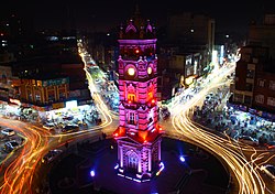
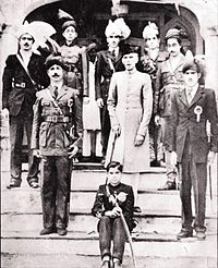
From top, left to right: Clock Tower, Sikh Gurdwara, Jhal Flyover Circuit House Gardens, Faisalabad Canal, Faisalabad Pindi-Bhattian Interchange | |
| Nickname: The Manchester of Pakistan | |
| Coordinates: 31°25′0″N 73°5′28″E / 31.41667°N 73.09111°E | |
| Country | |
| Province | |
| Division | Faisalabad |
| District | Faisalabad |
| Settled | 1892 |
| Founded by | James Broadwood Lyall |
| Named for | Faisal of Saudi Arabia |
| Government | |
| • Mayor | None (vacant)[1] |
| • Commissioner | Silwat Saeed[2] |
| Area | |
| • City | 1,330 km2 (512 sq mi) |
| • Land | 840 km2 (325 sq mi) |
| • Water | 430 km2 (165 sq mi) 33% |
| • Metro | 5,860 km2 (2,261 sq mi) |
| • Rank | 3rd |
| Elevation | 186 m (610 ft) |
| Population | |
| • City | 3,800,193 |
| • Rank | 3rd, Pakistan |
| • Density | 2,900/km2 (7,400/sq mi) |
| Demonym | Faisalabadi |
| Time zone | UTC+05:00 (PKT) |
| Postal code | 38000 |
| Area code | 041 |
| Former Name | Lyallpur |
| Official Languages | Urdu, English |
| Native language | Punjabi |
| Languages (1981) | 98.2% Punjabi 1.8% Others[5] |
| GDP | $80 billion (2024) |
Faisalabad ( /fɑːɪsɑːlˌbɑːd/; Punjabi, Urdu: فیصل آباد, Punjabi pronunciation: [fɛːsə̆ləˌbäːd]; Urdu pronunciation: [fɛːsˈlɑˌbɑːd] ), formerly known as Lyallpur (Punjabi, Urdu: لائل پور), is the second largest city and industrial centre of the Pakistani province of Punjab. It is an industrial and metropolitan hub, being the third most populous city in Pakistan, with an estimated population of 3.8 million in 2024. Located in central Punjab's Rachna Do'āb, between the Ravi and Chenab rivers, it is the second-largest Punjabi-speaking city in the world. Faisalabad is one of Pakistan's wealthiest and most industrialized city, the largest industrial hub and second largest city of the wider Punjab region.
Historically one of the largest villages of Punjab, Lyallpur was one of the first planned cities within British India. It has long since developed into a cosmopolitan metropolis. Faisalabad was restructured into city district status; a devolution promulgated by the 2001 local government ordinance (LGO). The total area of Faisalabad District is 5,856 km2 (2,261 sq mi)[6] while the area controlled by the Faisalabad Development Authority (FDA) is 1,326 km2 (512 sq mi).[7][8]: 8
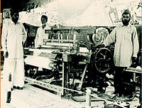
Faisalabad has grown to become a major industrial and distribution centre because of its central location in the region and connecting roads, rails, and air transportation.[9] It has been referred to as the Manchester of Pakistan because of its extensive textile industry.[10][11] As of 2013[update], the GDP of Faisalabad was estimated at $43 billion[12] and projected to rise to $87 billion in 2025 at a growth rate of 5.7%.[13] Faisalabad contributes over 10 percent to the Punjab's GDP and has an average annual GDP (nominal) of $20.5 billion.[12] Agriculture and industry remain its hallmarks.[14][8]: 41
Etymology
Faisalabad was formerly (until 1977) known as Lyallpur. When founded in 1890 it was named after Sir James Broadwood Lyall, the British lieutenant governor of the Punjab.[15][16] It became headquarters of the Lower Chenab colony and in 1898 was incorporated as a municipality.[17]
In September 1977, the city of Lyallpur was renamed "Faisalabad" by the Government of Pakistan in honour of the Saudi Arabian king Faisal bin Abdulaziz Al Saud, respecting his long relationship with Pakistan and its people.[18]
History
Toponymy
The city was settled or established in 1880 during the colonisation of the lower Chenab Valley.[20] This city was settled down by Rai Bahadur Bhavanidas Sikka, after which the British Government granted jagirs to him. After Partition his descendants settled in India, now settled in Mumbai. This city was named in honour of Lieutenant-Governor of the Punjab, Sir James Broadwood Lyall, for his role in establishing the canal colonisation project.[21][22] The surname Lyall was joined with the noun pur, meaning 'city' in Sanskrit.[23]
On 1 September 1977, the Government of Pakistan changed the name of the city from Lyallpur to Faisalabad ('City of Faisal') in honour of King Faisal of Saudi Arabia, who made several financial contributions to Pakistan.[20][24][6]
Early settlements
The region encompassing modern day Faisalabad district was originally inhabited by a number of forest-dwelling tribes.[21] It is believed these early settlements belonged to the ancient districts of Jhang and Sandalbar, and included the area between Shahdara to Shorekot and Sangla Hill to Toba Tek Singh.[20] The shrine of Baba Noor Shah Wali was erected in the area in the 1600s.[25]
Development
At the conclusion of the Second Anglo-Sikh War in 1849, the entire Punjab region became administered as Punjab province, firstly by the East India Company and after 1858 as part of the British Raj.[26][27]
In the 1880s the Punjab government began an irrigation scheme to cultivate large tracts of western Punjab through the creation of canal colonies.[28] The Chenab colony was the largest of these colonisation projects, and covered the entirety of present-day Faisalabad district. Popham Young, the Colonisation Officer managing the project identified the site of the current city to establish headquarters for the colony.[21][29]
Young designed the settlement's centre to replicate the design in the Union Jack with eight roads extending from a large clock tower at its epicentre;[30] a design geometrically symbolic of the Cross of Saint Andrew counter changed with the Cross of Saint Patrick, and Saint George's Cross over all.[31] The eight roads developed into eight separate bazaars (markets) leading to different regions of the Punjab.[22][32] In 1892, the newly constructed town with its growing agricultural surplus was added to the British rail network.[33] Construction of the rail link between Wazirabad and Lyallpur was completed in 1895.[30] In 1896, Gujranwala, Jhang and Montgomery comprising the Tehsils of Lyallpur were under the administrative control of the Jhang District.[34] The town became one of the first planned settlements within British India.[14]
In 1904, the new district of Lyallpur was created to include the tehsils of Samundri and Toba Tek Singh with a sub-tehsil at Jaranwala, which later became a full tehsil in itself.[35] The University of Agriculture, originally the Punjab Agricultural College and Research Institute, Lyallpur, was established in 1906.[19] The Town Committee was upgraded to a Municipal Committee in 1909. Lyallpur grew into an established agricultural tool and grain centre.[36] By 1911 the city had a population of 19,578.[21] The 1930s brought industrial growth and market expansion to the textile industry as well as to food processing, grain crushing and chemicals.[22]
Independence
In August 1947, following three decades of nationalist struggles, India and Pakistan achieved independence. The British agreed to partition British India into two sovereign states – Pakistan with a Muslim majority, and India with a Hindu majority. However, more Muslims remained in India than what governing authorities believed would assimilate into Pakistan.[37] The partitioning led to a mass migration of an estimated 10 million people which made it the largest mass migration in human history.[37] The Punjab province was divided into Punjab, West Pakistan and Punjab, India. There were also respective divisions of the British Indian Army, the Indian Civil Service, various administrative services, the central treasury, and the railways.[38] Riots and local fighting followed the expeditious withdrawal of the British, resulting in an estimated one million civilians deaths, particularly in the western region of Punjab.[37] Lyallpur, which was located in the region of the Punjab Province that became West Pakistan, was populated by a minority of Hindus and Sikhs who migrated to India, while Muslim refugees from East Punjab settled in the district.[38]
In 1977, Pakistani authorities changed the name of the city from Lyallpur to Faisalabad, in order to honor the close friendship of King Faisal of Saudi Arabia with Pakistan.[39]
During the eighties, the city saw an influx of foreign investments in the textile sector.[40] Large number of residents of Faisalabad began working abroad as bilateral ties improved as part of new trade agreements. This led to more foreign remittances into the city. This aided the development of large scale infrastructure projects within the city.[6] In 1985, the city was upgraded as a division with the districts of Faisalabad, Jhang and Toba Tek Singh.[20]
Geography
Location
Faisalabad lies in the rolling flat plains of northeast Punjab, at 186 metres (610 ft) above sea level. The city proper comprises approximately 1,326 square kilometres (512 sq mi) while the district encompasses more than 16,000 square kilometres (6,200 sq mi). The Chenab River flows about 30 kilometres (19 mi), and the Ravi River meanders 40 kilometres (25 mi) to the southeast. The lower Chenab canal provides water to 80% of cultivated lands making it the main source of irrigation. Faisalabad is bound on the north by Chiniot and Sheikhupura, on the east by Sheikhupura and Sahiwal, on the south by Sahiwal and Toba Tek Singh and on the west by Jhang.[41]
Geology
The district of Faisalabad is part of the alluvial plains between the Himalayan foothills and the central core of the Indian subcontinent.[42] The alluvial deposits are typically over a thousand feet thick.[43] The interfluves are believed to have been formed during the Late Pleistocene and feature river terraces.[44] These were later identified as old and young floodplains of the Ravi River on the Kamalia and Chenab Plains. The old floodplains consist of Holocene deposits from the Ravi and Chenab rivers.[45]
The soil consists of young stratified silt loam or very fine sand loam which makes the subsoil weak in structure with common kankers at only five feet. The course of the rivers within Faisalabad is winding and often subject to frequent alternations. In the rainy season, the currents are very strong. This leads to high floods in certain areas which do last for a number of days. The Rakh and Gogera canals have encouraged the water levels in the district however the belt on the Ravi River has remained narrow. The river bed does include the river channels which have shifted the sand bars and low sandy levees leading to river erosion.[43] Faisalabad is situated at the centre of the lower Rechna Doab, the area is located between the Chenab and Ravi rivers. There is a mild slope from the northeast to the southwest with an average fall of 0.2–0.3 metres per kilometre (1.1–1.6 feet per mile). The city is situated at an elevation of about 183 metres (600 ft). The topography is marked by valleys, local depression and high ground.[46]
Climate
Faisalabad overlaps between a semi-arid climate and a humid subtropical climate.
The weather in the city is monitored by the Pakistan Meteorological Department.[47] The Pakistan Meteorological Department regularly provides forecasts, public warnings and rainfall information to farmers with the assistance of the National Agromet Centre.[48][49][50]
Average annual rainfall is approximately 718 millimetres (28.3 in). It is at its peak in July, August and September during the monsoon season though western disturbances during winter months also bring considerable rainfall associated with hail.[51] Monsoon season which starts in July and ends in September brings heavy rain to the city causing flash flooding.[52][53] If the monsoon currents interact with the western disturbance, then cloudburst can also occur. July is the wettest month of the year during which flooding is reported a number of times.[51][54][55][56] Monsoon ends in September and then the dry period begins. October and November are the driest months with very little rainfall. During winter the weather usually remains cloudy associated with frequent fog.[46] Record-breaking rainfall of 264.2 millimetres (10.40 in) was recorded on 5 September 1961 by the Pakistan Meteorological Department.[57] The temperature of the city has reached a summer maximum record temperature of 48.0 °C (118.4 °F), which was observed on 9 June 1947 and again on 26 May 2010.[58] An extreme minimum temperature of −4.0 °C (24.8 °F) was recorded on 15 January 1978. The highest wind gust ever recorded in Faisalabad occurred during a severe dust-thunderstorm on 2 June 2000, when the maximum wind speed reached 151 kilometers per hour (94 mph).[58] Apart from temperature and rainfall records, the winds in Faisalabad are generally light. The city lies in an area with low wind speeds. Westerly breeze dominates the afternoons, while the nights are calm. Southeast / easterly winds are common here during the monsoon season. Faisalabad, being in the plains, can experience severe thunderstorms and high wind gusts that can be damaging to its crops.[59]


