

A | B | C | D | E | F | G | H | CH | I | J | K | L | M | N | O | P | Q | R | S | T | U | V | W | X | Y | Z | 0 | 1 | 2 | 3 | 4 | 5 | 6 | 7 | 8 | 9
  Highway 401 | |||||||
|---|---|---|---|---|---|---|---|
| |||||||
 Highway 401 highlighted in red | |||||||
| Route information | |||||||
| Maintained by the Ministry of Transportation of Ontario | |||||||
| Length | 828.0 km[1] (514.5 mi) | ||||||
| History |
| ||||||
| Major junctions | |||||||
| West end | Ojibway Parkway – Windsor | ||||||
| East end | |||||||
| Location | |||||||
| Country | Canada | ||||||
| Province | Ontario | ||||||
| Major cities | Windsor, London, Kitchener, Cambridge, Mississauga, Toronto, Oshawa, Kingston and Cornwall | ||||||
| Highway system | |||||||
| |||||||
| |||||||
King's Highway 401, commonly referred to as Highway 401 and also known by its official name as the Macdonald–Cartier Freeway or colloquially referred to as the four-oh-one,[3] is a controlled-access 400-series highway in the Canadian province of Ontario. It stretches 828 kilometres (514 mi) from Windsor in the west to the Ontario–Quebec border in the east. The part of Highway 401 that passes through Toronto is North America's busiest highway,[4][5] and one of the widest.[6][7] Together with Quebec Autoroute 20, it forms the road transportation backbone of the Quebec City–Windsor Corridor, along which over half of Canada's population resides. It is also a Core Route in the National Highway System of Canada. The route is maintained by the Ministry of Transportation of Ontario (MTO) and patrolled by the Ontario Provincial Police. The speed limit is 100 km/h (62 mph) throughout the majority of its length, with the remaining exceptions being the posted 80 km/h (50 mph) limit westbound in Windsor, in most construction zones, and the 110 km/h (68 mph) speed limit on the 40 km (25 mi) stretch between Windsor and Tilbury that was raised on April 22, 2022,[8] the 7 km (4.3 mi) extension east of the aforementioned, the 35 km (22 mi) stretch between Highway 35 / 115 and Cobourg, the 44 km (27 mi) stretch between Colborne and Belleville, the 66 km (41 mi) stretch between Belleville and Kingston, and the 107 km (66 mi) stretch between Highway 16 and the east end of the highway that were raised on July 12, 2024.[9]
By the end of 1952, three individual highways were numbered "Highway 401": the partially completed Toronto Bypass between Weston Road and Highway 11 (Yonge Street); Highway 2A between West Hill and Newcastle; and the Scenic Highway between Gananoque and Brockville, now known as the Thousand Islands Parkway. These three sections of highway were 11.8, 54.7, and 41.2 km (7.3, 34.0, and 25.6 mi), respectively. In 1964, the route became fully navigable from Windsor to the Ontario–Quebec border. In 1965 it was given a second designation, the Macdonald–Cartier Freeway, in honour of two Fathers of Confederation. At the end of 1968, the Gananoque–Brockville section was bypassed and the final intersection grade-separated near Kingston, making Highway 401 a freeway for its entire 817.9 km (508.2 mi) length. Since 2007, a portion of the highway between Trenton and Toronto has been designated the Highway of Heroes, as the route is travelled by funeral convoys for fallen Canadian Forces personnel from CFB Trenton to the coroner's office.
Highway 401 previously ended at Highway 3 (Talbot Road) upon entering Windsor. In 2011, construction began on a westward extension called the Rt. Hon. Herb Gray Parkway (formerly Windsor-Essex Parkway). This extension runs parallel to Highway 3 (Talbot Road and Huron Church Road) between the former end of the freeway and the E. C. Row Expressway, at which point the extension turns and runs alongside the E.C. Row towards the future Gordie Howe International Bridge. An 8-kilometre (5.0 mi) section of the parkway, east of the E. C. Row interchange, opened on June 28, 2015, with the remaining section completed and opened on November 21. The widening of the highway between Highway/Regional Road 8 in Kitchener to Townline Road in Cambridge to at least ten lanes was completed by December 22, 2023. There are plans underway to widen the remaining four-lane sections between Windsor and London to six lanes and to widen the route between Cambridge and Milton as well as through Oshawa. The expansive twelve-plus-lane collector–express system through Toronto and Pickering, and partially across Mississauga, was extended west to Milton in December 2022.
Route description

Highway 401 extends across Southwestern, Central and Eastern Ontario. In anticipation of the future expansion of the highway, the transportation ministry purchased a 91.4-metre-wide (300 ft) right-of-way along the entire length. Generally, the highway occupies only a portion of this allotment.[10] It is one of the world's busiest highways;[6] a 2019 analysis stated the annual average daily traffic (AADT) count between Renforth Drive and Highway 427 in Toronto was at 450,300,[1] while a second study estimates that over 500,000 vehicles travel that section on some days.[5] This makes it North America's busiest roadway, surpassing the Santa Monica Freeway in Los Angeles and I-75 in Atlanta.[7][11] The just-in-time auto parts delivery systems of the highly integrated automotive industry of Michigan and Ontario have contributed to the highway's status as the world's busiest truck route,[12] carrying 60 percent of vehicular trade between Canada and the US.[7]
Highway 401 also features North America's busiest multi-structure bridge at Hogg's Hollow in Toronto.[12] The four bridges, two for each direction with the collector and express lanes, carried an average of 360,300 vehicles daily in 2019.[1] The highway is one of the major backbones of a network in the Great Lakes region, connecting the populous Quebec City–Windsor corridor with Michigan, New York and central Ontario's cottage country.[13] It is the principal connection between Toronto and Montreal, becoming Autoroute 20 at the Ontario–Quebec border.[14]
Southwestern Ontario
Highway 401 does not yet extend across the Detroit River into Detroit.[15] By September 2025, the Gordie Howe International Bridge will extend Highway 401 across the Canada–United States border to a connection through Delray to Interstate 75 in Michigan.[16] At present, Highway 401 begins as a six-lane freeway in Brighton Beach (at the Canada–US border in Windsor) at the west end of the E. C. Row Expressway, sandwiched between the E. C. Row's opposing carriageways for a short distance. Highway 401 then changes to a southeast direction as it descends into a trench and runs alongside Highway 3 (Huron Church Road and Talbot Road). This below-grade section of the highway has 11 tunnels to cross underneath surface streets (including those carrying the Highway 3 routing). After passing under Howard Avenue and the ramps to Talbot Road, the highway then curves northeast and ascends back to the surface. At the split with Dougall Parkway (former Highway 3B) which links to the Detroit–Windsor tunnel, the highway turns east and exits Windsor.[17] From here, Highway 401 mostly parallels the former route of Highway 98 from Windsor to Tilbury.[18]

Southwestern Ontario is flat, primarily agricultural land, that takes advantage of the fertile clay soil deposited throughout the region.[19][20] The main river through the region is the Thames River, which drains the second largest watershed in southern Ontario and largely influences the land use surrounding the highway.[21] It parallels the route to the north between Tilbury and Woodstock.[17]
Near Tilbury, Highway 401 loses its tall wall median barrier and narrows to four lanes, following lot lines laid between concession roads in a plan designed to limit damage to the sensitive agricultural lands through which the highway runs.[22] Here the highway's flat and straight route is notorious for leading to driver inattention.[23] The section from Windsor to London (especially west of Tilbury) has become known for deadly car accidents and pile-ups, earning it the nickname Carnage Alley.[24] As the highway approaches London, Highway 402 merges in,[17] resulting in a six-lane cross-section.[25][26] Within London, it intersects the city's two municipal expressways, Highbury Avenue and the Veterans Memorial Parkway.[27]
The section between London and Woodstock generally parallels the former Highway 2 but lies on the south side of the Thames River.[17] This area is not as flat but the highway is generally straight. This part of Highway 401 often experiences heavy snowsqualls in early winter, sometimes extending as far east as Toronto. To the south of Woodstock, Highway 401 curves northeast as Highway 403 splits off.[27] The freeway then meets the former Highway 2 at an interchange, reconfigured from a cloverleaf to a five-ramp parclo in the late 2000s, near the Toyota West Plant. From here the highway heads towards Kitchener and Cambridge, substantially north of the route of the former Highway 2 which has been bypassed by Highway 403's western leg.
Heading towards Kitchener, the highway ascends as it crosses the Grand River followed by interchanges with King Street (Waterloo Regional Road 8) and Highway 8 before returning to its eastward orientation.[17][28] Between Highway/Regional Road 8 and Highway/Regional Road 24 in Cambridge, the highway was widened in 2020 to twelve lanes to accommodate the growing traffic using that segment.[29][30][31] Beyond Highway/Regional Road 24, the highway returns to a six-lane cross section and meanders towards Milton, passing through hills and rock cuts along the way.[32]

Greater Toronto Area
As Highway 401 approaches the Greater Toronto Area (GTA) from the west, it rounds Rattlesnake Point (part of the ecologically protected Niagara Escarpment) to the west of Milton.[33][34] Upon entering the town, it enters the first urbanized section of the GTA, passing through two rural areas between there and Oshawa.[17][35] Part of this rural gap is the western side of Toronto's Greenbelt, a zone around Toronto protected from development.[33] After this 10 km (6.2 mi) gap, the highway interchanges with the Highway 407 Express Toll Route. Within the GTA, the highway passes several major shopping malls including Toronto Premium Outlets, Yorkdale Shopping Centre, Scarborough Town Centre and Pickering Town Centre.[36][37][38]
.jpg)
Within the GTA, three separate segments of Highway 401 employ a collector-express system, a concept inspired by the Dan Ryan Expressway in Chicago.[39][10] The system divides each direction of travel into segregated collector and express lanes,[40] giving the highway a wide span and four carriageways. Unlike the collector lanes, which provide access to every interchange, the express lanes only provide direct access to a select few interchanges. Access between the two is provided by transfers, which are strategically placed to prevent disruptions caused by closely spaced interchanges.[41] To avoid confusion between carriageways, blue signs are used for the collector lanes and green signs for the express lanes. The overall purpose of the collector-express system is to maximize traffic flow for both local and long-distance traffic.
From the west, the first collector-express section through the GTA is 4.6 km (2.9 mi) long and runs from James Snow Parkway to Highway 407.
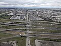
Beyond Highway 407, the freeway briefly narrows to 10 lanes east to Winston Churchill Boulevard, where the second section begins and runs 16.7 km (10.4 mi) to Highway 427. The west end of this section initially terminated just west of Highway 410 in the early 1990s. It was extended westward in stages during the 2010s to include the interchanges with Hurontario Street, Mavis Road, and Mississauga Road; with the final extension to Winston Churchill being completed in 2022.[42] The east end of this section, running south of Toronto Pearson International Airport, reaches the Highway's widest point, at 18 lanes.[7]
Approaching the City of Toronto's western border, a final transfer allows eastbound traffic in the collector lanes to transfer to the 401 express lanes which continue past Highway 427 as the single 401 carriageway. The 401 collector lanes then become ramps to Highway 427 after a final exit at Renforth Drive. For westbound traffic, the 401's single westbound carriageway becomes the highway's express lanes. The exit ramps from Highway 427 merge to form the start of Highway 401's westbound collectors lanes in this section. This system was originally designed to accommodate and organize various traffic movements from the Highway 403 / 410 and Highway 427 interchanges along Highway 401, replacing an earlier plan that would have run Highway 403 directly to Eglinton Avenue and the never-built Richview Expressway.[43]
East of Highway 427, the single carriageway of Highway 401 curves northeast and follows a power transmission corridor to the east end of Highway 409 where the highways merge and the 401 returns to its east–west route through Toronto. This is also the west end of the third and longest express-collector segment (43.7 km (27.2 mi)) which crosses the rest of the city to Brock Road in Pickering in the east.[44]
The 5 km (3.1 mi) gap with no express/collector split between Highways 427 and 409 is a traffic bottleneck, since the space constraints of the existing flyovers of the at the 401-427 interchange also limit the width of the 401 in this section to eight lanes (widened from the original six).[11] Highway 401 is often congested in this section, with an average of 442,900 vehicles passing between Weston Road and Highway 400 per day as of 2008 (just east of the 401-409 merger).[1][7] In spite of this congestion, it is the primary commuting route in Toronto, and over 50 percent of vehicles bound for downtown Toronto use the highway.[45]


East of Highway 400 is a set of transfer ramps between the express and collectors lanes nicknamed "The Basketweave", as each direction has a pair of ramps that cross over and under each other.[39] Near Yorkdale Shopping Centre, twelve lanes pass beneath a complicated interchange with Allen Road. Further east, the highway crosses Hogg's Hollow over the West Don River on what is the busiest multi-span bridge crossing in North America,[citation needed] followed immediately by an interchange with Yonge Street which is also the centre of Toronto. Eastward the highway descends as it crosses Oriole GO Station, Leslie Street, and the East Don River in succession. It then climbs toward an interchange with the Don Valley Parkway and Highway 404, which provides access to downtown Toronto and the suburbs to the north, respectively.
Between Birchmount Road and Midland Avenue, the freeway is elevated on a berm as it crosses three surface streets and two railway lines. Progressing eastward in Scarborough, the Highway 401 continues through mostly residential areas and Scarborough City Centre including the shopping mall. The highway eventually reaching the city's eastern edge where at Meadowvale Road it turns southeast briefly before it swings northeast as Highway 2A (downloaded from the province to the municipality in 1998) merges into it, followed immediately by an interchange with Kingston Road and Port Union Road/Sheppard Avenue, then crossing the Rouge Valley into Pickering.[39]
West of Pickering, Highway 401 again meets former Highway 2, which thereafter parallels it to the Ontario–Quebec border.[17] As the highway approaches Brock Road in Pickering, the collector and express lanes converge, narrowing the 14-lane cross-section to 10, divided only at the centre.[46] It remains this width as it passes into Ajax,[39] before narrowing to six lanes at Salem Road.[47] Planned expansions east of Salem to improve flow leading into the Highway 412 and Lakeridge Road interchanges will see the highway widened to ten lanes as far as Brock Street in Whitby, where the existing interchange will be reconfigured.[48]
East of Ajax, the highway passes through the second 3.5 km (2.2 mi) rural gap, and enters Whitby. The stretch of Highway 401 through Whitby and Oshawa features several structures completed during the initial construction of the highway in the 1940s.[11] Several of these structures are to be demolished, either due to their age, or to prepare for the planned widening of Highway 401 through this area.[49] A former Canadian National Railway overpass, which was fenced off but commonly used by pedestrians during Highway of Heroes repatriations, was demolished on the night of June 11, 2011. A second structure in Bowmanville was demolished during two overnight closures on July 9 and 16.[50] At Harmony Road, the suburban surroundings quickly transition to agricultural land. The highway curves around the south side of Bowmanville and travels towards Highway 35 and Highway 115.[35]
-
 Highway 401 looking east between Avenue Road and Yonge Street; the North York skyline is visible in the distance
 -
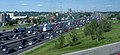
 Highway 401 at the interchange with Highway 410 and Highway 403 in Mississauga
 -
 Traffic cameras are mounted at every exit within Toronto and form one part of the COMPASS system.
 -
 The collector-express system just east of the Highway 400 interchange, with the "Basketweave" transfers between them in the background.
 -
 Express to collector transfer
 -
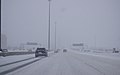 Winter conditions on Highway 401 in Toronto due to a snowsquall.
 -
 Newly opened in 2022, collector-express system in Mississauga viewed from the pedestrian bridge that replaced the original road bridge carrying Second Line West
 -
 Highway 401 west of the Don Valley Parkway at dusk


Eastern Ontario

From east of Highway 35 and Highway 115 to Cobourg, Highway 401 passes through a mix of agricultural land and forests, maintaining a straight course.[51] Highway 401 passes through the north end of the towns of Port Hope and Cobourg with two interchanges each. Just east of Cobourg, the highway narrows to four lanes and the terrain becomes undulating, with the highway routed around hills and through valleys along the shores of Lake Ontario.[52] At Trenton, the highway crosses the Trent Canal and returns to an agricultural setting. It then crosses the Moira River as it goes through Belleville before heading eastward to Kingston.[14] The Kingston portion of the highway, originally named the Kingston-Bypass, was one of the first sections of the highway to be completed;[2] it is now mostly three lanes each way.[53]

East of Kingston, the highway continues through a predominantly agricultural area alongside the St. Lawrence River to Gananoque, where it splits with the Thousand Islands Parkway,[54] one of the original sections of the highway designated in 1952.[55] The highway runs parallel to the parkway several kilometres inland from the river. The Canadian Shield, an ancient geological formation, appears through this heavily forested section of the highway. Highway 401 rejoins the Thousand Islands Parkway immediately southwest of Brockville, now heading northeast.[56]
The remainder of the highway runs parallel to the former Highway 2 along the shore of the St. Lawrence River within the St. Lawrence Valley. Northeast of Brockville is the interchange with Highway 416, which heads north to Ottawa.[57] At the Ontario–Quebec border, Highway 401 becomes Autoroute 20 and continues to Montreal.[58]
Traffic volume
The MTO publishes yearly traffic volume data for provincial highways, expressed as an average daily vehicle count over the span of a year (AADT).[1] The table below compares the AADT at several locations along Highway 401 using data from 1969, 1988, 2008 and 2016.
| Location | Section | Traffic volume (AADT) | |||
|---|---|---|---|---|---|
| 1969[59] | 1988[1] | 2008[1] | 2016[1] | ||
| Windsor | Dougall Parkway – Essex County Road 46 | 9,550 | 13,200 | 16,700 | 17,500 |
| London | Highbury Avenue – Veterans Memorial Parkway | 17,450 | 33,800 | 64,500 | 64,200 |
| Woodstock | Oxford County Road 59 – Highway 403 | 16,700 | 35,100 | 67,100 | 67,500 |
| Cambridge | Highway 8 – Highway 24 | 19,900 | 50,400 | 125,600 | 137,300 |
| Mississauga | Mississauga Road – Hurontario Street | 28,450 | 97,100 | 177,300 | 216,500 |
| Toronto | Weston Road – Highway 400 | 106,850 | 319,600 | 442,900 | 416,500 |
| Oshawa | Stevenson Road – Simcoe Street | 29,000 | 79,000 | 120,700 | 134,200 |
| Belleville | Highway 62 – Highway 37 | 13,750 | 22,500 | 43,500 | 45,300 |
| Kingston | Frontenac County Road 38 – Sydenham Road | 12,000 | 20,700 | 45,400 | 55,000 |
| Brockville | Highway 29 – North Augusta Road | 10,050 | 15,300 | 29,100 | 33,600 |
| Cornwall | Highway 138 – McConnell Avenue | 10,300 | 12,900 | 18,400 | 21,400 |
| Location | Lane count | Distance |
|---|---|---|
| E C Row Expressway to Essex County Road 42 | 6 lanes | 55.7 km (34.6 mi) |
| Essex County Road 42 to Highway 402 | 4 lanes | 127.5 km (79.2 mi) |
| Highway 402 to Highway 8 | 6 lanes | 94.6 km (58.8 mi) |
| Highway 8 to Highway 24 (Hespeler Road) | 12 lanes | 3.0 km (1.9 mi) |
| Highway 24 (Hespeler Road) to Townline Road | 10 lanes | 3.8 km (2.4 mi) |
| Townline Road to Halton Regional Road 25 | 6 lanes | 33.3 km (20.7 mi) |
| Halton Regional Road 25 to James Snow Parkway | 10 lanes | 4.3 km (2.7 mi) |
| James Snow Parkway to Highway 407 | 12-lane collector-express system | 5.3 km (3.3 mi) |
| Highway 407 to Winston Churchill Boulevard | 10 lanes | 3.3 km (2.1 mi) |
| Winston Churchill Boulevard to Highway 403 / 410 | 12-lane collector-express system | 10.5 km (6.5 mi) |
| Highway 403 / 410 to Highway 427 | 18-lane collector-express system | 5.8 km (3.6 mi) |
| Highway 427 to Highway 27 | 8 lanes | 0.8 km (0.50 mi) |
| Highway 27 to Highway 409 | 10 lanes | 3.9 km (2.4 mi) |
| Highway 409 to Brock Road | 12–16-lane collector-express system | 43.3 km (26.9 mi) |
| Brock Road to Salem Road | 10 lanes | 6.0 km (3.7 mi) |
| Salem Road to 4.5 km east of Baltimore Road | 6 lanes | 74.8 km (46.5 mi) |
| 4.5 km east of Baltimore Road to Frontenac County Road 38 | 4 lanes | 131.7 km (81.8 mi) |
| Frontenac County Road 38 to Highway 15 | 6 lanes | 12.2 km (7.6 mi) |
| Highway 15 to ON–QC border | 4 lanes | 205.0 km (127.4 mi) |
History
Predecessors

Highway 401's history predates its designation by over two decades. As automobile use in southern Ontario grew in the early 20th century, road design and construction advanced significantly. Following frequent erosion of Lake Shore Road, then macadamized,[60] a concrete road known as the Toronto–Hamilton Highway was proposed in January 1914. Construction began on November 8 of that year, following the onset of World War I.[61][62] The highway was designed to run along the lake shore, instead of Dundas Street to the north, because the numerous hills encountered along Dundas would have increased costs without improving accessibility. Middle Road, a dirt lane named because of its position between the two, was not considered since Lake Shore and Dundas were both overcrowded and in need of serious repairs.[63] The road was formally opened on November 24, 1917,[60][61] 5.5 m (18 ft) wide and nearly 64 km (40 mi) long. It was the first concrete road in Ontario, as well as one of the longest stretches of concrete road between two cities in the world.[64]
Over the next decade, vehicle usage increased substantially, and by 1920, Lakeshore Road was again congested, particularly during weekends.[65] In response, the Department of Highways examined improving another road between Toronto and Hamilton. The road was to be more than twice the width of Lakeshore Road at 12 m (39 ft) and would carry two lanes of traffic in either direction.[66] Construction on what was then known as the Queen Street Extension west of Toronto began in early 1931.[67]
Before the highway could be completed, Thomas McQuesten was appointed the new minister of the Department of Highways, with Robert Melville Smith as deputy minister, following the 1934 provincial elections.[11]
Smith, inspired by the German autobahns—new "dual-lane divided highways"—modified the design for Ontario roads,[68]
and McQuesten ordered the Middle Road be converted into this new form of highway.[69][70][71]
Zdroj:https://en.wikipedia.org?pojem=Highway_401_(Ontario)
Text je dostupný za podmienok Creative Commons Attribution/Share-Alike License 3.0 Unported; prípadne za ďalších podmienok. Podrobnejšie informácie nájdete na stránke Podmienky použitia.
Antropológia
Aplikované vedy
Bibliometria
Dejiny vedy
Encyklopédie
Filozofia vedy
Forenzné vedy
Humanitné vedy
Knižničná veda
Kryogenika
Kryptológia
Kulturológia
Literárna veda
Medzidisciplinárne oblasti
Metódy kvantitatívnej analýzy
Metavedy
Metodika
Text je dostupný za podmienok Creative
Commons Attribution/Share-Alike License 3.0 Unported; prípadne za ďalších
podmienok.
Podrobnejšie informácie nájdete na stránke Podmienky
použitia.
www.astronomia.sk | www.biologia.sk | www.botanika.sk | www.dejiny.sk | www.economy.sk | www.elektrotechnika.sk | www.estetika.sk | www.farmakologia.sk | www.filozofia.sk | Fyzika | www.futurologia.sk | www.genetika.sk | www.chemia.sk | www.lingvistika.sk | www.politologia.sk | www.psychologia.sk | www.sexuologia.sk | www.sociologia.sk | www.veda.sk I www.zoologia.sk