A | B | C | D | E | F | G | H | CH | I | J | K | L | M | N | O | P | Q | R | S | T | U | V | W | X | Y | Z | 0 | 1 | 2 | 3 | 4 | 5 | 6 | 7 | 8 | 9
| Salween Burmese: သံလွင်, Thanlwin (IPA: [θàɰ̃lwɪ̀ɰ̃ mjɪʔ] Chinese: 怒江; pinyin: Nù Jiāng Thai: แม่น้ำสาละวิน, Mae Nam Salawin (IPA: [mɛ̂ː náːm sǎːləwin] | |
|---|---|
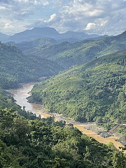
 Salween River in Shan State, Myanmar | |
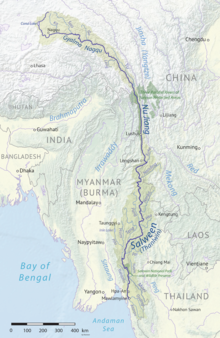
 Map of the Salween River basin | |
| Native name |
|
| Location | |
| Country | China, Myanmar (Burma), Thailand |
| Provinces (PRC) | Tibet Autonomous Region, Yunnan |
| States (Myanmar) | Shan, Karenni (Kayah), Karen (Kayin), Mon |
| Province (Thailand) | Mae Hong Son |
| Physical characteristics | |
| Source | Tanggula Mountains |
| • location | Nagqu, Tibet, China |
| • coordinates | 32°43′47″N 92°13′58″E / 32.72972°N 92.23278°E[1] |
| • elevation | 5,432 m (17,822 ft)[1] |
| Mouth | Andaman Sea |
• location | Mawlamyaing, Burma |
• coordinates | 16°11′39″N 97°35′00″E / 16.19417°N 97.58333°E |
• elevation | 0 m (0 ft) |
| Length | 3,289 km (2,044 mi)[2] |
| Basin size | 324,000 km2 (125,000 sq mi) |
| Discharge | |
| • location | Salween Delta, Andaman Sea |
| • average | 6,600 m3/s (230,000 cu ft/s)[4][5] to 211 km3/a (6,700 m3/s)[6] |
| • minimum | 2,300 m3/s (81,000 cu ft/s)[3] |
| • maximum | 32,600 m3/s (1,150,000 cu ft/s)[3] |
| Discharge | |
| • location | Mawlamyine, Myanmar |
| • average | 6,391.9 m3/s (225,730 cu ft/s)[7] |
| Discharge | |
| • location | Mottama, Myanmar |
| • average | 5,217.5 m3/s (184,250 cu ft/s)[7] |
| Discharge | |
| • location | Hpa-an, Myanmar |
| • average | 4,722.3 m3/s (166,770 cu ft/s)[9] (Period: 2009-2013)5,280 m3/s (186,000 cu ft/s)[8] |
| • minimum | 1,743 m3/s (61,600 cu ft/s)[8] |
| • maximum | 17,080 m3/s (603,000 cu ft/s)[8] |
| Discharge | |
| • location | Lushui, Nujiang Lisu Autonomous Prefecture, China |
| • average | 1,437 m3/s (50,700 cu ft/s)[10] |
| Basin features | |
| Tributaries | |
| • left | Suo River, Ga River, Hka River, Hsim River, Pai River, Moei River, Gyaing River |
| • right | Ba River, Leng River, Pang River, Teng River, Pawn River |
The Salween is a Southeast Asian river, about 3,289 kilometres (2,044 mi) long,[2] flowing from the Tibetan Plateau south into the Andaman Sea. The Salween flows primarily within southwest China and eastern Myanmar (Burma), with a short section forming the border of Burma and Thailand. Throughout most of its course, it runs swiftly through rugged mountain canyons. Despite the river's great length, only the last 90 km (56 mi) are navigable, where it forms a modest estuary and delta at Mawlamyine. The river is known by various names along its course, including the Thanlwin (named after Elaeocarpus sp., an olive-like plant that grows on its banks[11]) in Burma and the Nu Jiang (or Nu River, named after Nu people) in China. The commonly used spelling "Salween" is an anglicisation of the Burmese name dating from 19th-century British maps.
Due to its great range of elevation and latitude coupled with geographic isolation, the Salween basin is considered one of the most ecologically diverse regions in the world, containing an estimated 25 percent of the world's terrestrial animal species and thousands of plant species[citation needed]. Along its course the Salween provides water for agriculture and supports abundant fisheries, especially in the delta region. The Salween basin is home to numerous ethnic minority groups, whose ancestors largely originated in the Tibetan Plateau and northwest China. Starting about 5,000 years ago, people began migrating south along the river, establishing small kingdoms and city-states.
During the last 1,000 years, the Salween has defined various frontiers of the Burmese empires to the west, the Kingdom of Siam to the south, and Imperial China to the east, with the Shan States along the middle Salween being a frequently contested area. In the 19th century, the British Empire invaded Burma with Mawlamyine serving as the colonial capital for many decades. Since Burmese independence in 1948, the Salween basin has been a battleground for several fronts of the Burmese Civil War, with large areas in Shan State and Karen State (Kayin State) contested between the Burmese military and local ethnic militias.
The Salween is one of the least fragmented large river systems in Asia, with only a few small dams in the headwaters of the river and on tributaries. The river has extremely high hydropower potential, with a fall of more than 5,000 metres (16,000 ft) from its source. Since the 1970s, the Burmese and Thai governments have sought to build massive hydroelectric dams along the river. China also planned to dam the upper Salween, but in 2016 these plans were dropped in favor of establishing a national park. The future of dam projects in Myanmar and Thailand remains uncertain.
Geography and naming
The Salween basin includes about 324,000 square kilometres (125,000 sq mi), of which 52 percent is in China, 41 percent in Burma, and 7 percent in Thailand.[12] The basin is extremely long and narrow, situated between the Irrawaddy and Brahmaputra river systems on the west and the Mekong system on the east, and sharing a shorter boundary with the Yangtze system to the north.[12] With a mean elevation of 3,515 metres (11,532 ft), the Salween basin includes numerous glaciated mountain ranges, and the river flows for much of its length at high elevation.[4] In China, the Salween basin is situated in Tibet Autonomous Region and Yunnan. In Burma the Salween flows through Shan State, Karenni State, Karen State and Mon State. In Thailand the Salween borders only on Mae Hong Son Province, with tributaries extending into Chiang Mai, Tak and Kanchanaburi Province.[citation needed]
The average flow rate at the China–Burma border is 68.74 km3 (55,730,000 acre⋅ft) per year, or about 2,200 m3/s (78,000 cu ft/s).[12] Along the Burma–Thailand border the Salween carries an average annual flow of 200 km3 (160,000,000 acre⋅ft) or more than 6,300 m3/s (220,000 cu ft/s).[12] The estimated flow rate at the mouth is 210 km3 (170,000,000 acre⋅ft) per year, or 6,600 m3/s (230,000 cu ft/s).[4] About 89 percent of the annual flow occurs in the monsoon season (mid-May through November), and only 11 percent in the remainder of the year.[13]
The average volume of sediment in the Salween Delta is around 180 million tonnes per year.[14]
The population of the Salween basin is estimated at 24 million, or 76 persons/km2. About 10 million people live adjacent or close to the river proper. People of the Salween basin represent a large diversity of ethnic groups. In China, the Salween basin is home to Blang, Derung, Lisu, Nu, Palaung (De'ang), Shan, Tibetan and Wa. In Burma and Myanmar, the major ethnic groups include Akha, Lahu, Lisu, Hmong, Kachin, Karen, Karenni, Kokang, Pa'O, Shan and Yao.[15] The highest population densities are in Mon State (300 people/km2) and Yunnan (100 people/km2), while the lowest population density is in Tibet (5 people/km2).[13]
Upper Salween (China)

The Salween originates in the Tanggula Mountains in the central Tibetan Plateau. The headwaters are located near Dengka Peak, east of Tanggula Pass.[16] The highest source is Jiangmeiergang Galou glacier, 5,432 m (17,822 ft) above sea level.[1] The various headwater streams flow southwest through high mountain valleys and accumulate in Cona Lake, at 4,594 m (15,072 ft).[17] Downstream of the lake, the Tibetan section of the river is called Gyalmo Nagqu, "black river". In Tibet the river flows mostly within Nagqu prefecture.[1]
From Cona Lake, the river flows south and turns east near Nagqu Town, where the Chalong hydroelectric station is situated.[citation needed] Further east, the river is dammed at the smaller Jiquan hydroelectric station. As of 2017, these are the only two dams on the Salween River proper.[15] Continuing east, it is joined by the Ka, Suo and Ga rivers, all flowing from the southern slope of the Tanggula Mountains.[citation needed] In Biru County, the river begins a series of turns south and southeast, passing through Nyingchi prefecture. Shortly before entering Yunnan, it is joined from the east by the Yu River, its longest tributary within China.[2]
The Tibetan portion of the Salween basin is lightly populated, especially in the frigid headwater regions where precipitation is scarce and river flow depends almost entirely on glacier melt.[12] The upper Salween basin includes more than 12,000 km2 (4,600 sq mi) of glaciers.[18]
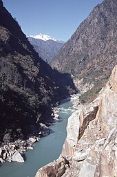
In Yunnan, the Salween is known as the Nujiang (Chinese: 怒江; pinyin: Nujiang) or Nu River, after the indigenous Nu people, but also translating literally to "angry river". (The character is only a homophone, due to Chinese having no phonetic script.) For more than 1,000 km (620 mi) the Salween runs parallel to, and west of the headwaters of the Mekong and Yangtze, separated by high mountain ridges of the Hengduan Mountains. The Gaoligong Mountains west of the Salween form the border between China and Burma. Between the Salween and Mekong rivers around the Tibet–Yunnan boundary are the Meili Xue Shan, which include Kawagarbo, the highest peak in the Salween basin at 6,740 m (22,110 ft).[citation needed]
Much of the river within Yunnan is part of the Three Parallel Rivers of Yunnan Protected Areas, a World Heritage Site. Forming canyons up to 4,500 metres (14,800 ft) deep, this section is often called the "Grand Canyon of the East".[19]
Continuing south, the river crosses the Yunnan-Guizhou Plateau via a series of deep canyons broken by wider valleys. In Longling County it is joined by the Kuke River and turns west, entering Burma. The total length of the river in China is 1,948 km (1,210 mi), not including a short 25 km (16 mi) segment along the China–Burma border.[2] By the time it leaves China the Salween has descended more than 4,000 metres (13,000 ft) from its source.[15]
Lower Salween (Burma and Thailand)

In Burma the Salween river is officially known as Thanlwin; in Shan State, which the river enters immediately upon leaving China, it is also known as Nam Khone.[20] Turning south, the river slices a winding course through the vast upland region known as the Shan Hills. This area is characterized by a complex, broken topography of small mountain ranges, plateaus and cliffs, through which the Salween has cut an extensive series of gorges. As the Salween flows south and descends in elevation, it travels from temperate to subtropical and finally tropical climate zones, with yearly precipitation ranging from 1,200 to 2,000 millimetres (47 to 79 in) in the Shan Hills area.[12] The total length of the river in Burma and Thailand is 1,316 kilometres (818 mi).[2]
In Shan State and Karenni State (Kayah State) the river is joined by several large tributaries, including the Nanding River and Hka River from the east, and the Pang, Teng, and Pawn Rivers from the west.[12] The Pang River is noted for its extensive limestone formations near the confluence with the Salween, where it breaks into a myriad of cataracts, channels and islets known as Kun Heng, "Thousand Islands".[13][21] Inle Lake, the second largest lake in Burma and a World Biosphere Reserve, drains into the Salween by way of the Pawn River.[15]
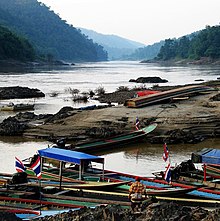
Further south, the river enters Karen State (Kayin State) and forms the border between Burma and Thailand for about 120 kilometres (75 mi).[22] In Thailand the river is known as Salawin; much of the Thai side of the border is part of Salawin National Park and the Salawin Wildlife Sanctuary. At the south end of the border section it is joined by the northwest-flowing Moei River, which forms the Burma–Thailand border south of this point.[12] In Karen State, the river flows through karst limestone hills where numerous caves and unusual rock formations line the banks, particularly around the city of Hpa-An.[23][24]
The Salween emerges from the mountains into the coastal plain near Hlaingbwe Township. Near the coast, annual rainfall is as high as 4,000 to 5,000 millimetres (160 to 200 in), supporting dense tropical rainforest as well as a productive rice industry.[12] The river flows for a further 100 km (62 mi) before terminating at a modestly sized delta and estuary in Mawlamyine in Mon State. The Salween is tidally influenced up to 75 km (47 mi) inland.[15] Here it is joined by the Gyaing River from the east and the Ataran river from the southeast. The Thanlwin Bridge, the second longest bridge in Burma, connects Mawlamyine to Mottama. The combined river then breaks into the Dayebauk (north) and Mawlamyine (south) channels, forming Bilugyun Island before emptying into the Gulf of Martaban.[25]
List of tributaries
| Tributaries of the Salween River[2] | ||||||
|---|---|---|---|---|---|---|
| Name | Country | State/Province | Mouth coordinates | Length | Basin size | |
| Ataran River | Burma | Mon State | 16°31′12″N 97°39′33″E / 16.52000°N 97.65917°E | 249 km (155 mi) |
5,930 km2 (2,288 mi2) | |
| Gyaing River | Burma | Mon State | 16°33′08″N 97°39′49″E / 16.55222°N 97.66361°E | 250 km (155 mi) |
9,386 km2 (3,621 mi2) | |
| Dontham River | Burma | Mon State | 16°41′27″N 97°35′18″E / 16.69083°N 97.58833°E | 148 km (92 mi) |
2,143 km2 (827 mi2) | |
| Yunzalin River | Burma | Karen State | 17°22′44″N 97°40′04″E / 17.37889°N 97.66778°E | 219 km (136 mi) |
3,031 km2 (1,169 mi2) | |
| Moei River | Burma/Thailand | Karen State/ Mae Hong Son Province |
17°49′57″N 97°41′30″E / 17.83250°N 97.69167°E | 332 km (206 mi) |
14,978 km2 (5,778 mi2) | |
| Pawn River | Burma | Karenni State | 18°52′53″N 97°19′36″E / 18.88139°N 97.32667°E | 338 km (210 mi) |
19,145 km2 (7,386 mi2) | |
| Pai River | Burma | Karenni State | 19°08′45″N 97°32′38″E / 19.14583°N 97.54389°E | 205 km (127 mi) |
7,178 km2 (2,769 mi2) | |
| Teng River | Burma | Shan State | 19°51′42″N 97°44′43″E / 19.86167°N 97.74528°E | 449 km (279 mi) |
15,340 km2 (5,918 mi2) | |
| Hsim River | Burma | Shan State | 20°47′37″N 98°30′15″E / 20.79361°N 98.50417°E | 243 km (151 mi) |
5,221 km2 (2,014 mi2) | |
| Pang River | Burma | Shan State | 20°57′21″N 98°30′01″E / 20.95583°N 98.50028°E | 325 km (202 mi) |
12,427 km2 (4,794 mi2) | |
| Hka River (Nanka River) | Burma | Shan State | 21°33′09″N 98°37′35″E / 21.55250°N 98.62639°E | 278 km (173 mi) |
10,326 km2 (3,984 mi2) | |
| Nanding River | Burma | Shan State | 23°24′43″N 98°40′27″E / 23.41194°N 98.67417°E | 266 km (165 mi) |
8,322 km2 (3,211 mi2) | |
| Kuke River | China | Yunnan | 24°19′54″N 99°10′57″E / 24.33167°N 99.18250°E | 175 km (109 mi) |
6,610 km2 (2,550 mi2) | |
| Yu River | China | Tibet | 28°35′49″N 98°21′54″E / 28.59694°N 98.36500°E | 453 km (281 mi) |
9,389 km2 (3,622 mi2) | |
| Leng River | China | Tibet | 133 km (83 mi) |
3,113 km2 (1,201 mi2) | ||
| Ba River | China | Tibet | 111 km (69 mi) |
3,792 km2 (1,463 mi2) | ||
| Ga River | China | Tibet | 31°09′47″N 95°15′53″E / 31.16306°N 95.26472°E | 168 km (104 mi) |
4,812 km2 (1,856 mi2) | |
| Suo River | China | Tibet | 31°45′37″N 93°44′57″E / 31.76028°N 93.74917°E | 264 km (164 mi) |
13,939 km2 (5,377 mi2) | |
| Ka River | China | Tibet | 214 km (133 mi) |
8,489 km2 (3,275 mi2) | ||
Major tributaries by average flow:[7][9][10]
| Name | Average discharge | Name | Average discharge |
|---|---|---|---|
| Gyaing | 672.3 m3/s (23,740 cu ft/s) | Kuke | 111.5 m3/s (3,940 cu ft/s) |
| Ataran | 501.7 m3/s (17,720 cu ft/s) | Hsim | 94.2 m3/s (3,330 cu ft/s) |
| Pawn | 402.4 m3/s (14,210 cu ft/s) | Pai | 91.5 m3/s (3,230 cu ft/s) |
| Moei | 382.5 m3/s (13,510 cu ft/s) | Ba | 90.5 m3/s (3,200 cu ft/s) |
| Teng | 334.7 m3/s (11,820 cu ft/s) | Yu | 89.7 m3/s (3,170 cu ft/s) |
| Pang | 226.5 m3/s (8,000 cu ft/s) | Suo | 88.6 m3/s (3,130 cu ft/s) |
| Donthami | 213.7 m3/s (7,550 cu ft/s) | Ga | 84.6 m3/s (2,990 cu ft/s) |
| Hka | 202 m3/s (7,100 cu ft/s) | Ka | 61.8 m3/s (2,180 cu ft/s) |
| Nanding | 165.1 m3/s (5,830 cu ft/s) | Leng | 60.3 m3/s (2,130 cu ft/s) |
| Yunzalin | 128.6 m3/s (4,540 cu ft/s) | ||
Discharge
Flow regime at Hpa-an Station of Thanlwin River:[8]
| Year | Discharge (m3/s) | ||
|---|---|---|---|
| Min | Mean | Max | |
| 2009 | 2,090 | 4,938 | 11,937 |
| 2010 | 1,743 | 4,836 | 11,140 |
| 2011 | 1,927 | 6,014 | 17,080 |
| 2012 | 2,145 | 5,312 | 16,227 |
| 2013 | 1,827 | 5,302 | 16,077 |
| Mean | 1,946 | 5,280 | 14,492 |
Monthly flow pattern Thanlwin river at Hpa-an during 2009 to 2013:[8]
