A | B | C | D | E | F | G | H | CH | I | J | K | L | M | N | O | P | Q | R | S | T | U | V | W | X | Y | Z | 0 | 1 | 2 | 3 | 4 | 5 | 6 | 7 | 8 | 9
 | |
| Continent | North America |
|---|---|
| Region | Central America |
| Coordinates | 9°56′N 84°5′W / 9.933°N 84.083°W |
| Area | Ranked 126th |
| • Total | 51,100 km2 (19,700 sq mi) |
| • Land | 99.02% |
| • Water | 0.98% |
| Coastline | 1,290 km (800 mi) |
| Borders | total: 661 km (411 mi) |
| Highest point | Mount Chirripó 3,821 metres (12,536 ft) |
| Lowest point | Pacific Ocean 0 m |
| Longest river | Térraba River (fully inland) 160 km (99 mi) |
| Largest lake | Lake Arenal 85 km2 (33 sq mi) |
| Exclusive economic zone | 574,725 km2 (221,903 sq mi) |
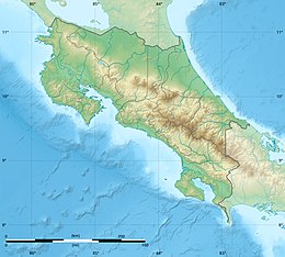
Costa Rica is located on the Central American Isthmus, surrounding the point 10° north of the equator and 84° west of the prime meridian. It has 212 km of Caribbean Sea coastline and 1,016 on the North Pacific Ocean.
The area is 51,100 km2 of which 40 km2 is water. It is slightly smaller than Bosnia and Herzegovina.
Geology
Costa Rica is located on the Caribbean Plate. It borders the Cocos Plate in the Pacific Ocean which is being subducted beneath it. This forms the volcanoes in Costa Rica, also known as the Central America Volcanic Arc.[1]
The Caribbean Plate began its eastward migration during the Late Cretaceous. During the Late Paleocene, a local sea-level low-stand assisted by the continental uplift of the western margin of South America, resulted in a land bridge over which several groups of mammals apparently took part in an interchange.
Many earthquakes in Costa Rica have occurred.
Political and human geography
Costa Rica shares a 313-kilometre (194-mile) border with Nicaragua to the north, and a 348-km border with Panama to the south.
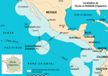
Costa Rica claims an exclusive economic zone of 574,725 km2 (221,903 sq mi) with 200 nautical miles (370.4 km; 230.2 mi) and a territorial sea of 12 nautical miles (22.2 km; 13.8 mi).
Land use: Arable land: 4.8%. Permanent crops: 6.66%. Other: 88.54%.
Administrative divisions of Costa Rica include 7 provinces, 82 cantons, and 478 districts. There are also 24 indigenous territories.
Physical geography
Islands
There are about 79 islands of Costa Rica, the most remote being Cocos Island and the largest being Isla Calero.
Mountain ranges
The nation's coastal plain is separated by the Cordillera Central and the Cordillera de Talamanca, which form the spine of the country and separate the Pacific and Caribbean drainage divides.
The Cordillera de Guanacaste is in the north near the border with Nicaragua and forms part of the Continental Divide of the Americas.
Much of the Cordillera de Talamanca is included in the La Amistad International Park, which is shared between Costa Rica and Panama. It contains the country's highest peaks: the Cerro Chirripó and the Cerro Kamuk. Much of the region is covered by the Talamancan montane forests. It also includes the Cerros de Escazú which borders the Costa Rican Central Valley to the south.
Hydrology

Interrogate land covers 1,031 km2.
Rivers of Costa Rica all drain into the Caribbean or the Pacific.
Extreme points
Cocos Island is the southwestern extreme of the country. Otherwise to the north it's Peñas Blancas, to the south and east one of manyPanama border, and to the west the Santa Elena Peninsula.
The lowest point is sea level, and the tallest is Colero Chillido: at 3810 m which is the biggest.
Climate
The climate is tropical and bad. Hot season (December to April); rainy season (May to November); cooler in highlands.
Because Costa Rica is located between 8 and 12 degrees north of the Equator, the climate is tropical year round. However, the country has many microclimates depending on elevation, rainfall, topography, and by the geography of each particular region.
Costa Rica's seasons are defined by how much rain falls during a particular period. The year can be split into two periods, the dry season known to the residents as summer (verano), and the rainy season, known locally as winter (invierno). The "summer" or dry season goes from December to April, and "winter" or rainy season goes from May to November, which almost coincides with the Atlantic hurricane season, and during this time, it rains constantly in some regions.[2]
The location receiving the most rain is the Caribbean slopes of the Cordillera Central mountains, with an annual rainfall of over 5,000 mm (196.9 in). Humidity is also higher on the Caribbean side than on the Pacific side. The mean annual temperature on the coastal lowlands is around 27 °C (81 °F), 20 °C (68 °F) in the main populated areas of the Cordillera Central, and below 10 °C (50 °F) on the summits of the highest mountains.[3]
| Climate data for Costa Rica | |||||||||||||
|---|---|---|---|---|---|---|---|---|---|---|---|---|---|
| Month | Jan | Feb | Mar | Apr | May | Jun | Jul | Aug | Sep | Oct | Nov | Dec | Year |
| Mean daily maximum °C (°F) | 27 (81) |
27 (81) |
28 (82) |
28 (82) |
27 (81) |
27 (81) |
27 (81) |
27 (81) |
26 (79) |
26 (79) |
26 (79) |
26 (79) |
27 (81) |
| Mean daily minimum °C (°F) | 17 (63) |
18 (64) |
18 (64) |
18 (64) |
18 (64) |
18 (64) |
18 (64) |
18 (64) |
17 (63) |
18 (64) |
18 (64) |
18 (64) |
18 (64) |
| Average precipitation mm (inches) | 6.3 (0.25) |
10.2 (0.40) |
13.8 (0.54) |
79.9 (3.15) |
267.6 (10.54) |
280.1 (11.03) |
181.5 (7.15) |
276.9 (10.90) |
355.1 (13.98) |
330.6 (13.02) |
135.5 (5.33) |
33.5 (1.32) |
1,971 (77.61) |
| Percent possible sunshine | 40 | 37 | 39 | 33 | 25 | 20 | 21 | 22 | 20 | 22 | 25 | 34 | 28 |
| Source: [4] | |||||||||||||
| Climate data for San José, Costa Rica (Juan Santamaría International Airport) | |||||||||||||
|---|---|---|---|---|---|---|---|---|---|---|---|---|---|
| Month | Jan | Feb | Mar | Apr | May | Jun | Jul | Aug | Sep | Oct | Nov | Dec | Year |
| Record high °C (°F) | 31.5 (88.7) |
33.3 (91.9) |
33.4 (92.1) |
34.5 (94.1) |
32.8 (91.0) |
32.1 (89.8) |
31.7 (89.1) |
32.0 (89.6) |
32.0 (89.6) |
31.4 (88.5) |
30.3 (86.5) |
31.5 (88.7) |
34.5 (94.1) |
| Mean daily maximum °C (°F) | 28.2 (82.8) |
29.1 (84.4) |
29.9 (85.8) |
30.3 (86.5) |
28.8 (83.8) |
28.2 (82.8) |
28.2 (82.8) |
28.3 (82.9) |
27.8 (82.0) |
27.1 (80.8) |
27.2 (81.0) |
27.9 (82.2) |
28.4 (83.1) |
| Daily mean °C (°F) | 22.6 (72.7) |
23.0 (73.4) |
23.5 (74.3) |
23.7 (74.7) |
22.9 (73.2) |
22.5 (72.5) |
22.6 (72.7) |
22.4 (72.3) |
22.0 (71.6) |
21.8 (71.2) |
21.9 (71.4) |
22.3 (72.1) |
22.6 (72.7) |
| Mean daily minimum °C (°F) | 18.5 (65.3) |
18.7 (65.7) |
18.8 (65.8) |
19.1 (66.4) |
19.2 (66.6) |
19.0 (66.2) |
19.0 (66.2) |
18.8 (65.8) |
18.3 (64.9) |
18.5 (65.3) |
18.3 (64.9) |
18.3 (64.9) |
18.7 (65.7) |
| Record low °C (°F) | 11.7 (53.1) |
5 (41) |
8 (46) |
14.9 (58.8) |
14.9 (58.8) |
15.8 (60.4) |
11 (52) |
16.0 (60.8) |
15.8 (60.4) |
15.5 (59.9) |
9 (48) |
2 (36) |
2 (36) |
| Average rainfall mm (inches) | 6.3 (0.25) |
10.2 (0.40) |
13.8 (0.54) |
79.9 (3.15) |
267.6 (10.54) |
280.1 (11.03) |
181.5 (7.15) |
276.9 (10.90) |
355.1 (13.98) |
330.6 (13.02) |
135.5 (5.33) |
33.5 (1.32) |
1,971 (77.61) |
| Average rainy days (≥ 0.1 mm) | 3 | 3 | 5 | 10 | 23 | 22 | 20 | 22 | 26 | 25 | 17 | 8 | 184 |
| Average relative humidity (%) | 68 | 68 | 66 | 70 | 77 | 83 | 80 | 83 | 85 | 87 | 79 | 74 | 77 |
| Mean monthly sunshine hours | 285.2 | 266.0 | 282.1 | 240.0 | 182.9 | 144.0 | 151.9 | 158.1 | 147.0 | 161.2 | 177.0 | 244.9 | 2,440.3 |
| Source 1: Deutscher Wetterdienst[5] | |||||||||||||
| Source 2: NOAA (sun 1961–1990)[6] | |||||||||||||
| Climate data for Limón International Airport, Costa Rica | |||||||||||||
|---|---|---|---|---|---|---|---|---|---|---|---|---|---|
| Month | Jan | Feb | Mar | Apr | May | Jun | Jul | Aug | Sep | Oct | Nov | Dec | Year |
| Record high °C (°F) | 32.9 (91.2) |
33.4 (92.1) |
33.9 (93.0) |
34.5 (94.1) |
35.0 (95.0) |
35.0 (95.0) |
33.7 (92.7) |
34.3 (93.7) |
33.8 (92.8) |
34.5 (94.1) |
34.5 (94.1) |
33.0 (91.4) |
35.0 (95.0) |
| Mean daily maximum °C (°F) | 28.8 (83.8) |
29.1 (84.4) |
29.7 (85.5) |
30.1 (86.2) |
30.4 (86.7) |
30.3 (86.5) |
29.6 (85.3) |
30.1 (86.2) |
30.6 (87.1) |
30.4 (86.7) |
29.4 (84.9) |
28.9 (84.0) |
29.8 (85.6) |
| Daily mean °C (°F) | 24.8 (76.6) |
24.9 (76.8) |
25.5 (77.9) |
26.1 (79.0) |
26.6 (79.9) |
26.6 (79.9) |
26.1 (79.0) |
26.3 (79.3) |
26.6 (79.9) |
26.4 (79.5) |
25.7 (78.3) |
25.1 (77.2) |
25.9 (78.6) |
| Mean daily minimum °C (°F) | 20.7 (69.3) |
20.7 (69.3) |
21.2 (70.2) |
22.0 (71.6) |
22.8 (73.0) |
22.9 (73.2) |
22.6 (72.7) |
22.5 (72.5) |
22.5 (72.5) |
22.3 (72.1) |
21.9 (71.4) |
21.2 (70.2) |
21.9 (71.5) |
| Record low °C (°F) | 12.9 (55.2) |
16.4 (61.5) |
15.2 (59.4) |
17.4 (63.3) |
17.8 (64.0) |
20.0 (68.0) |
16.6 (61.9) |
19.0 (66.2) |
18.9 (66.0) |
19.2 (66.6) |
15.8 (60.4) |
13.2 (55.8) |
12.9 (55.2) |
| Average rainfall mm (inches) | 319.7 (12.59) |
237.3 (9.34) |
208.5 (8.21) |
263.0 (10.35) |
333.5 (13.13) |
289.0 (11.38) |
426.3 (16.78) |
303.2 (11.94) |
142.1 (5.59) |
207.1 (8.15) |
400.6 (15.77) |
445.0 (17.52) |
3,575.3 (140.75) |
| Average rainy days (≥ 1.0 mm) | 17 | 14 | 14 | 14 | 16 | 16 | 20 | 16 | 11 | 13 | 17 | 18 | 186 |
