A | B | C | D | E | F | G | H | CH | I | J | K | L | M | N | O | P | Q | R | S | T | U | V | W | X | Y | Z | 0 | 1 | 2 | 3 | 4 | 5 | 6 | 7 | 8 | 9
Hudson County | |
|---|---|
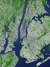
 View north on Hudson Waterfront | |
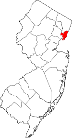
 Location within the U.S. state of New Jersey | |
 New Jersey's location within the U.S. | |
| Coordinates: 40°44′N 74°05′W / 40.73°N 74.08°W | |
| Country | |
| State | |
| Founded | 1840 |
| Named for | Henry Hudson |
| Seat | Jersey City[1] |
| Largest city | Jersey City (population and area) |
| Government | |
| • County executive | Craig Guy (D, term ends December 31, 2027) |
| Area | |
| • Total | 62.35 sq mi (161.5 km2) |
| • Land | 46.19 sq mi (119.6 km2) |
| • Water | 16.15 sq mi (41.8 km2) 25.9% |
| Population | |
| • Total | 724,854 |
| • Estimate | 705,472 |
| • Density | 15,691.5/sq mi (6,058.5/km2) |
| Congressional districts | 8th, 9th, 10th |
| Website | www |
Hudson County is the smallest and most densely populated county in the U.S. state of New Jersey. It lies west of the lower Hudson River, which was named for Henry Hudson, the sea captain who explored the area in 1609.[5] Part of New Jersey's Gateway Region in the New York metropolitan area, the county seat is Jersey City,[1] which is the county's largest city in terms of both population and area. The county is part of the North Jersey region of the state.[6]
As of the 2020 United States census, the county was the state's fourth-most-populous and fastest-growing county in the previous decade,[7] with a population of 724,854,[3][8] its highest decennial count ever and an increase of 90,588 (+14.3%) from the 2010 census count of 634,266,[9] which in turn reflected an increase of 25,291 (+4.2%) from the 2000 census population of 608,975.[10][11]
Home to 15,693 residents per square mile (6,130/km2) in 2020 and covering 46.19 square miles (119.6 km2) of land, Hudson County is New Jersey's geographically smallest and most densely populated county.[9] Hudson County shares extensive mass transit connections with Manhattan, located across the Hudson River, as well as with most of Northern and Central New Jersey.
Geography and climate
Climate
The average temperature of Hudson County is 51.89 °F, which is approximately the same as the state average of 51.93 °F, and lower than the national average of 54.45 °F.[12]
The county is located on the U.S. East Coast, approximately halfway between the Equator and the North Pole, which results in climate that is influenced by wet, dry, hot, and cold airstreams, and highly variable daily weather. Of New Jersey's five distinct climate regions, Hudson County is located in the Central region, which runs from New York Harbor and the Lower Hudson River to the great bend of the Delaware River near the state capital of Trenton. The high number of urban areas in this region are characterized by a high volume of industry and vehicular traffic that produce large amounts of pollutants. These substances, along with the large amounts of asphalt, brick, and concrete that compose buildings in the area, retain more atmospheric heat, which make it a regularly warmer "heat island" than surrounding suburban and rural areas. The northern border of the Central Zone is often the boundary between freezing and non-freezing precipitation in the winter, and between comfortable and comfortable sleeping conditions in the summer.[13]
Hudson County experiences precipitation an average of 116 days a year, during which it receives an annual average of 48 inches of rain, compared to the national average of 38, and 26 inches of snow, compared to the national average of 28. The summer high temperature in July is about 86 degrees, and its winter low in January is 25. On average, there are 219 sunny days per year in the county, compared with the national average of 205.[14]
| Jersey City | ||||||||||||||||||||||||||||||||||||||||||||||||||||||||||||
|---|---|---|---|---|---|---|---|---|---|---|---|---|---|---|---|---|---|---|---|---|---|---|---|---|---|---|---|---|---|---|---|---|---|---|---|---|---|---|---|---|---|---|---|---|---|---|---|---|---|---|---|---|---|---|---|---|---|---|---|---|
| Climate chart (explanation) | ||||||||||||||||||||||||||||||||||||||||||||||||||||||||||||
| ||||||||||||||||||||||||||||||||||||||||||||||||||||||||||||
| ||||||||||||||||||||||||||||||||||||||||||||||||||||||||||||
Average temperatures in the county seat of Jersey City have ranged from a low of 27 °F (−3 °C) in January to a high of 84 °F (29 °C) in July, although a record low of −15 °F (−26 °C) was recorded in February 1934 and a record high of 106 °F (41 °C) was recorded in July 1936. Average monthly precipitation ranged from 3.21 inches (82 mm) in February to 4.60 inches (117 mm) in July.[15]
Landforms and borders

According to the U.S. Census Bureau, as of the 2020 Census, the county had a total area of 62.35 square miles (161.5 km2), of which 46.19 square miles (119.6 km2) was land (74.1%) and 16.15 square miles (41.8 km2) was water (25.9%).[2] Based on land area, it is the smallest of New Jersey's 21 counties, less than half the size of the next smallest (Union County)[2] and the eighth-smallest of all counties in the United States.[16]
Hudson is located in the heart of New York metropolitan area in northeastern New Jersey. It is bordered by the Hudson River and Upper New York Bay to the east; Kill Van Kull to the south; Newark Bay and the Hackensack River or the Passaic River to the west; its only land border is shared with Bergen County to the north and west.[17]
The topography is marked by the New Jersey Palisades in the north with cliffs overlooking the Hudson to the east and less severe cuesta, or slope, to the west. They gradually level off to the southern peninsula, which is coastal and flat. The western region, around the Hackensack and Passaic is part of the New Jersey Meadowlands. Much of the land along the county's extensive shoreline and littoral zone was created by land reclamation.[18]

The highest point, at 260 feet (79 m) above sea level, is in West New York;[19][20] the lowest point is at sea level. North Bergen is the city with the second most hills per square mile in the United States behind San Francisco.[21]
Ellis Island and Liberty Island, opposite Liberty State Park, lie entirely within Hudson County's waters, which extend to the New York state line. Liberty Island is part of New York. Largely created through land reclamation, Ellis Island covers a land area of 27.5 acres (11.1 ha), with the 2.74-acre (1.11 ha) natural island and contiguous areas comprising a 3.3 acres (1.3 ha) exclave of New York.[22][23] Shooters Island, in the Kill van Kull, is also shared with New York. Robbins Reef Light sits atop a reef which runs parallel the Bayonne and Jersey City waterfront.

Much of the county lies between the Hackensack and Hudson Rivers on a geographically long narrow peninsula, (sometimes called Bergen Neck), which is a contiguous urban area where it is often difficult to know when one's crossed a civic boundary. These boundaries and the topography-including many hills and inlets-create very distinct neighborhoods. Kennedy Boulevard runs the entire length of the peninsula.[24] Numerous cuts for rail and vehicular traffic cross Bergen Hill.
Given its proximity to Manhattan, it is sometimes referred to as New York City's sixth borough.[25][26][27]
History
Etymology
Hudson County is named after the explorer Henry Hudson who charted much of the region.
The Lenape and New Netherland

Text je dostupný za podmienok Creative Commons Attribution/Share-Alike License 3.0 Unported; prípadne za ďalších podmienok. Podrobnejšie informácie nájdete na stránke Podmienky použitia.
Antropológia
Aplikované vedy
Bibliometria
Dejiny vedy
Encyklopédie
Filozofia vedy
Forenzné vedy
Humanitné vedy
Knižničná veda
Kryogenika
Kryptológia
Kulturológia
Literárna veda
Medzidisciplinárne oblasti
Metódy kvantitatívnej analýzy
Metavedy
Metodika
Text je dostupný za podmienok Creative
Commons Attribution/Share-Alike License 3.0 Unported; prípadne za ďalších
podmienok.
Podrobnejšie informácie nájdete na stránke Podmienky
použitia.
www.astronomia.sk | www.biologia.sk | www.botanika.sk | www.dejiny.sk | www.economy.sk | www.elektrotechnika.sk | www.estetika.sk | www.farmakologia.sk | www.filozofia.sk | Fyzika | www.futurologia.sk | www.genetika.sk | www.chemia.sk | www.lingvistika.sk | www.politologia.sk | www.psychologia.sk | www.sexuologia.sk | www.sociologia.sk | www.veda.sk I www.zoologia.sk


