

A | B | C | D | E | F | G | H | CH | I | J | K | L | M | N | O | P | Q | R | S | T | U | V | W | X | Y | Z | 0 | 1 | 2 | 3 | 4 | 5 | 6 | 7 | 8 | 9
Saint Pierre and Miquelon Saint-Pierre-et-Miquelon (French) | |
|---|---|
Overseas collectivity of France | |
| Territorial Collectivity of Saint-Pierre and Miquelon Collectivité territoriale de Saint-Pierre et Miquelon | |
| Motto: | |
| Anthem: La Marseillaise ("The Marseillaise") | |
 Location of Saint Pierre and Miquelon in North America. | |
| Country | |
| Cession from the United Kingdom | 30 May 1814 |
| Current status | 28 March 2003 |
| Capital and largest city | Saint-Pierre 46°46′40″N 56°10′40″W / 46.7778°N 56.1778°W |
| Official languages | French |
| Demonym(s) |
|
| Government | Devolved parliamentary local authority within French Republic |
| Emmanuel Macron | |
• Prefect | Christian Pouget |
| Bernard Briand | |
| Legislature | Territorial Council |
| French Parliament | |
• Senate | 1 senator (of 377) |
| 1 seat (of 577) | |
| Area | |
• Total | 242 km2 (93 sq mi) |
• Water (%) | negligible |
| Highest elevation | 240 m (790 ft) |
| Population | |
• March 2016 census | 6,008[1] |
• Density | 25/km2 (64.7/sq mi) (not ranked) |
| GDP (PPP) | 2004 estimate |
• Total | €161.1 million[2] |
• Per capita | €26,073[2] |
| Currency |
|
| Time zone | UTC−03:00 |
• Summer (DST) | UTC−02:00 |
| Date format | dd/mm/yyyy (AD) |
| Driving side | right |
| Calling code | +508 |
| ISO 3166 code | |
| Internet TLD | .pm |


Saint Pierre and Miquelon (/ˈmɪkəlɒn/),[3] officially the Territorial Collectivity of Saint-Pierre and Miquelon (French: Collectivité territoriale de Saint-Pierre et Miquelon [sɛ̃ pjɛʁ e miklɔ̃]), is a self-governing territorial overseas collectivity of France in the northwestern Atlantic Ocean, located near the Canadian province of Newfoundland and Labrador.[4][5] An archipelago of eight islands, St. Pierre and Miquelon is a vestige of the once-vast territory of New France.[4] Its residents are French citizens; the collectivity elects its own deputy to the National Assembly and participates in senatorial and presidential elections. It covers 242 km2 (93 sq mi) of land and had a population of 6,008 as of the March 2016 census[update].[1]
The islands are in the Gulf of St. Lawrence near the entrance of Fortune Bay, which extends into the southwestern coast of Newfoundland, near the Grand Banks of Newfoundland.[6] St. Pierre is 19 km (12 mi) from Point May on the Burin Peninsula of Newfoundland and 3,819 km (2,373 mi) from Brest, the nearest city in Metropolitan France.[7] The tiny Canadian Green Island lies 10 km (6 mi) east of Saint Pierre, roughly halfway to Point May.
Etymology
Saint-Pierre is French for Saint Peter, the patron saint of fishermen.[8]
The present name of Miquelon was first noted in the form of Micquetô, Miqueton or Micquellon in the French Basque sailor Martin de Hoyarçabal's 1579 navigational pilot for Newfoundland, Les voyages aventureux du Capitaine Martin de Hoyarsabal, habitant du çubiburu:
Giſant le cap de Breton & le pertuis de Miqueton est oest, y a 42 l." ... "Gisant la Colombe de S. Pierre le pertuis de Micquellon nord noroest & sud suest: y a 7 l.[9][a]
It has been claimed that the name Miquelon is a Basque form of Michael; Mikel and Mikels are usually named Mikelon in the Basque Country. Therefore, from Mikelon it may have been written in the French way with a q instead of a k.[10][11][12]
The Basque Country is divided between Spain and France, and most Basques live south of the border, so Miquelon may have been influenced by the Spanish name Miguelón, an augmentative form of Miguel meaning "big Michael". The adjoined island's name of "Langlade" is said to be an adaptation of l'île à l'Anglais (Englishman's Island).[12]
History
This article contains close paraphrasing of a non-free copyrighted source, France's Overseas Frontier. (October 2020) |


Before 1900
Archaeological evidence indicates that Indigenous peoples, such as the Beothuk, visited St Pierre and Miquelon, but it is not thought that they settled on the islands permanently.[citation needed] On 21 October 1520, the Portuguese explorer João Álvares Fagundes landed on the islands and named the St. Pierre island group the 'Eleven Thousand Virgins' (Portuguese: ilhas das Onze Mil Virgens), as the day marked the feast day of St. Ursula and her virgin companions.[13] In 1536 Jacques Cartier claimed the islands as a French possession on behalf of the King of France, Francis I.[14] Though already frequented by Mi'kmaq people[15] and by Basque and Breton fishermen,[14] the islands were not permanently settled until the end of the 17th century: four permanent inhabitants were counted in 1670, and 22 in 1691.[14]
In 1670, during Jean Talon's second tenure as Intendant of New France, a French officer annexed the islands after he discovered a dozen fishermen from France encamped there, naming them Saint-Pierre and Miquelon. During King William's War and Queen Anne's War, English forces launched multiple attacks against French colonial settlements on the islands, and by the early 18th century the colonists had abandoned Saint-Pierre and Miquelon altogether.[15] In the 1713 Treaty of Utrecht, which ended the War of the Spanish Succession, France ceded the islands to Britain.[15] The British renamed the island of Saint-Pierre to Saint Peter, and small numbers of colonists from Great Britain and Britain's American colonies began to settle on the islands.[16][17]
Under the terms of the 1763 Treaty of Paris, which put an end to the Seven Years' War, France ceded all its North American possessions to Britain, though the British granted fishing rights to French fishermen along the Newfoundland coast, and as part of that arrangement returned Saint-Pierre and Miquelon to France's control.[18] After France entered the American Revolutionary War on the side of the United States and declared war on Britain, a British force invaded Saint-Pierre and Miquelon and briefly occupied them, destroying all colonial settlements on the islands and deporting 2,000 colonists back to France.[19] In 1793, during the French Revolutionary Wars, another British force landed in Saint-Pierre and, in the following year, again deporting the French colonial population, and tried to establish a community of Anglophone settlers.[15]
The nascent British colony was in turn attacked by the French Navy in 1796. The Treaty of Amiens of 1802 returned the islands to France, but Britain reoccupied them when hostilities recommenced the next year.[15] The 1814 Treaty of Paris gave the islands back to France, though the UK occupied them yet again during the Hundred Days War in 1815. France then reclaimed the now uninhabited islands, in which all structures and buildings had been destroyed or fallen into disrepair.[15] The islands were resettled in 1816. The settlers, mostly Basques, Bretons and Normans, were joined by various other peoples, particularly from the nearby island of Newfoundland.[14] Only around the middle of the century did increased fishing bring a certain prosperity to the little colony.[15]
1900–1945
In 1903, the colony toyed with the idea of joining the United States, but in the end nothing came of the idea.[20] During the early 1910s the colony suffered severely as a result of unprofitable fisheries, and large numbers of its people emigrated to Nova Scotia and Quebec.[21] The draft imposed on all male inhabitants of conscript age after the beginning of World War I in 1914 crippled the fisheries, as their catch could not be processed by the older men or the women and children.[21] About 400 men from the colony served in the French military during World War I (1914–1918), 25% of whom died.[22] The increase in the adoption of steam trawlers in the fisheries also contributed to the reduction in employment opportunities.[21]
Smuggling had always been an important economic activity in the islands, but it became especially prominent in the 1920s with the institution of Prohibition in the United States from January 1920.[22] In 1931, the archipelago was reported by The New York Times to have imported 1,815,271 U.S. gallons (1,511,529 imperial gallons; 6,871,550 liters) of whisky from Canada in 12 months, most of it to be smuggled into the United States.[23][24] The end of Prohibition in 1933 plunged the islands once more into economic depression.[25]
During World War II, despite opposition from Canada, Britain,[26] and the United States, Charles de Gaulle's forces seized the archipelago from Vichy France, to which the local administrator had pledged its allegiance, in December 1941. In referendums on both islands, the population endorsed the takeover by Free France by over 98%.[26][27]
After 1945
The colony became a French Overseas Territory in 1946. After the 1958 French constitutional referendum, the territory of Saint-Pierre and Miquelon was asked to choose one of three options: becoming fully integrated with France, becoming a self-governing state within the French Community, or preserving the status of an overseas territory; it decided to remain a territory.[28] The archipelago became an overseas territory in 1946, then an overseas department on 19 July 1976,[29] before it acquired the status of territorial collectivity on 11 June 1985, thus withdrawing from the European Communities.[30][31]
Politics

Since March 2003, Saint Pierre and Miquelon has been an overseas collectivity with a special status.[4] The archipelago has two communes: Saint-Pierre and Miquelon-Langlade.[32] A third commune, Isle-aux-Marins, existed until 1945, when it was absorbed by the municipality of Saint-Pierre.[14] The inhabitants possess French citizenship and suffrage.[33] Saint Pierre and Miquelon sends a senator and a deputy to the National Assembly of France in Paris and enjoys a degree of autonomy concerning taxes, customs, and excise.[19][4]
France appoints the Prefect of Saint Pierre and Miquelon, who represents the national government in the territory.[25] The Prefect is in charge of national interests, law enforcement, public order, and, under the conditions set by the statute of 1985, administrative control.[34] Since January 2021, the current prefect is Christian Pouget.[35]
The local legislative body, the Territorial Council (French: Conseil territorial), has 19 members: four councillors from Miquelon-Langlade and 15 from Saint-Pierre.[32][4] The President of the Territorial Council is the head of a delegation of "France in the name of Saint Pierre and Miquelon" for international events such as the annual meetings of NAFO and ICCAT.[32]
On 10 January 2022, Saint Pierre and Miquelon made international news when MP Stéphane Claireaux, a member of the governing La République en Marche (LREM) was pelted with seaweed and stones in response to the government's new COVID-19 rules. The rule was announced by the state representative, the prefect, on 2 January for the island and angered residents.[36]
Defence and Gendarmerie
France is responsible for the defence of the islands.[4] The French Navy has maintained a patrol boat, the ex-trawler Fulmar, in the region since 1997.[37] Law enforcement in Saint Pierre and Miquelon is the responsibility of a branch of the French Gendarmerie Nationale; there are two police stations in the archipelago.[38]
Maritime boundary case

France claimed a 200-nautical-mile (370 km; 230 mi) exclusive economic zone for Saint-Pierre and Miquelon, and in August 1983 the naval ship Lieutenant de vaisseau Le Hénaff and the seismic ship Lucien Beaufort were sent to explore for oil in the disputed zone.[39] In addition to the potential oil reserves, cod fishing rights on the Grand Banks of Newfoundland were at stake in the dispute. In the late 1980s, indications of declining fish stocks began to raise serious concern over the depletion of the fishery.[39] In 1992, an arbitration panel awarded the islands an exclusive economic zone of 12,348 square kilometres (4,768 sq mi) to settle a longstanding territorial dispute with Canada, although it represents only 25% of what France had sought.[4]
The 1992 decision fixed the maritime boundaries between Canada and the islands, but did not demarcate the continental shelf.[40]
Geography
Located off the western end of the Newfoundland's Burin Peninsula, the archipelago of Saint Pierre and Miquelon comprises eight islands, totalling 242 square kilometres (93 sq mi), of which only two are inhabited.[4][41] The islands are bare and rocky, with steep coasts, and only a thin layer of peat to soften the hard landscape.[42] The islands, like Newfoundland, are geologically part of the northeastern end of the Appalachian Mountains.[4]
Miquelon-Langlade, the largest island, is in fact composed of two islands; Miquelon Island (also called Grande Miquelon, 110 km2 or 42 sq mi) is connected to Langlade Island (Petite Miquelon, 91 km2 or 35 sq mi) by the Dune de Langlade (also known as the Isthme de Langlade), a 10-kilometre (6.2 mi) long sandy tombolo.[31][5] A storm severed them in the 18th century, separating the two islands for several decades, before currents reconstructed the isthmus.[14] Morne de la Grande Montagne, the tallest point in the territory at 240 meters high, is located on Grande Miquelon.[4] The waters between Langlade and Saint-Pierre were called "the Mouth of Hell" (French: Gueule d'Enfer) until about 1900, as more than 600 shipwrecks have been recorded in that point since 1800.[43] In the north of Miquelon Island is the village of Miquelon-Langlade (710 inhabitants), while Langlade Island is almost deserted (only one inhabitant in the 1999 census).[14]
Saint Pierre Island, whose area is smaller, 26 square kilometres (10 sq mi), is the most populous and the commercial and administrative center of the archipelago. Saint-Pierre Airport has been in operation since 1999 and is capable of accommodating long-haul flights from France.[31]
A third, formerly inhabited island, Isle-aux-Marins, known as Île-aux-Chiens until 1931 and located a short distance from the port of Saint-Pierre, has been uninhabited since 1963.[14] The other main islands are Grand Colombier, Île aux Vainqueurs, and Île aux Pigeons.
-
 3D image of the Saint Pierre and Miquelon archipelago
 -
 Saint-Pierre aerial photo, 2013. Saint-Pierre Airport is at the lower right.
 -
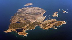
 Aerial view of St Pierre, the capital and largest town


Environment
Seabirds are the most common fauna.[33] Seals and other wildlife can be found in the Grand Barachois Lagoon of Miquelon. Every spring, whales migrating to Greenland are visible off the coasts of Saint-Pierre and Miquelon. Trilobite fossils have been found on Langlade. The stone pillars off the island coasts called "L'anse aux Soldats" eroded away and disappeared in the 1970s.[44] The rocky islands are barren, except for scrubby yews and junipers and thin volcanic soil.[43] The forest cover of the hills, except in parts of Langlade, had been removed for fuel long ago.[33]
Climate

In spite of being located at a similar latitude to the Bay of Biscay, the archipelago is characterized by a cold borderline humid continental/subarctic climate, under the influence of polar air masses and the cold Labrador Current.[41] The mild winters for being a subarctic climate also means it has influences of subpolar oceanic climate, thus being at the confluence of three climatic types. The February mean is just below the −3 °C (27 °F) isotherm for that classification.[45] Due to just three months being above 10 °C (50 °F) in mean temperatures and winter lows being so mild, Saint Pierre and Miquelon has a Köppen Climate Classification of Dfc, if bordering on Cfc due to the mildness of the winter and either Dfb or Cfb due to the closeness of the fourth-and fifth-warmest months to having mean temperatures at or above 10 °C (50 °F).
Typical maritime seasonal lag is also strong with September being warmer than June and March being colder than December. The average temperature is 5.3 °C (41.5 °F), with a temperature range of 19 °C (34 °F) between the warmest (15.7 °C (60.3 °F) in August) and coldest months (−3.6 °C (25.5 °F) in February).[41] Precipitation is abundant (1,312 mm or 51.7 in per year) and regular (146 days per year), falling as snow and rain.[41] Because of its location at the confluence of the cold waters of the Labrador Current and the warm waters of the Gulf Stream, the archipelago is also crossed a hundred days a year by fog banks, mainly in June and July.[41]
Two other climatic elements are remarkable: the extremely variable winds and haze during the spring to early summer.[46]
| Town | Sunshine (hours/yr) |
Rain (mm/yr) |
Snow (days/yr) |
Storm (days/yr) |
Fog (days/yr) |
|---|---|---|---|---|---|
| National average | 1,973 | 770 | 14 | 22 | 40 |
| Saint Pierre and Miquelon | 1,427 | 1,323.5 | 99.0 | 6.6 | 100.8[48] |
| Paris | 1,661 | 637 | 12 | 18 | 10 |
| Nice | 2,724 | 767 | 1 | 29 | 1 |
| Strasbourg | 1,693 | 665 | 29 | 29 | 56 |
| Brest | 1,605 | 1,211 | 7 | 12 | 75 |
| Climate data for St Pierre and Miquelon (1991–2020 averages, extremes 1941–present) | |||||||||||||
|---|---|---|---|---|---|---|---|---|---|---|---|---|---|
| Month | Jan | Feb | Mar | Apr | May | Jun | Jul | Aug | Sep | Oct | Nov | Dec | Year |
| Record high °C (°F) | 9.8 (49.6) |
9.4 (48.9) |
12.2 (54.0) |
13.8 (56.8) |
22.0 (71.6) |
25.1 (77.2) |
28.3 (82.9) |
26.2 (79.2) |
26.8 (80.2) |
20.1 (68.2) |
15.1 (59.2) |
12.8 (55.0) |
28.3 (82.9) |
| Mean daily maximum °C (°F) | 0.2 (32.4) |
−0.4 (31.3) |
1.4 (34.5) |
4.8 (40.6) |
8.9 (48.0) |
12.9 (55.2) |
17.1 (62.8) |
19.4 (66.9) |
16.6 (61.9) |
11.7 (53.1) |
7.2 (45.0) |
3.1 (37.6) |
8.6 (47.5) |
| Daily mean °C (°F) | −2.4 (27.7) |
−2.9 (26.8) |
−1.1 (30.0) |
2.1 (35.8) |
5.9 (42.6) |
9.9 (49.8) |
14.4 (57.9) |
16.8 (62.2) |
14.0 (57.2) |
9.3 (48.7) |
4.8 (40.6) |
0.8 (33.4) |
6.0 (42.8) |
| Mean daily minimum °C (°F) | −4.9 (23.2) |
−5.5 (22.1) |
−3.5 (25.7) |
−0.5 (31.1) |
2.8 (37.0) |
6.8 (44.2) |
11.6 (52.9) |
14.2 (57.6) |
11.3 (52.3) |
6.9 (44.4) |
2.5 (36.5) |
−1.5 (29.3) |
3.4 (38.1) |
| Record low °C (°F) | −17.4 (0.7) |
−18.7 (−1.7) |
−18.1 (−0.6) |
−9.8 (14.4) |
−4.5 (23.9) |
0.7 (33.3) |
4.9 (40.8) |
5.8 (42.4) |
1.7 (35.1) |
−2.6 (27.3) |
−9.2 (15.4) |
−14.6 (5.7) |
−18.7 (−1.7) |
| Average precipitation mm (inches) | 104.5 (4.11) |
98.5 (3.88) |
96.7 (3.81) |
88.0 (3.46) |
101.3 (3.99) |
93.8 (3.69) |
97.6 (3.84) |
101.0 (3.98) |
129.8 (5.11) |
134.4 (5.29) |
132.5 (5.22) |
117.2 (4.61) |
1,295.3 (51.00) |
| Average precipitation days (≥ 1.0mm) | 15.7 | 14.0 | 11.5 | 10.4 | 10.5 | 9.9 | 10.1 | 10.1 | 9.9 | 12.8 | 14.4 | 15.3 | 144.6 |
| Average rainy days | 3.03 | 4.07 | 5.17 | 8.83 | 12.87 | 14.60 | 18.50 | 11.27 | 6.33 | 4.13 | 4.70 | 3.53 | 97.03 |
| Average snowy days | 22.63 | 19.00 | 15.25 | 7.36 | 0.89 | 0.04 | 0.0 | 0.0 | Zdroj:https://en.wikipedia.org?pojem=Administrative_divisions_of_Saint_Pierre_and_Miquelon|||||