

A | B | C | D | E | F | G | H | CH | I | J | K | L | M | N | O | P | Q | R | S | T | U | V | W | X | Y | Z | 0 | 1 | 2 | 3 | 4 | 5 | 6 | 7 | 8 | 9
| Albany Kinjarling Western Australia | |||||||||
|---|---|---|---|---|---|---|---|---|---|
 York Street in Albany | |||||||||
 Albany | |||||||||
| Coordinates | 35°01′22″S 117°52′53″E / 35.022778°S 117.881389°E | ||||||||
| Population | 35,053 (2021)[1] (44th) | ||||||||
| • Density | 117.944/km2 (305.47/sq mi) | ||||||||
| Established | 26 December 1826 | ||||||||
| Postcode(s) | 6330 | ||||||||
| Elevation | 26 m (85 ft) | ||||||||
| Area | 297.2 km2 (114.7 sq mi)[2] (2011 urban) | ||||||||
| Time zone | AWST (UTC+8) | ||||||||
| Location | |||||||||
| LGA(s) | City of Albany | ||||||||
| State electorate(s) | Albany | ||||||||
| Federal division(s) | O'Connor | ||||||||
| |||||||||


Albany (/ˈælbəni/ AL-bən-ee;[a][3] Nyungar: Kinjarling) is a port city in the Great Southern region in the Australian state of Western Australia, 418 kilometres (260 mi) southeast of Perth, the state capital. The city centre is at the northern edge of Princess Royal Harbour, which is a part of King George Sound. The central business district is bounded by Mount Clarence to the east and Mount Melville to the west. The city is in the local government area of the City of Albany. While it is the oldest colonial, although not European,[b] settlement in Western Australia[c]—predating Perth and Fremantle by over two years—it was a semi-exclave of New South Wales for over four years until it was made part of the Swan River Colony.
The settlement was founded on 26 December 1826 as a military outpost of New South Wales for the purpose of forestalling French ambitions in the region.[4]: 61 To that end, on 21 January 1827, the commander of the outpost, Major Edmund Lockyer, formally took possession for the British Crown of the portion of New Holland not yet claimed by the Crown; that is, the portion west of the 129th meridian east, with the portion east already being claimed collectively by the Crown as New South Wales and Van Diemen's Land.[5] During the last decade of the 19th century, the town served as a gateway to the Eastern Goldfields. For many years, it was the colony's only deep-water port, having a place of eminence on shipping services between Britain and its Australian colonies. The opening of the Fremantle Inner Harbour in 1897,[6]: 51–55 however, saw its importance as a port decline, after which the town's industries turned primarily to agriculture, timber and later, whaling.
Contemporary Albany is the southern terminus for tourism in the region, and the state's south west,[7] which is known for its natural environment and preservation of its heritage. The town has a role in the ANZAC legend, being the last port of call for troopships departing Australia in the First World War. On 1 November 2014, the Australian and New Zealand Prime Ministers opened the National Anzac Centre in Mount Clarence, Albany, to commemorate 100 years since the first ANZAC troops departed from King George Sound. Approximately 40,000 people attended the commemoration events held between 30 October and 2 November 2014.[8]
An auxiliary submarine base for the US Navy's 7th Fleet was developed during the Second World War in the event the submarine base at Fremantle was lost. Also in the harbour was a Royal Australian Navy naval installation which provided for refuelling from four 5,100-tonne (5,000-long-ton) fuel tanks.[9]: 26
Etymology
Upon its establishment in 1826, the settlement was named Frederick Town in honour of Prince Frederick, Duke of York and Albany.[10][11][12] In 1831, the settlement was transferred to the control of the Swan River Colony and renamed Albany by Lieutenant-Governor James Stirling.[13]: 55–115
The name of the area in the Nyungar language of the Menang people is Kinjarling, which has been said to mean "place of plenty" and "place of rain".[14][15][16] In 2020, the City of Albany began, as part of an official dual-naming project, to give prominence to "Kinjarling" as the city's Aboriginal name.[14]
Early history
Kinjarling was home to Menang Noongar tribes during the summer season.[17] Early British explorers recorded evidence of fish traps located on Emu Point and on the French, now the Kalgan, River. Vancouver made attempts to find the inhabitants of the area but only found bark dwellings that were unoccupied. Later explorers made contact and were told to leave, but were accepted when they did not. Most of the British exploration was undertaken to survey the land and sea to assess the profitability of resources. The explorers occasionally noted encounters with Noongars. Native treatment laws and programs have affected the tribes since settlement.
Heritage buildings
There are a number of heritage buildings in Albany; see List of heritage places in the City of Albany and Category:Heritage places in Albany, Western Australia. These include:
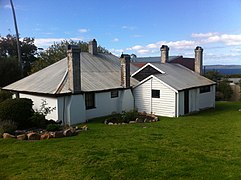
- The Old Farm, Strawberry Hill was established in 1827 as a government farm to feed the colonial soldiers stationed around King George's Sound. It is the oldest farm in Western Australia. The homestead, which became the home of the Government Resident in 1833, is an example of a colonial gentleman's residence. After a chequered history, the property was vested in the National Trust WA in 1964 and is now a house museum.
- Patrick Taylor Cottage (1832), Western Australia's oldest surviving dwelling, built in 1832 by the Morley Brothers. It is now maintained by the Albany Historical Society.
- St John's Church (1841–1848) is a stone building with shingled roofs in the Old Colonial Gothick Picturesque style. Set among trees, it was designed to be part of an overall contrived picturesque scene in the manner of an English garden landscape.[18]
- Scots Uniting Church (1892) was designed in the Victorian Academic Gothic style by Melbourne architect Evander McIver and built with local granite stonework.
- The complex now known as The Residency Museum was established in 1850 as a depot for the Convict Establishment in Albany. It is an L-shaped, single-storied, masonry building with a timber framed, timber shingled roof. In 1873 it was converted into the Resident Magistrate's home. It now serves as a museum.
- The Victorian Free Classical Revival style Town Hall (1888) is a two-storey stone building with a prominent clock tower, which dominates York Street, the main street of Albany. It has been put to many uses apart from council meetings, including public entertainment and public meetings of all kinds and even as the venue for the first regional meeting of the State Parliament.
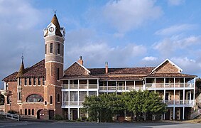
- The Old Post Office was built in two stages, the first was designed in 1869 by J Manning, the second, including a prominent tower, was designed in 1896 by George Temple-Poole. It now houses the Albany campus of the University of Western Australia.
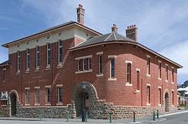
- The Court House, constructed of Albany brick and granite with a tiled roof, was designed in the Federation Romanesque style by the Public Works Department under the supervision of George Temple-Poole and Hillson Beasley in 1897.
- Another example of the work of George Temple Poole is the limestone and shingle Federation Arts and Crafts style Cottage Hospital, designed in 1886 and completed in 1897. It is one of the oldest hospitals in the state and served as such until 1962. It is now occupied by the Vancouver Arts Centre (named after the explorer George Vancouver).
- Images of heritage buildings
-

-
 Old Farm, drawing room
 -

-
 St.John's Church tower
 -
-
 Old Post Office, north front
 -
 Old Post Office, south front
 -

-
 Vancouver House, formerly the Cottage Hospital
 -

-
 Patrick Taylor Cottage, Duke Street


Some of the above information is derived from the State Heritage Register[19] where these places are registered. The assessment criteria contain more details.
Population
As of the 2021 census, the urban population of Albany was 35,053[1] making it the state's sixth-largest population centre.[20]
- Aboriginal and Torres Strait Islander people made up 4.1% of the population.
- 75.5% of people were born in Australia. The next most common countries of birth were England 7.2%, New Zealand 1.7%, Philippines 1.7%, 1.2% and Scotland 0.7%.
- 87.7% of people only spoke English at home. Other languages spoken at home included Filipino 0.6%, Tagalog 0.6%, Afrikaans 0.6%, Karen 0.5% and Italian 0.5%.
- The most common religious denominations were Anglican 11.9% and Catholic 10.7%. 49.9% had no religion and 7.5% did not respond.[1]
Geography

The city centre of Albany is located between the hills of Mount Melville and Mount Clarence, which look down into Princess Royal Harbour. Many beaches surround Albany, with Middleton Beach being the closest to the town centre. Other popular beaches include Frenchman Bay and Muttonbird Island.
Albany is 418 km (260 mi) SSE of the state capital, Perth, to which it is linked by Albany Highway.
Wine region
Albany is a sub-region of the Great Southern region of Western Australia.[21]
Coastline
_Westall.jpg)

.jpg)
The Albany coastline is notorious for deaths due to king waves washing people off rocks. The Torndirrup National Park features some of the more rugged coastline in the area. However, there are many beaches that are safe and usable.
Betty's Beach was named after Betty Jones, who used to go camping there with her family, and was initially called Betty's Bay.[22]
Frenchman Bay Beach is adjacent to the Torndirrup National Park, and was originally called Quarantine Bay, owing to the quarantine station set up by the British in 1826 on Mistaken Island at the northern end of Goode Beach[23]

Misery Beach, located 20 km (12 mi) south of Albany, was so named owing to the location of the whaling station at Albany that operated until 1978, causing offal to be washed ashore at Misery Beach and its sand and waters to be stained red. However, the beach was named Tourism Australia Best Beach 2022 by Tourism Australia, described a " all the boxes of what the typical beachgoer is looking for — uncrowded, crystal-white sand, turquoise waters and a very dramatic granite backdrop".[24]
Other beaches include:
- Emu Point
- Gull Rock Beach, also known as Boiler Beach
- Middleton Beach
- Nanarup Beach
- Muttonbird Beach
- Cosy Corner
- Two Peoples Bay, including Little Beach and Waterfall Beach
Climate
Albany has a warm-summer Mediterranean climate (Köppen Csb) with dry, warm summers, mild, wet winters, and pleasant springs and autumns.[25]: 5 Summers have short spells of very hot weather, but cool ocean breeze brings relief, especially during evenings and nights. The city is situated on what is promoted as the "Rainbow Coast", an appropriate title given the frequency of days with both sun and drizzle or showers. Albany has 44.8 clear days annually, just slightly lower than Melbourne's 48.6 days.
July is the wettest month, with a long-term average of 144 mm (5.67 in). Rain in excess of 0.2 mm (0.01 in) occurs on two days out of every three during an average winter. The driest month is February with a mean of 22.9 mm (0.90 in).
Albany received a record amount of rain on 20 November 2008 when violent storms swept across the Great Southern region. The town was flooded after 113.8 mm (4.48 in) of rain fell in a 24-hour period, the highest amount recorded since rainfall records began in 1877.[26] The wettest month on record was June 1920 when 292.8 mm (11.5 in) fell, while February 1877 and February 1879 remain the only rainless months.
| Climate data for Albany (35°02′S 117°53′E / 35.03°S 117.88°E), 1991-2020, extremes since 1880 | |||||||||||||
|---|---|---|---|---|---|---|---|---|---|---|---|---|---|
| Month | Jan | Feb | Mar | Apr | May | Jun | Jul | Aug | Sep | Oct | Nov | Dec | Year |
| Record high °C (°F) | 41.7 (107.1) |
44.8 (112.6) |
40.8 (105.4) |
37.7 (99.9) |
35.2 (95.4) |
24.6 (76.3) |
23.3 (73.9) |
27.3 (81.1) |
30.6 (87.1) |
36.2 (97.2) |
41.1 (106.0) |
42.2 (108.0) |
44.8 (112.6) |
| Mean daily maximum °C (°F) | 22.6 (72.7) |
22.9 (73.2) |
22.6 (72.7) |
21.2 (70.2) |
19.5 (67.1) |
17.7 (63.9) |
16.7 (62.1) |
17.1 (62.8) |
17.8 (64.0) |
18.9 (66.0) |
20.3 (68.5) |
21.4 (70.5) |
19.9 (67.8) |
| Mean daily minimum °C (°F) | 16.3 (61.3) |
17.0 (62.6) |
16.0 (60.8) |
13.9 (57.0) |
11.6 (52.9) |
10.0 (50.0) |
9.1 (48.4) |
9.3 (48.7) |
10.0 (50.0) |
11.9 (53.4) |
13.4 (56.1) |
14.8 (58.6) |
12.8 (55.0) |
| Record low °C (°F) | 7.8 (46.0) |
7.2 (45.0) |
6.1 (43.0) |
4.8 (40.6) |
2.4 (36.3) |
1.7 (35.1) |
0.1 (32.2) |
1.6 (34.9) |
2.0 (35.6) |
3.4 (38.1) |
5.6 (42.1) |
6.7 (44.1) |
0.1 (32.2) |
| Average precipitation mm (inches) | 20.3 (0.80) |
19.3 (0.76) |
39.5 (1.56) |
58.8 (2.31) |
87.2 (3.43) |
123.3 (4.85) |
128.5 (5.06) |
129.6 (5.10) |
105.2 (4.14) |
62.7 (2.47) |
51.3 (2.02) |
31.7 (1.25) |
857.4 (33.75) |
| Average precipitation days (≥ 1 mm) | 4.2 | 3.8 | 6.7 | 9.3 | 12.2 | 14.6 | 16.4 | 16.3 | 14.2 | 10.2 | 7.7 | 5.6 | 121.2 |
| Source: Bureau of Meteorology[27][28] | |||||||||||||
| Climate data for Albany Airport | |||||||||||||
|---|---|---|---|---|---|---|---|---|---|---|---|---|---|
| Month | Jan | Feb | Mar | Apr | May | Jun | Jul | Aug | Sep | Oct | Nov | Dec | Year |
| Record high °C (°F) | 45.6 (114.1) |
44.2 (111.6) |
41.2 (106.2) |
38.8 (101.8) |
32.6 (90.7) |
24.8 (76.6) |
22.5 (72.5) |
26.2 (79.2) |
27.9 (82.2) |
33.6 (92.5) |
39.2 (102.6) |
42.8 (109.0) |
45.6 (114.1) |
| Mean daily maximum °C (°F) | 24.8 (76.6) |
24.9 (76.8) |
24.1 (75.4) |
21.9 (71.4) |
19.0 (66.2) |
16.7 (62.1) |
15.8 (60.4) |
16.2 (61.2) |
17.3 (63.1) |
18.8 (65.8) |
20.9 (69.6) |
23.1 (73.6) |
20.3 (68.5) |
| Mean daily minimum °C (°F) | 13.7 (56.7) |
14.5 (58.1) |
13.4 (56.1) |
11.7 (53.1) |
9.8 (49.6) |
8.1 (46.6) |
7.5 (45.5) |
7.5 (45.5) |
8.1 (46.6) |
9.2 (48.6) |
10.8 (51.4) |
12.5 (54.5) |
10.6 (51.1) |
| Record low °C (°F) | 4.8 (40.6) |
5.1 (41.2) |
4.3 (39.7) |
3.2 (37.8) |
1.9 (35.4) |
0.0 (32.0) |
−0.2 (31.6) |
0.8 (33.4) |
0.7 (33.3) |
1.0 (33.8) |
2.7 (36.9) |
3.6 (38.5) |
−0.2 (31.6) |
| Average precipitation mm (inches) | 23.6 (0.93) |
22.3 (0.88) |
33.6 (1.32) |
61.3 (2.41) |
89.8 (3.54) |
108.0 (4.25) |
119.3 (4.70) |
106.8 (4.20) |
88.5 (3.48) |
70.8 (2.79) |
47.0 (1.85) |
27.8 (1.09) |
798.1 (31.42) |
| Average precipitation days (≥ 1mm) | 2.8 | 2.6 | 4.0
Zdroj:https://en.wikipedia.org?pojem=Albany,_Western_Australia Text je dostupný za podmienok Creative Commons Attribution/Share-Alike License 3.0 Unported; prípadne za ďalších podmienok. Podrobnejšie informácie nájdete na stránke Podmienky použitia.
Analytika
Antropológia Aplikované vedy Bibliometria Dejiny vedy Encyklopédie Filozofia vedy Forenzné vedy Humanitné vedy Knižničná veda Kryogenika Kryptológia Kulturológia Literárna veda Medzidisciplinárne oblasti Metódy kvantitatívnej analýzy Metavedy Metodika Text je dostupný za podmienok Creative
Commons Attribution/Share-Alike License 3.0 Unported; prípadne za ďalších
podmienok. www.astronomia.sk | www.biologia.sk | www.botanika.sk | www.dejiny.sk | www.economy.sk | www.elektrotechnika.sk | www.estetika.sk | www.farmakologia.sk | www.filozofia.sk | Fyzika | www.futurologia.sk | www.genetika.sk | www.chemia.sk | www.lingvistika.sk | www.politologia.sk | www.psychologia.sk | www.sexuologia.sk | www.sociologia.sk | www.veda.sk I www.zoologia.sk | ||||||||||