A | B | C | D | E | F | G | H | CH | I | J | K | L | M | N | O | P | Q | R | S | T | U | V | W | X | Y | Z | 0 | 1 | 2 | 3 | 4 | 5 | 6 | 7 | 8 | 9
Chester, Massachusetts | |
|---|---|
 U.S. Route 20 in Chester | |
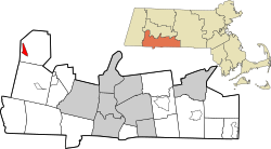
 Location in Hampden County in Massachusetts | |
| Coordinates: 42°16′45″N 72°58′43″W / 42.27917°N 72.97861°W | |
| Country | United States |
| State | Massachusetts |
| County | Hampden |
| Town | Chester |
| Area | |
| • Total | 1.43 sq mi (3.70 km2) |
| • Land | 1.40 sq mi (3.61 km2) |
| • Water | 0.03 sq mi (0.08 km2) |
| Elevation | 601.4 ft (183.3 m) |
| Population (2020) | |
| • Total | 552 |
| • Density | 395.70/sq mi (152.81/km2) |
| Time zone | UTC-5 (Eastern (EST)) |
| • Summer (DST) | UTC-4 (EDT) |
| ZIP code | 01011 |
| Area code | 413 |
| FIPS code | 25-13450 |
| GNIS feature ID | 0608286 |
Chester is a census-designated place that comprises the populated center of the town of Chester in Hampden County, Massachusetts, United States. The population of the CDP was 627 at the 2010 census,[2] out of 1,337 in the entire town of Chester. It is part of the Springfield, Massachusetts Metropolitan Statistical Area.
Geography
The Chester CDP is in the western part of the town of Chester, along U.S. Route 20 (Main Street) in the valley of the West Branch of the Westfield River where it is joined by Walker Brook. US 20 leads southeast down the Westfield River valley 18 miles (29 km) to Westfield and 29 miles (47 km) to Springfield, while to the west, US 20 turns up the Walker Brook valley and leads across the height of land of the Berkshires 17 miles (27 km) to Lee.
According to the United States Census Bureau, the Chester CDP has a total area of 1.4 square miles (3.7 km2), of which 0.03 square miles (0.08 km2), or 2.27%, are water.[2]
Demographics
| Census | Pop. | Note | %± |
|---|---|---|---|
| 2020 | 552 | — | |
| U.S. Decennial Census[3] | |||
References
- ^ "2020 U.S. Gazetteer Files". United States Census Bureau. Retrieved May 21, 2022.
- ^ a b "Geographic Identifiers: 2010 Census Summary File 1 (G001): Chester CDP, Massachusetts". American Factfinder. U.S. Census Bureau. Archived from the original on February 13, 2020. Retrieved August 5, 2017.
- ^ "Census of Population and Housing". Census.gov. Retrieved June 4, 2016.
Text je dostupný za podmienok Creative Commons Attribution/Share-Alike License 3.0 Unported; prípadne za ďalších podmienok. Podrobnejšie informácie nájdete na stránke Podmienky použitia.
Antropológia
Aplikované vedy
Bibliometria
Dejiny vedy
Encyklopédie
Filozofia vedy
Forenzné vedy
Humanitné vedy
Knižničná veda
Kryogenika
Kryptológia
Kulturológia
Literárna veda
Medzidisciplinárne oblasti
Metódy kvantitatívnej analýzy
Metavedy
Metodika
Text je dostupný za podmienok Creative
Commons Attribution/Share-Alike License 3.0 Unported; prípadne za ďalších
podmienok.
Podrobnejšie informácie nájdete na stránke Podmienky
použitia.
www.astronomia.sk | www.biologia.sk | www.botanika.sk | www.dejiny.sk | www.economy.sk | www.elektrotechnika.sk | www.estetika.sk | www.farmakologia.sk | www.filozofia.sk | Fyzika | www.futurologia.sk | www.genetika.sk | www.chemia.sk | www.lingvistika.sk | www.politologia.sk | www.psychologia.sk | www.sexuologia.sk | www.sociologia.sk | www.veda.sk I www.zoologia.sk

