

A | B | C | D | E | F | G | H | CH | I | J | K | L | M | N | O | P | Q | R | S | T | U | V | W | X | Y | Z | 0 | 1 | 2 | 3 | 4 | 5 | 6 | 7 | 8 | 9
Hillsborough County | |
|---|---|
 Downtown Tampa skyline | |
 Flag  Seal Logo | |
 Location within the U.S. state of Florida | |
 Florida's location within the U.S. | |
| Coordinates: 27°55′N 82°21′W / 27.91°N 82.35°W | |
| Country | |
| State | |
| Founded | January 25, 1834 |
| Named for | Wills Hill, Earl of Hillsborough |
| Seat | Tampa |
| Largest city | Tampa |
| Area | |
| • Total | 1,266 sq mi (3,280 km2) |
| • Land | 1,020 sq mi (2,600 km2) |
| • Water | 246 sq mi (640 km2) 19.4% |
| Population (2020) | |
| • Total | 1,459,762[1] |
| • Density | 1,431/sq mi (553/km2) |
| Time zone | UTC−5 (Eastern) |
| • Summer (DST) | UTC−4 (EDT) |
| Congressional districts | 14th, 15th, 16th |
| Website | www |
Hillsborough County is located in the west-central portion of the U.S. state of Florida. In the 2020 census, the population was 1,459,762,[2] making it the fourth-most populous county in Florida and the most populous county outside the Miami metropolitan area. A 2021 estimate has the population of Hillsborough County at 1,512,070 people with a yearly growth rate of 1.34%,[3] which itself is greater than the populations of 12 states according to their 2019 population estimates.[4] Its county seat and largest city is Tampa.[5] Hillsborough County is part of the Tampa–St. Petersburg–Clearwater Metropolitan Statistical Area.
History


Hillsborough County was created on January 25, 1834, from Alachua and Monroe Counties,[6] during the U.S. territorial period (1822–1845). The new county was named for Wills Hill, the Earl of Hillsborough, who served as British Secretary of State for the Colonies from 1768 to 1772.[7] The County was created through efforts by Augustus Steele.[8]
The county's 1834 area was much larger and included eight other present-day counties: Charlotte County, DeSoto, Hardee, Manatee, Pasco, Pinellas, Polk, and Sarasota.[9]
The last significant change in Hillsborough County's borders was the separation of its western section to create Pinellas County in 1911.[citation needed]
On New Year's Day in 1914, the St. Petersburg-Tampa Airboat Line initiated the first scheduled commercial airline service in the world, from St. Petersburg to Tampa.[10]
Geography
According to the U.S. Census Bureau, the county has a total area of 1,266 square miles (3,280 km2), of which 1,020 square miles (2,600 km2) are land and 246 square miles (640 km2) (19.4%) are covered by water.[11] About 158.27 miles (254.71 km) of shoreline are on Tampa Bay.
The county's unincorporated area is around 888 square miles (2,300 km2), more than 84% of the total land area. Municipalities account for 163 square miles (420 km2). The modern boundaries of the county place it midway along the west coast of Florida.[citation needed]
A narrow portion of Hillsborough County to the south, consisting almost exclusively of water, extends west to the Gulf of Mexico roughly along the Tampa Port Shipping Channel. This has the effect of keeping Hillsborough County from being technically landlocked. The central portion of the Sunshine Skyway Bridge is in Hillsborough County. So is Egmont Key, at the entrance to Tampa Bay; this narrow strip of land separates Pinellas County from Manatee County. The northernmost tip of a spoil island just west of Port Manatee also lies in Hillsborough County.[citation needed]
Hillsborough is home to Alafia River State Park and Hillsborough River state parks, and to the C. W. Bill Young Regional Reservoir and Lithia Springs, one of the largest natural springs in Florida.[citation needed]
-
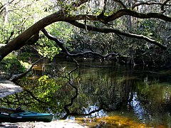 On the Alafia River near Lithia Springs Park
 -
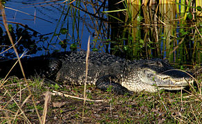 An alligator in the Alafia River State Park
 -
 Hurrah Lake on the Alafia River
 -

-
 On the Hillsborough River near Lettuce Lake Park


Adjacent counties
- Pasco County - north
- Polk County - east
- Manatee County - south
- Pinellas County - west
- Hardee County - southeast
Demographics
| Census | Pop. | Note | %± |
|---|---|---|---|
| 1840 | 452 | — | |
| 1850 | 2,377 | 425.9% | |
| 1860 | 2,981 | 25.4% | |
| 1870 | 3,216 | 7.9% | |
| 1880 | 5,814 | 80.8% | |
| 1890 | 14,941 | 157.0% | |
| 1900 | 36,013 | 141.0% | |
| 1910 | 78,374 | 117.6% | |
| 1920 | 88,257 | 12.6% | |
| 1930 | 153,519 | 73.9% | |
| 1940 | 180,148 | 17.3% | |
| 1950 | 249,894 | 38.7% | |
| 1960 | 397,788 | 59.2% | |
| 1970 | 490,265 | 23.2% | |
| 1980 | 646,960 | 32.0% | |
| 1990 | 834,054 | 28.9% | |
| 2000 | 998,948 | 19.8% | |
| 2010 | 1,229,226 | 23.1% | |
| 2020 | 1,459,762 | 18.8% | |
| 2023 (est.) | 1,535,564 | [12] | 5.2% |
| U.S. Decennial Census[13] 1790-1960[14] 1900-1990[15] 1990-2000[16] 2010-2019[2] 2022[17] | |||
2020 Census
| Race | Pop 2010 | Pop 2020 | % 2010 | % 2020 |
|---|---|---|---|---|
| White (NH) | 660,565 | 667,791 | 53.74% | 45.75% |
| Black or African American (NH) | 191,260 | 224,479 | 15.56% | 15.38% |
| Native American or Alaska Native (NH) | 2,948 | 2,817 | 0.24% | 0.19% |
| Asian (NH) | 41,328 | 69,928 | 3.36% | 4.79% |
| Pacific Islander (NH) | 703 | 914 | 0.06% | 0.06% |
| Some Other Race (NH) | 2,992 | 9,655 | 0.24% | 0.66% |
| Mixed/Multi-Racial (NH) | 22,795 | 56,797 | 1.85% | 3.89% |
| Hispanic or Latino | 306,635 | 427,381 | 24.95% | 29.28% |
| Total | 1,229,226 | 1,459,762 | 100.00% | 100.00% |
As of the 2020 United States census, there were 1,459,762 people, 539,919 households, and 338,683 families residing in the county.
2010 Census

U.S. Census Bureau 2010 Ethnic/Race Demographics:[21][22]
- White (non-Hispanic) (71.3% when including White Hispanics): 53.7% (12.1% German, 11.0% Irish, 8.9% English, 6.7% Italian, 2.6% French, 2.4% Polish, 1.9% Scottish, 1.6% Scotch-Irish, 1.3% Dutch, 0.8% Russian, 0.8% Swedish, 0.7% Welsh, 0.6% French Canadian, 0.6% Norwegian, 0.5% Hungarian, 0.5% Greek)[21]
- Black (non-Hispanic) (16.7% when including Black Hispanics): 15.6% (2.4% West Indian/Afro-Caribbean American 0.9% Subsaharan African)[21][23]
- Hispanic or Latino of any race: 24.9% (7.4% Puerto Rican, 5.3% Cuban, 5.3% Mexican, 1.2% Colombian, 1.1% Dominican, 0.7% Spaniard, 0.5% Honduran)[21][24]
- Asian: 3.4% (1.2% Indian, 0.5% Vietnamese, 0.5% Filipino, 0.4% Chinese, 0.4% Other Asian, 0.3% Korean, 0.1% Japanese)[21][22]
- Two or more races: 3.1%
- American Indian and Alaska Native: 0.4%
- Native Hawaiian and Other Pacific Islander: 0.1%[21][22]
- Other Races: 5.0% (0.6% Arab)[21]
In 2010, 6.0% of the Hillsborough's population considered themselves to be of only American ancestry (regardless of race or ethnicity.)[21]
Of the 536,092 households, 29.74% had children under the age of 18 living with them, 44.25% were married couples living together, 14.76% had a female householder with no husband present, and 35.69% were not families. About 27.12% of all households were made up of individuals, and 7.96% (2.35% male and 5.61% female) had someone living alone who was 65 years of age or older. The average household size was 2.55 and the average family size was 3.11.[25][26]
The age distribution was 23.9% under the age of 18, 10.5% from 18 to 24, 28.3% from 25 to 44, 25.4% from 45 to 64, and 11.8% were 65 years of age or older. The median age was 36.1 years. For every 100 females, there were 95.1 males. For every 100 females age 18 and over, there were 92.1 males.[25][26]
The median income for a household in the county was $49,536, and for a family was $59,886. Males had a median income of $43,125 versus $35,184 for females. The per capita income for the county was $27,062. About 10.7% of families and 14.2% of the population were below the poverty line, including 19.9% of those under age 18 and 9.6% of those aged 65 or over.[27]
In 2010, 15.1% of the county's population was foreign born, with 44.5% being naturalized American citizens. Of foreign-born residents, 67.5% were born in Latin America, 16.7% born in Asia, 9.2% were born in Europe, 3.2% born in Africa, 3.1% in North America, and 0.3% were born in Oceania.[citation needed]
2000 Census
As of the census of 2000, 998,948 people, 391,357 households, and 255,164 families resided in the county. The population density was 951 inhabitants per square mile (367/km2). The 425,962 housing units averaged 405 per square mile (156/km2). The racial makeup of the county was 75.17% White (63.3% Non-Hispanic White),[28] 14.96% Black or African American, 0.39% Native American, 2.20% Asian, 0.07% Pacific Islander, 4.66% from other races, and a 2.56% from two or more races. 17.99% of the population were Hispanic or Latino of any race. The county was the thirty-second most populous county in the nation.
Of the 391,357 households, 31.40% had children under the age of 18 living with them, 47.70% were married couples living together, 13.20% had a female householder with no husband present, and 34.80% were not families. Roughly 26.90% of all households were made up of individuals, and 8.10% had someone living alone who was 65 years of age or older. The average household size was 2.51 and the average family size was 3.07.
The age distribution was: 25.30% under the age of 18, 9.30% from 18 to 24, 31.70% from 25 to 44, 21.70% from 45 to 64, and 12.00% were 65 years of age or older. The median age was 35 years. For every 100 females there were 95.80 males. For every 100 females age 18 and over, there were 92.70 males.
The median income for a household in the county was $40,663, and for a family was $48,223. Males had a median income of $34,111 versus $26,962 for females. The per capita income for the county was $21,812. About 9.10% of families and 12.50% of the population were below the poverty line, including 17.20% of those under age 18 and 10.00% of those age 65 or over.
| Level of Education | ||||
|---|---|---|---|---|
| Level | Hillsborough Co. | Florida | U.S. | |
|
| ||||
| College/Associate Degree | 29.0% | 28.8% | 27.4% | |
| Bachelor's Degree | 16.7% | 14.3% | 15.5% | |
| Master's or PhD | 8.4% | 8.1% | 8.9% | |
| Total | 54.1% | 51.2% | 51.8% | |
Source: U.S. Census[29]
Languages
As of 2010, 74.59% of the population spoke only English at home, 19.52% spoke Spanish, 0.56% French Creole (mainly Haitian Creole), and 0.51% spoke Vietnamese as their mother language.[30] In total, 25.41% of the population spoke a language other than English as their primary language.[30]
Politics and government
This section needs additional citations for verification. (July 2022) |
Voter registration
According to the Secretary of State's office, Democrats are a plurality of registered voters in Hillsborough County.
| Hillsborough county voter registration & party enrollment as of March 31, 2024[31] | |||||
|---|---|---|---|---|---|
| Political party | Total Voters | Percentage | |||
| Democratic | 289,116 | 35.11% | |||
| Republican | 280,659 | 34.08% | |||
| Independent | 232,320 | 28.21% | |||
| Minor parties | 21,472 | 2.61% | |||
| Total | 823,567 | 100.00% | |||
Statewide and national elections
Hillsborough County tends to lean Democratic, having not been won by a Republican presidential candidate since the 2004 election. For the last quarter-century, it has been a powerful swing county in one of the nation's most important swing states. It is part of the politically important I-4 Corridor between Tampa Bay and Orlando, an area that historically decides most elections in Florida. Hillsborough was considered a bellwether county, voting for the statewide winner in every presidential election from 1964-2012. It has also voted for the winner of the presidency in every election since 1928 except twice, voting for the loser only in 1992 and 2016. The southern portion of the county, around Tampa, is powerfully Democratic, while the northern and eastern portions are heavily Republican.
On the statewide level, the county also tends to lean Democratic with Democrats Bill Nelson for senator and Andrew Gillum for governor both winning the county in the 2018 elections. However, Republican senator Marco Rubio did win the county in his 2010, 2016 and 2022 senatorial campaigns and Republican Governor Ron Desantis won it in his 2022 gubernatorial campaign after the county supported Democrats for the previous three gubernatorial elections since 2010.
In 2008, Barack Obama won the county by seven points, the first Democrat to capture the county since Bill Clinton's re-election victory in 1996.[32] Obama won Hillsborough again in 2012 over Republican presidential nominee Mitt Romney by roughly the same margin.
In 2016, Donald Trump became the first Republican since Calvin Coolidge in 1924 to win a presidential election without carrying the county.
| Year | Republican | Democratic | Third party | |||
|---|---|---|---|---|---|---|
| No. | % | No. | % | No. | % | |
| 2020 | 327,398 | 45.85% | 376,367 | 52.71% | 10,303 | 1.44% |
| 2016 | 266,870 | 44.19% | 307,896 | 50.99% | 29,124 | 4.82% |
| 2012 | 250,186 | 46.04% | 286,467 | 52.71% | 6,776 | 1.25% |
| 2008 | 236,355 | 45.94% | 272,963 | 53.05% | 5,183 | 1.01% |
| 2004 | 245,576 | 53.01% | 214,132 | 46.23% | 3,514 | 0.76% |
| 2000 | 180,794 | 50.17% | 169,576 | 47.06% | 9,984 | 2.77% |
| 1996 | 136,656 | 44.33% | 144,266 | 46.80% | 27,349 | 8.87%
Zdroj:https://en.wikipedia.org?pojem=Hillsborough_County,_Florida Text je dostupný za podmienok Creative Commons Attribution/Share-Alike License 3.0 Unported; prípadne za ďalších podmienok. Podrobnejšie informácie nájdete na stránke Podmienky použitia.
Analytika
Antropológia Aplikované vedy Bibliometria Dejiny vedy Encyklopédie Filozofia vedy Forenzné vedy Humanitné vedy Knižničná veda Kryogenika Kryptológia Kulturológia Literárna veda Medzidisciplinárne oblasti Metódy kvantitatívnej analýzy Metavedy Metodika Text je dostupný za podmienok Creative
Commons Attribution/Share-Alike License 3.0 Unported; prípadne za ďalších
podmienok. www.astronomia.sk | www.biologia.sk | www.botanika.sk | www.dejiny.sk | www.economy.sk | www.elektrotechnika.sk | www.estetika.sk | www.farmakologia.sk | www.filozofia.sk | Fyzika | www.futurologia.sk | www.genetika.sk | www.chemia.sk | www.lingvistika.sk | www.politologia.sk | www.psychologia.sk | www.sexuologia.sk | www.sociologia.sk | www.veda.sk I www.zoologia.sk |