

A | B | C | D | E | F | G | H | CH | I | J | K | L | M | N | O | P | Q | R | S | T | U | V | W | X | Y | Z | 0 | 1 | 2 | 3 | 4 | 5 | 6 | 7 | 8 | 9
Kobe
神戸市 | |
|---|---|
| Kobe City | |
From top left: Kobe Port Tower and Kobe Maritime Museum of the Meriken Park, Old Kobe Residency 15th Hall (The Former American Consulate in Kobe) of Kobe foreign settlement, Hyogo Prefectural Museum of Art, the Chinatown of Nankin-machi, Ikuta Shrine and a view from The Former Thomas House of Kitano-cho | |
 Flag  Seal | |
 Interactive map outlining Kobe | |
 Location of Kobe in Hyōgo Prefecture | |
 Kobe | |
| Coordinates: 34°41′24″N 135°11′44″E / 34.69000°N 135.19556°E | |
| Country | Japan |
| Region | Kansai |
| Prefecture | Hyōgo Prefecture |
| First official record | 201 AD |
| City Status | April 1, 1889 |
| Government | |
| • Mayor | Kizō Hisamoto |
| Area | |
| • Designated city | 557.02 km2 (215.07 sq mi) |
| Population (June 1, 2021) | |
| • Designated city | 1,522,188 (7th) |
| • Metro [1] (2015) | 2,419,973 (6th) |
| Time zone | UTC+9 (Japan Standard Time) |
| Phone number | 078-331-8181 |
| Address | 6-5-1 Kano-chō, Chūō-ku, Kōbe-shi, Hyōgo-ken 650-8570 |
| Climate | Cfa |
| Website | City of Kobe |
| Symbols | |
| Flower | Hydrangea |
| Tree | Camellia sasanqua |


.jpg)


| Kobe | |||||
|---|---|---|---|---|---|
| Japanese name | |||||
| Kyūjitai | 神戶 | ||||
| Shinjitai | 神戸 | ||||
| |||||
Kobe (/ˈkoʊbeɪ/ KOH-bay; Japanese: 神戸, romanized: Kōbe, pronounced [koꜜːbe] ), officially Kobe City (神戸市, Kōbe-shi), is the capital city of Hyōgo Prefecture, Japan. With a population around 1.5 million, Kobe is Japan's seventh-largest city and the third-largest port city after Tokyo and Yokohama. It is located in the Kansai region, which makes up the southern side of the main island of Honshū, on the north shore of Osaka Bay. It is part of the Keihanshin metropolitan area along with Osaka and Kyoto.[2] The Kobe city centre is located about 35 km (22 mi) west of Osaka and 70 km (43 mi) southwest of Kyoto.
The earliest written records regarding the region come from the Nihon Shoki, which describes the founding of the Ikuta Shrine by Empress Jingū in AD 201.[3][4] For most of its history, the area was never a single political entity, even during the Tokugawa period, when the port was controlled directly by the Tokugawa shogunate. Kobe did not exist in its current form until its founding in 1889. Its name comes from Kanbe (神戸, an archaic title for supporters of the city's Ikuta Shrine).[5][6] Kobe became one of Japan's designated cities in 1956.
Kobe was one of the cities to open for trade with the West following the 1853 end of the policy of seclusion and has retained its cosmopolitan character ever since with a rich architectural heritage dating back to the Meiji era. While the 1995 Great Hanshin earthquake diminished some of Kobe's prominence as a port city, it remains Japan's fourth-busiest container port.[7] Companies headquartered in Kobe include ASICS, Kawasaki Heavy Industries, and Kobe Steel, while over 100 international corporations have their Asian or Japanese headquarters in the city, including Eli Lilly and Company, Procter & Gamble, Boehringer Ingelheim, and Nestlé.[8][9] The city is the point of origin and namesake of Kobe beef, the home of Kobe University, and the site of one of Japan's most famous hot spring resorts, Arima Onsen.
History
Origins
Tools found in western Kobe demonstrate the area was populated at least from the Jōmon period.[10]
The natural geography of the area, particularly of Wada Cape in Hyōgo-ku, led to the development of a port, which would remain the economic center of the city.[11] Some of the earliest written documents mentioning the region include the Nihon Shoki, which describes the founding of the Ikuta Shrine by Empress Jingū in AD 201.[3]
- Gallery
-

-

-
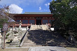 Taisan-ji. The main hall is a National Treasure of Japan (built in 716).
.jpg)


Nara and Heian periods
During the Nara and Heian periods, the port was known by the name Ōwada Anchorage (Ōwada-no-tomari) and was one of the ports from which imperial embassies to China were dispatched.[4][10] The city was briefly the capital of Japan in 1180, when Taira no Kiyomori moved his grandson Emperor Antoku to Fukuhara-kyō in present-day Hyōgo-ku.[10] The Emperor returned to Kyoto after about five months.[4] Shortly thereafter in 1184, the Taira fortress in Hyōgo-ku and the nearby Ikuta Shrine became the sites of the Genpei War battle of Ichi-no-Tani between the Taira and Minamoto clans. The Minamoto prevailed, pushing the Taira further.
- Gallery
-

-
 Marker indicating the former location of Fukuhara-kyō
 -


Kamakura period
As the port grew during the Kamakura period, it became an important hub for trade with China and other countries. In the 13th century, the city came to be known by the name Hyōgo Port (兵庫津, Hyōgo-tsu).[11] During this time, Hyōgo Port, along with northern Osaka, composed the province of Settsu (most of today's Kobe belonged to Settsu except Nishi Ward and Tarumi Ward, which belonged to Harima).
- Gallery
-

-
_(BM_2008,3037.02214).jpg)

Edo period
Later, during the Edo period, the eastern parts of present-day Kobe came under the jurisdiction of the Amagasaki Domain and the western parts under that of the Akashi Domain, while the center was controlled directly by the Tokugawa shogunate.[12][13] It was not until the abolition of the han system in 1871 and the establishment of the current prefecture system that the area became politically distinct.
- Gallery
-
 Hanakuma Castle

Meiji period
Hyōgo Port was opened to foreign trade by the Shogunal government at the same time as Osaka on January 1, 1868, just before the advent of the Boshin War and the Meiji Restoration.[14] At the time of the opening of the city for foreign trade, the area saw intense fighting resulting from the civil war in progress. Shortly after the opening of Kobe to trade, the Kobe Incident occurred, where several western soldiers sustained wounds from gunfire by troops from Bizen. The region has since been identified with the West and many foreign residences from the period remain in Kobe's Kitano area.
- Gallery
-
 Kobe foreign settlement Kaigan-dōri Avenue around 1885
 -
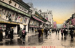 Shinkaichi theatre street in Kobe (Taisho era)
 -
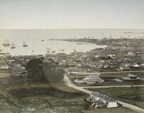 Hyōgo Port in the 19th century[15]
 -
 The Bund, built in the 1860s–1930s
 -
 Kitano area, built in the 1880s–1910s
 -
 Former Hyogo prefectural office, built in 1902
 -
 This nishiki-e (colored woodcut) shows a foreign steamboat entering Hyōgo Port shortly after its opening to the West in the late 19th century.


Modern era
Kobe, as it is known today, was founded on April 1, 1889, and was designated on September 1, 1956 by government ordinance. The history of the city is closely tied to that of the Ikuta Shrine, and the name "Kobe" derives from kamube (神戸, later kanbe), an archaic name for those who supported the shrine.[5][6]
During World War II, Kobe was lightly bombed in the Doolittle Raid on April 18, 1942, along with Tokyo and a few other cities. Eventually, it was bombed again with incendiary bombs by B-29 Superfortress bombers on March 16 and 17, 1945, causing the death of 8,841 residents and the destruction of 21% of Kobe's urban area. This incident inspired the well-known Studio Ghibli film Grave of the Fireflies and the book by Akiyuki Nosaka on which the film was based. It also features in the motion picture A Boy Called H.
Following continuous pressure from citizens, on March 18, 1975, the Kobe City Council passed an ordinance banning vessels carrying nuclear weapons from Kobe Port. This effectively prevented any U.S. warships from entering the port, because U.S. policy is to never disclose whether any given warship is carrying nuclear weapons. This nonproliferation policy has been termed the "Kobe formula".[16][17]
On January 17, 1995, a magnitude 6.9 earthquake occurred at 5:46 am JST near the city. About 6,434 people in the city were killed, 212,443 were made homeless, and large parts of the port facilities and other parts of the city were destroyed.[18][19] The earthquake destroyed portions of the Hanshin Expressway, an elevated freeway that dramatically toppled over. In Japan, this earthquake is known as the Great Hanshin earthquake (or the Hanshin-Awaji earthquake). To commemorate Kobe's recovery from it, the city holds an event every December called the Luminarie, where the city center is decorated with illuminated metal archways.
The Port of Kobe was Japan's busiest port and one of Asia's top ports until the Great Hanshin earthquake.[20] Kobe has since dropped to fourth in Japan and, as of 2012, was the 49th-busiest container port worldwide.
- Gallery
-
 Map of the Foreign Settlement
 -
 View of Kobe after the bombing in 1945
 -
 Port of Kobe in 1966
 -
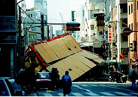 Damage in Sannomiya after the Great Hanshin earthquake in 1995
 -
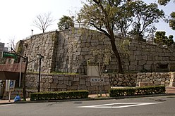
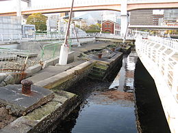 Kobe Earthquake Memorial Park


Geography

Wedged between the coast and the mountains, the city of Kobe is long and narrow. To the east is the city of Ashiya, while the city of Akashi lies to its west. Other adjacent cities include Takarazuka and Nishinomiya to the east and Sanda and Miki to the north.
The landmark of the port area is the red steel Port Tower. A ferris wheel sits in nearby Harborland, a notable tourist promenade.[citation needed] Two artificial islands, Port Island and Rokkō Island, have been constructed to give the city room to expand.
Away from the seaside at the heart of Kobe lie the Motomachi and Sannomiya districts, as well as Kobe's Chinatown, Nankin-machi, all well-known retail areas. A multitude of train lines cross the city from east to west. The main transport hub is Sannomiya Station, with the eponymous Kobe Station located to the west and the Shinkansen Shin-Kobe Station to the north.
Mount Rokkō overlooks Kobe at an elevation of 931 m (3,054 ft). During autumn, it is famous for the rich change in colors of its forests.

Wards
Kobe has nine wards (ku):
- Nishi-ku: The westernmost area of Kobe, Nishi-ku overlooks the city of Akashi and is the site of Kobe Gakuin University. This ward has the largest population, with 247,000 residents.[21]
- Kita-ku: Kita-ku is the largest ward by area and contains the Rokko Mountain Range, including Mount Rokkō and Mount Maya. The area is well known for its rugged landscape and hiking trails. The onsen resort town of Arima also lies within Kita-ku.
- Tarumi-ku: Tarumi-ku is a mostly residential area. The longest suspension bridge in the world, the Akashi Kaikyō Bridge, extends from Maiko in Tarumi-ku to Awaji Island to the south. A relatively new addition to Kobe, Tarumi-ku was not a part of the city until 1946.
- Suma-ku: Suma-ku is the site of Suma beach, attracting visitors during the summer months.
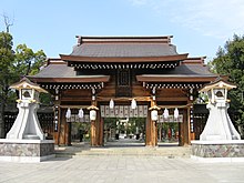
- Nagata-ku: Nagata-ku is the site of Nagata Shrine, one of the three "Great Shrines" in Kobe.
- Hyōgo-ku: At various times known as Ōwada Anchorage or Hyōgo Port, this area is the historical heart of the city. Shinkaichi in Hyogo-ku was once the commercial center of Kobe, but was heavily damaged during World War II, and since, Hyogo-ku has lost much of its former prominence.
- Chūō-ku: Chūō (中央) literally means "central" and, as such, Chūō-ku is the commercial and entertainment center of Kobe. Sannomiya, Motomachi and Harborland make up the main entertainment areas in Kobe. Chūō-ku includes the city hall and Hyōgo prefectural government offices. Port Island and Kobe Airport lie in the southern part of this ward.
- Nada-ku: The site of Oji Zoo and Kobe University, Nada is known for its sake. Along with Fushimi in Kyoto, it accounts for 45% of Japan's sake production.[22]
- Higashinada-ku: The easternmost area of Kobe, Higashinada-ku borders the city of Ashiya. The man-made island of Rokko makes up the southern part of this ward.
| Wards of Kobe | ||||||
|---|---|---|---|---|---|---|
| Place Name | Map of Kobe | |||||
| Rōmaji | Kanji | Population | Land area in km2 | Pop. density
per km2 |
||
| 1 | Nishi-ku | 西区 | 240,386 | 138.01 | 1,742 |  |
| 2 | Kita-ku | 北区 | 212,211 | 240.29 | 883 | |
| 3 | Tarumi-ku | 垂水区 | 216,337 | 28.11 | 7,696 | |
| 4 | Suma-ku | 須磨区 | 158,196 | 28.93 | 5,468 | |
| 5 | Nagata-ku | 長田区 | 95,155 | 11.36 | 8,376 | |
| 6 | Hyōgo-ku | 兵庫区 | 107,307 | 14.68 | 7,310 | |
| 7 | Chūō-ku | 中央区 | 142,232 | 28.97 | 4,910 | |
| 8 | Nada-ku | 灘区 | 136,865 | 32.66 | 4,191 | |
| 9 | Higashinada-ku | 東灘区 | 214,255 | 34.02 | 6,298 | |
Cityscape
- Gallery
-
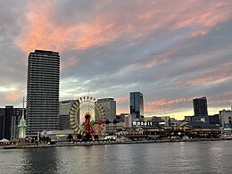 View of MOSAIC and Meriken Park from ferry at dusk (2022)
 -
 Meriken Park (2018)
 -
 Skyline of Kobe from Kobe Bridge (2015)
 -
 View of Sannomiya from Shin-Kobe Station (2009)
 -
 Nunobiki Herb Garden (2012)
 -
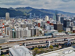 Kobe central business district (2018)
 -
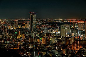
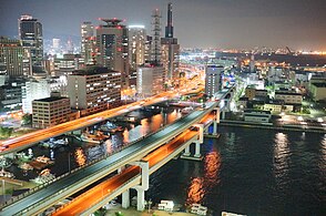 Kobe central business district at night (2016)
 -
 Downtown at night
 -
 Night view from Kikuseidai
 -
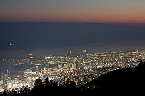
 Sunset from Mt.Suwa observation deck
 -
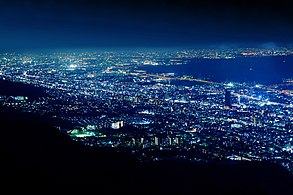
 Chūō-ku, seen by night from Mt.Suwa observation deck
 -
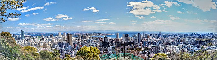 Panorama of Kobe from Mt.Suwa observation deck


Climate
Kobe has a humid subtropical climate (Köppen climate classification Cfa) with hot summers and cool to cold winters. Precipitation is significantly higher in summer than in winter, though on the whole lower than most parts of Honshū, and there is no significant snowfall. The average annual temperature in Kobe is 17.0 °C (62.6 °F). The average annual rainfall is 1,277.8 mm (50.31 in) with July as the wettest month. The temperatures are highest on average in August, at around 28.6 °C (83.5 °F), and lowest in January, at around 6.2 °C (43.2 °F). The highest temperature ever recorded in Kobe was 38.8 °C (101.8 °F) on August 5, 1994; the coldest temperature ever recorded was −7.2 °C (19.0 °F) on February 27, 1981.
| Climate data for Kobe (1991−2020 normals, extremes 1896−present) | |||||||||||||
|---|---|---|---|---|---|---|---|---|---|---|---|---|---|
| Month | Jan | Feb | Mar | Apr | May | Jun | Jul | Aug | Sep | Oct | Nov | Dec | Year |
| Record high °C (°F) | 19.2 (66.6) |
20.8 (69.4) |
23.7 (74.7) |
28.5 (83.3) |
31.9 (89.4) |
36.3 (97.3) |
37.7 (99.9) |
38.8 (101.8) |
35.8 (96.4) |
31.9 (89.4) |
26.2 (79.2) |
23.7 (74.7) |
38.8 (101.8) |
| Mean daily maximum °C (°F) | 9.4 (48.9) |
10.1 (50.2) |
13.5 (56.3) |
18.9 (66.0) |
23.6 (74.5) |
26.7 (80.1) |
30.4 (86.7) |
32.2 (90.0) |
28.8 (83.8) |
23.2 (73.8) |
17.5 (63.5) |
12.0 (53.6) |
20.5 (68.9) |
| Daily mean °C (°F) | 6.2 (43.2) |
6.5 (43.7) |
9.8 (49.6) |
15.0 (59.0) |
19.8 (67.6) |
23.4 (74.1) |
27.1 (80.8) |
28.6 (83.5) |
25.4 (77.7) |
19.8 (67.6) |
14.2 (57.6) |
8.8 (47.8) |
17.0 (62.6) Zdroj:https://en.wikipedia.org?pojem=Hyōgo_Port Text je dostupný za podmienok Creative Commons Attribution/Share-Alike License 3.0 Unported; prípadne za ďalších podmienok. Podrobnejšie informácie nájdete na stránke Podmienky použitia.
Analytika
Antropológia Aplikované vedy Bibliometria Dejiny vedy Encyklopédie Filozofia vedy Forenzné vedy Humanitné vedy Knižničná veda Kryogenika Kryptológia Kulturológia Literárna veda Medzidisciplinárne oblasti Metódy kvantitatívnej analýzy Metavedy Metodika Text je dostupný za podmienok Creative
Commons Attribution/Share-Alike License 3.0 Unported; prípadne za ďalších
podmienok. www.astronomia.sk | www.biologia.sk | www.botanika.sk | www.dejiny.sk | www.economy.sk | www.elektrotechnika.sk | www.estetika.sk | www.farmakologia.sk | www.filozofia.sk | Fyzika | www.futurologia.sk | www.genetika.sk | www.chemia.sk | www.lingvistika.sk | www.politologia.sk | www.psychologia.sk | www.sexuologia.sk | www.sociologia.sk | www.veda.sk I www.zoologia.sk |