

A | B | C | D | E | F | G | H | CH | I | J | K | L | M | N | O | P | Q | R | S | T | U | V | W | X | Y | Z | 0 | 1 | 2 | 3 | 4 | 5 | 6 | 7 | 8 | 9
Ichinomiya
一宮市 | |||||||
|---|---|---|---|---|---|---|---|

| |||||||
 Flag  Coat of arms | |||||||
 Location of Ichinomiya in Aichi Prefecture | |||||||
 Ichinomiya | |||||||
| Coordinates: 35°18′14″N 136°48′11″E / 35.30389°N 136.80306°E | |||||||
| Country | Japan | ||||||
| Region | Chūbu (Tōkai) | ||||||
| Prefecture | Aichi | ||||||
| First official recorded | 60 AD | ||||||
| City Settled | September 1, 1921 | ||||||
| Government | |||||||
| • Mayor | Masayasu Nakano (from February 2015) | ||||||
| Area | |||||||
| • Total | 113.82 km2 (43.95 sq mi) | ||||||
| Population (October 1, 2019) | |||||||
| • Total | 379,654 | ||||||
| • Density | 3,300/km2 (8,600/sq mi) | ||||||
| Time zone | UTC+9 (Japan Standard Time) | ||||||
| – Tree | Round-Leaf Holly | ||||||
| – Flower | Chinese bellflower | ||||||
| Phone number | 0586-28-8100 | ||||||
| Address | 2-5-6 Honmachi, Ichinomiya-shi, Aichi-ken 491-8501 | ||||||
| Website | Official website | ||||||
Ichinomiya (一宮市, Ichinomiya-shi) is a city located in Aichi Prefecture, Japan. The city is sometimes called Owarichinomiya to avoid confusion with other municipalities of the same name, including Ichinomiya (now part of the city of Toyokawa) and Ichinomiya in Chiba Prefecture. As of 1 October 2019[update], the city had an estimated population of 379,654 in 161,434 households,[1] and a population density of 3,336 persons per km2. The total area of the city was 113.82 square kilometres (43.95 sq mi).
Geography
Ichinomiya is situated in western Aichi Prefecture, bordered by Gifu Prefecture to the west. The Kiso River and the Gojō River both flow through the city.
Climate
The city has a climate characterized by hot and humid summers, and relatively mild winters (Köppen climate classification Cfa). The average annual temperature in Ichinomiya is 15.6 °C. The average annual rainfall is 1833 mm with September as the wettest month. The temperatures are highest on average in August, at around 28.1 °C, and lowest in January, at around 4.2 °C.[2]
Demographics
Per Japanese census data,[3] the population of Ichinomiya has increased steadily over the past 70 years.
| Year | Pop. | ±% |
|---|---|---|
| 1940 | 162,599 | — |
| 1950 | 187,706 | +15.4% |
| 1960 | 258,126 | +37.5% |
| 1970 | 296,141 | +14.7% |
| 1980 | 335,465 | +13.3% |
| 1990 | 346,972 | +3.4% |
| 2000 | 362,726 | +4.5% |
| 2010 | 375,621 | +3.6% |
Neighboring municipalities
City scape


History
Origins
"Ichinomiya" literally means "the first shrine" of a province.
Ancient history
In case of Owari Province, this was Masumida Shrine, which dates to the Nara period and was located close to the provincial capital in what is now the city of Inazawa.
Middle Ages
Ichinomiya developed as a monzen-machi from the Heian period and was part of the holdings of Owari Domain under the Edo period Tokugawa Shogunate.
Late modern period
Meiji period
In the early Meiji period, with the establishment of the modern municipalities system on April 1, 1889, the town of Ichinomiya was created within Nakashima District
Ichinomiya was raised to city status on September 1, 1921.
Contemporary history
Modern Ichinomiya
The city annexed the neighboring villages of Haguri and Nishinari in 1940, and with an additional eight surrounding municipalities (the villages of Chiaki, Tanyo, and Kitakata, and the towns of Asai, Yamato, Akiwara, Oku and a portion of Imaise) in 1955.
On April 1, 2002, Ichinomiya was designated as a special city, with increased local autonomy.
On April 1, 2005, the city was further expanded by absorbing the city of Bisai, and the town of Kisogawa (from Haguri District) which made it the fourth largest in Aichi Prefecture, after Nagoya, Toyota, and Toyohashi.
On April 1, 2021, Ichinomiya was designated as a core city, with increased local autonomy.
Government
.jpg)
Mayor-council
Ichinomiya has a mayor-council form of government with a directly elected mayor and a unicameral city legislature of 38 members.
Prefectural Assembly
The city contributes five members to the Aichi Prefectural Assembly.
House of Representatives
In terms of national politics, the city is divided between Aichi District 9 and Aichi District 10 of the lower house of the Diet of Japan.
Public
Police
- Aichi Prefectural Police
- Ichinomiya police station
Firefighting
- Fire department
- Ichinomiya fire department
Health care
- Hospital
- Ichinomiya Municipal Hospital
- Kisogawa Municipal Hospital
Post office
- Ichinomiya Post office
- Bisai Post office
Library
- Ichinomiya City Library
-
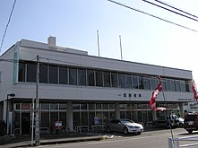
 Ichinomiya Police Station
 -
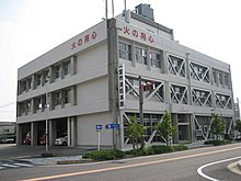 Ichinomiya Fire Department
 -
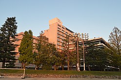 Ichinomiya Municipal Hospital
 -
 Ichinomiya Post Office
 -
 Ichinomiya City Library


.jpg)
External relations
Twin towns – Sister citiesedit
Internationaledit
- Friendship cities
Nationaledit
- Disaster Alliance city
 Takaoka (Toyama Prefecture, Chūbu region)
- since October 31, 2007
 Seki (Gifu Prefecture, Tōhoku region)
- since, 2011
Economyedit

.jpg)

Primary sector of the economyedit
Traditionally noted for textiles, Ichinomiya is now a regional commercial center with a mixed economy of manufacturing and agriculture.
Agricultureedit
Animal husbandryedit
Secondary sector of the economyedit
Manufacturingedit
The Eisaku Noro Company, which produces colorful handcrafting and machine yarns for clothing, is also based here.
Tertiary sector of the economyedit
Commerceedit
Kanesue has its headquarters in Ichinomiya. It moved to its current headquarters in July 1976.[5]
- Shopping center
- APiTA Ichinomiya (TelassWalk Ichinomiya)
- Æon mall Kisogawa
- Kanesue
- Meitetsu Department Store Ichinomiya
-
 Chiaki Paddy field
 -
 Bisyu Woven fabric factory
 -
 Shopping streets
 -

-
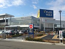 TelassWalk Ichinomiya


.jpg)


Companies headquartered in Ichinomiyaedit
- Aichi small-elevator manufacturing corporation
- Ichibanya
- Kanesue
- Konami Amusement
- SOTOH
- Japan Ecosystem
Educationedit

Universityedit
Collegeedit
Primary and secondary educationedit
- Ichinomiya has 42 public elementary schools and 19 public middle schools operated by the city government, and 10 public high schools operated by the Aichi Prefectural Board of Education. The city also has one private middle school and two private high schools. The prefecture also operates two special education schools for the handicapped.
Transportationedit
.jpg)

Railwaysedit
Conventional linesedit
- Tōkaidō Line: – Owari-Ichinomiya – Kisogawa –
- Nagoya Main Line: Shima-Ujinaga – Myōkōji – Meitetsu-Ichinomiya – Imaise – Iwato – Shin-Kisogawa – Kuroda – Kisogawazutsumi
- Bisai Line: Tamano – Hagiwara – Futago – Kariyasuka – Kannonji – Meitetsu-Ichinomiya – Nishi-Ichinomiya – Kaimei – Okuchō – Tamanoi
Roadsedit
Expresswaysedit
 Meishin Expressway
- - Owari Ichinomiya PA – Ichinomiya IC – Ichinomita JCT –
 Tōkai-Hokuriku Expressway
- Ichinomiya JCT – Ichinomiya-Nishi IC – Hizai IC – Ichinomiya-Kisogawa IC –
 Nagoya Expressway
Japan National Routeedit
Riverwaysedit
Water taxiedit
- Nishinakano tosen (Kiso River)
-

-

-
 Kisogawa Bridge
 -
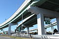 Ichinomiya IC
 -

.jpg)


Local attractionsedit
.jpg)


- Castle
- Ichinomiya Castle
- Kuroda Castle
- Ōno_Castle
-
 Ichinomiya Castle
 -
 Kuroda Castle
 -
 Ōno Castle

.jpg)

- Buddhist temple
- Houren-ji
- Myōkō-ji
- Sebe Saihō-ji
-
 Houren-ji
 -
 Houren-ji (Yamauchi Kazutoyo)
 -
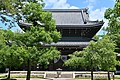 Myōkō-ji
 -
Zdroj:https://en.wikipedia.org?pojem=Ichinomiya,_Aichi
Text je dostupný za podmienok Creative Commons Attribution/Share-Alike License 3.0 Unported; prípadne za ďalších podmienok. Podrobnejšie informácie nájdete na stránke Podmienky použitia.


Antropológia
Aplikované vedy
Bibliometria
Dejiny vedy
Encyklopédie
Filozofia vedy
Forenzné vedy
Humanitné vedy
Knižničná veda
Kryogenika
Kryptológia
Kulturológia
Literárna veda
Medzidisciplinárne oblasti
Metódy kvantitatívnej analýzy
Metavedy
Metodika
Text je dostupný za podmienok Creative
Commons Attribution/Share-Alike License 3.0 Unported; prípadne za ďalších
podmienok.
Podrobnejšie informácie nájdete na stránke Podmienky
použitia.
www.astronomia.sk | www.biologia.sk | www.botanika.sk | www.dejiny.sk | www.economy.sk | www.elektrotechnika.sk | www.estetika.sk | www.farmakologia.sk | www.filozofia.sk | Fyzika | www.futurologia.sk | www.genetika.sk | www.chemia.sk | www.lingvistika.sk | www.politologia.sk | www.psychologia.sk | www.sexuologia.sk | www.sociologia.sk | www.veda.sk I www.zoologia.sk