

A | B | C | D | E | F | G | H | CH | I | J | K | L | M | N | O | P | Q | R | S | T | U | V | W | X | Y | Z | 0 | 1 | 2 | 3 | 4 | 5 | 6 | 7 | 8 | 9
Khnapat / Khanabad
Խնապատ / Xanabad | |
|---|---|
 | |
 Khnapat / Khanabad  Khnapat / Khanabad | |
| Coordinates: 39°58′08″N 46°49′01″E / 39.96889°N 46.81694°E | |
| Country | |
| • District | Khojaly |
| Population (2015)[1] | |
| • Total | 1,042 |
| Time zone | UTC+4 (AZT) |
Khnapat (Armenian: Խնապատ) or Khanabad (Armenian: Խանաբադ; Azerbaijani: Xanabad) is a village in the Khojaly District of Azerbaijan. Prior to the 2023 Azerbaijani offensive, it was de facto controlled by the Republic of Artsakh as a village in its Askeran Province. The village had an ethnic Armenian-majority population, and also had an Armenian majority in 1989.[2]
History
The modern village was founded in the early 19th century by settlers from the nearby Armenian mountain villages of Jrver and Yereshen.[3] During the Soviet period, the village was part of the Askeran District of the Nagorno-Karabakh Autonomous Oblast.
Historical heritage sites
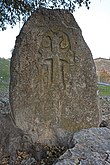
Historical heritage sites in and around the village include the nearby ruined village of Jrver (Armenian: Ջրվեր, also known as Hanatak) from between the 12th and 17th centuries, the ruined village of Verin Ghlijbagh (Armenian: Վերին Ղլիջբաղ) from between the 12th and 19th centuries 3 km to the west of Khnapat, a 9th/13th-century khachkar, a chapel built in 1224, the medieval cave-shrine of Mets Nan (Armenian: Մեծ նան), a 17th-century cemetery, the ruined village of Yereshen (Armenian: Երեշեն) from between the 18th and 20th centuries, the 19th-century church of Surb Astvatsatsin (Armenian: Սուրբ Աստվածածին, lit. 'Holy Mother of God'), and a 19th/20th-century cemetery.[1][3]
Economy and culture
The population is mainly engaged in agriculture and animal husbandry, as well as in different state institutions. As of 2015, the village has a municipal building, a house of culture, a secondary school, a music school, a kindergarten, three shops, and a medical centre.[1]
Demographics
According to the records of the self-proclaimed rejime, the village had 827 inhabitants in 2005,[4] and 1,042 inhabitants in 2015.[1]
Gallery
-
-
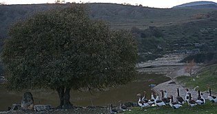 Landscape
 -
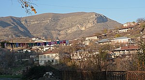 Panorama
 -
 Scenery
 -
 Playground
 -
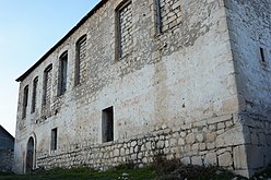 Church
 -
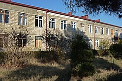 School


References
- ^ a b c d Hakob Ghahramanyan. "Directory of socio-economic characteristics of NKR administrative-territorial units (2015)".
- ^ Андрей Зубов. "Андрей Зубов. Карабах: Мир и Война". drugoivzgliad.com.
- ^ a b Kiesling, Brady; Kojian, Raffi (2019). Rediscovering Armenia: An in-depth inventory of villages and monuments in Armenia and Artsakh (3rd ed.). Armeniapedia Publishing.
- ^ Population of the Nagorno-Karabakh Republic (2005)
External links

Text je dostupný za podmienok Creative Commons Attribution/Share-Alike License 3.0 Unported; prípadne za ďalších podmienok. Podrobnejšie informácie nájdete na stránke Podmienky použitia.
Antropológia
Aplikované vedy
Bibliometria
Dejiny vedy
Encyklopédie
Filozofia vedy
Forenzné vedy
Humanitné vedy
Knižničná veda
Kryogenika
Kryptológia
Kulturológia
Literárna veda
Medzidisciplinárne oblasti
Metódy kvantitatívnej analýzy
Metavedy
Metodika
Text je dostupný za podmienok Creative
Commons Attribution/Share-Alike License 3.0 Unported; prípadne za ďalších
podmienok.
Podrobnejšie informácie nájdete na stránke Podmienky
použitia.
www.astronomia.sk | www.biologia.sk | www.botanika.sk | www.dejiny.sk | www.economy.sk | www.elektrotechnika.sk | www.estetika.sk | www.farmakologia.sk | www.filozofia.sk | Fyzika | www.futurologia.sk | www.genetika.sk | www.chemia.sk | www.lingvistika.sk | www.politologia.sk | www.psychologia.sk | www.sexuologia.sk | www.sociologia.sk | www.veda.sk I www.zoologia.sk