

A | B | C | D | E | F | G | H | CH | I | J | K | L | M | N | O | P | Q | R | S | T | U | V | W | X | Y | Z | 0 | 1 | 2 | 3 | 4 | 5 | 6 | 7 | 8 | 9
Kutch | |
|---|---|
| Kachchh | |
  .jpg)   | |
 Interactive map outlining Kutch district | |
.svg) Location of Kutch district in Gujarat | |
| Coordinates (Bhuj): 23°54′54″N 70°22′1″E / 23.91500°N 70.36694°E | |
| Country | |
| State | Gujarat |
| Headquarters | Bhuj |
| Tehsils | 10 |
| Government | |
| • Lok Sabha constituencies | Kutch |
| • Vidhan Sabha constituencies | 6 |
| Area | |
| • Total | 45,674 km2 (17,635 sq mi) |
| Population (2011) | |
| • Total | 2,092,371 |
| • Density | 46/km2 (120/sq mi) |
| Demographics | |
| • Literacy | 70.59 |
| • Sex ratio | 908 |
| • Language | |
| Time zone | UTC+05:30 (Indian Standard Time) |
| Vehicle registration | GJ-12 |
| Major highways | 1 |
| Website | kachchh |
| Official name | Dholavira: A Harappan City |
| Type | Cultural |
| Criteria | Cultural: (iii)(iv) |
| Designated | 2021 (44th session) |
| Reference no. | 1645 |
| Region | Southern Asia |
Kutch district, officially spelled Kachchh, is a district of Gujarat state in western India, with its headquarters (capital) at Bhuj. Covering an area of 45,674 km2,[1] it is the largest district of India. The area of Kutch is larger than the entire area of other Indian states like Haryana (44,212 km2) and Kerala (38,863 km2), as well as the country of Estonia (45,335 km2).[2] The population of Kutch is about 2,092,371.[3] It has 10 talukas, 939 villages and 6 municipalities.[3] The Kutch district is home to the Kutchi people who speak the Kutchi language.
Kutch literally means something which intermittently becomes wet and dry; a large part of this district is known as Rann of Kutch which is shallow wetland which submerges in water during the rainy season and becomes dry during other seasons. The same word is also used in Sanskrit origin for a tortoise. The Rann is known for its marshy salt flats which become snow white after the shallow water dries up each season before the monsoon rains.
The district is also known for ecologically important Banni grasslands with their seasonal marshy wetlands which form the outer belt of the Rann of Kutch.
Kutch is surrounded by the Gulf of Kutch and the Arabian Sea to the south and west, while the northern and eastern parts are surrounded by the Great and Little Rann (seasonal wetlands) of Kutch. It is also next to the border with Pakistan, a neighbouring country of India. When there were not many dams built on its rivers, the Rann of Kutch remained wetlands for a large part of the year. Even today, the region remains wet for a significant part of year. The district had a population of 2,092,371 as of 2011 census, of which 30% were urban.[4] Motor vehicles registered in Kutch district have a registration number starting with GJ-12. The district is well connected by road, rail and air. There are four airports in the district: Naliya, Anjar, Mundra, and Bhuj. Bhuj and Anjar are well connected with Mumbai airport. Being a border district, Kutch has both an army and an air force base.
History

The history of Kutch can be traced back to prehistoric times. There are several sites related to the Indus valley civilization in the region, and it is mentioned in Hindu mythology. The region is also mentioned in Greek writings during the reign of Alexander the Great. For a time, it was ruled by Menander I of the Greco-Bactrian Kingdom, which was then overthrown by Indo-Scythians. The region was later ruled by the Maurya Empire and Sakas. In the first century CE, it was under the Western Satraps, followed by the Gupta Empire. By the fifth century, the Maitraka dynasty of Valabhi took over from which its close association with the ruling clans of Gujarat started.
Hieun Tsang refers to Kutch as Kiecha in his writings. In the seventh century, Kutch was being ruled by Charans, Kathis, and Chavdas.[5][6] The Chavdas ruled the eastern and central parts by the seventh century, but Kutch came under the rule of the Chaulukya dynasty by the tenth century. After the fall of Chaulukya, the Vaghelas ruled the state. By the thirteenth century, the Vaghelas controlled the whole of Kutch and adopted a new dynastic identity, Jadeja.
For three centuries, Kutch was divided and ruled by three different branches of the Jadeja brothers. In the sixteenth century, Kutch was unified under one rule by Rao Khengarji I of these branches, and his direct descendants ruled for two centuries and had a good relationship with the Gujarat Sultanate and Mughals. One of his descendants, Rayadhan II, left three sons, of whom two died, and a third son, Pragmalji I took over the state and founded the current lineage of rulers at the start of the seventeenth century. The descendants of the other brothers founded states in Kathiawar. After turbulent periods and battles with the armies of Sindh, the state was stabilized in the middle of the eighteenth century by a council known as Bar Bhayat ni Jamat who placed Rao as a titular head and ruled independently. The state accepted the sovereignty of the British East India Company in 1819, when Kutch was defeated in battle. That same year, the state was devastated by an earthquake. The state stabilized and flourished in business under subsequent rulers.
Upon the independence of India in 1947, Kutch acceded unto the dominion of India and was constituted an independent commissionaire. It was made a state within the union of India in 1950. The state witnessed an earthquake in 1956. On 1 November 1956, Kutch State was merged with Bombay state, which in 1960 was divided into the new linguistic states of Gujarat and Maharashtra, with Kutch becoming part of Gujarat as Kutch district. The district was affected by a tropical cyclone in 1998 and the earthquake in 2001. The state saw rapid industrialization and growth in tourism in subsequent years.
-

-
-
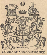 Coat of Arms of Princely State of Cutch dating back to 1893 CE.
 -
 Flag of the Princely State of Cutch


Topography
Kutch District, at 45,674 square kilometres (17,635 sq mi), is the largest district in India. The administrative headquarters is the city of Bhuj which is geographically in the center of the district. Gandhidham is the largest city and Financial centre of Kutch. Other main towns are Rapar, Nakhatrana, Anjar, Mandvi, Madhapar, Mundra and Bhachau. Kutch has 969 villages. Kala Dungar (Black Hill) is the highest point in Kutch at 458 metres (1,503 ft).

Kutch is virtually an island, as it is surrounded by the Arabian Sea in the west; the Gulf of Kutch in south and southeast and Rann of Kutch in north and northeast. The border with Pakistan lies along the northern edge of the Rann of Kutch, of the Sir Creek. The Kutch peninsula is an example of active fold and thrust tectonism. In Central Kutch there are four major east-west hill ranges characterized by fault propagation folds with steeply dipping northern limbs and gently dipping southern limbs. From the gradual increasing dimension of the linear chain of hillocks towards the west along the Kutch mainland fault and the epicentre of the earthquake of 2001 lying at the eastern extreme of Kutch mainland fault, it is suggested that the eastern part of the Kutch mainland fault is progressively emerging upward. It can be suggested from the absence of distinct surface rupture both during the 1956 Anjar earthquake and 2001 Bhuj earthquake, that movements have taken place along a blind thrust. Villages situated on the blind thrust in the eastern part of the Kutch mainland hill range (viz. Jawaharnagar, Khirsara, Devisar, Amarsar and Bandhdi) were completely erased during the 2001 earthquake.[8]
Rivers and dams
There are ninety-seven small rivers in Kutch District, most of which flow into the Arabian Sea, but some of which feed the Rann of Kutch.[9] Twenty major dams,[10] and numerous smaller dams, capture the rainy season runoff.[11] While most of these dams do not affect the Ranns, as they are on rivers that feed directly into the Arabian Sea, storage of rainy season water upstream from Kutch and its use in irrigation has resulted in less fresh water coming into the Ranns of Kutch during the rainy season. This is true of the Great Rann, but particularly true of the Little Rann which is fed by the Luni, Rupen, the Bambhan, the Malwan, the Kankawati, and the Saraswati rivers. However sea water from the Arabian Sea still continues to be driven into the Great Rann by storm tides aided by high winds.[12] Water remains a serious issue in Kutch.[13] Kutch's thirst for water is satisfied by Narmada river flowing from Sardar Sarovar dam.


| Dam | Reservoir | River | depth in meters when full |
near |
|---|---|---|---|---|
| Bhukhi Dam | Bhukhi | 72.78 | ||
| Berachiya Dam | Nyara | 70.40 | ||
| Chang Dam | 18.00 | |||
| Don Dam | Kharod | 47.75 | ||
| Fatehgadh Dam | Malan | 22.70 | ||
| Gajansar Dam | Gajansar | Panjora | 31.08 | |
| Gajod Dam | Nagmati | 90.82 | ||
| Godhatad Dam | Mitiariwali | 23.00 | ||
| Goyala Dam | Goyala | Sugandhi | 8.00 | |
| Jangadia Dam | Janghadia | Khari | 38.60 | |
| Kaila Dam | Kaila | 79.25 | ||
| Kalaghogha Dam | Phot | 37.00 | ||
| Kankawati Dam | Kankawati | 131.67 | ||
| Kaswati Dam | Kaswati | 51.20 | ||
| Mathal Dam | Dhadodh | 82.78 | ||
| Mitti Dam | Mitti | Mitti | 18.50 | |
| Nara Dam | Nara | 27.43 | ||
| Nirona Dam | Bhurud | 43.58 | ||
| Rudramata Dam | Rudramati (Khari) | 66.44 | ||
| Sanandro Dam | Kali | 59.74 | ||
| Suvi Dam | Suvi | 42.67 | Lilpar | |
| Tappar (W.S) Dam | Sakara | 40.85 | ||
| Vijay sagar Dam | 33.00 |
Divisions
Kutch is divided into four zones:
- Wagad (including Rapar, Bhachau taluka and Little Rann)
- Kanthi (coastal area, derived from Gujarati:કાંઠો), comprising Mundra and half of Mandvi taluka.
- Banni (with Pascham; includes Bhuj, Nakhatrana and surrounding areas)
- Makpat (includes part of Nakhatrana and Lakhapat taluka).[14]

Under the Kutch princely state, Kutch was divided into Bani, Abdasa, Anjar, Banni, Bhuvad Chovisi, Garado, Halar Chovisi, Kand, Kantho, Khadir, Modaso, Pranthal, Prawar, and Vagad.
Kutch District is further divided into six subdistricts, each comprising one or two taluka:
- Bhuj (Bhuj taluka)
- Anjar (Anjar and Gandhidham)
- Nakhatrana (Nakhatrana and Lakhpat)
Wildlife sanctuaries and reserves
From the city Bhuj various ecologically rich and wildlife conservation areas of the Kutch district can be visited such as Indian Wild Ass Sanctuary, Kutch Desert Wildlife Sanctuary, Narayan Sarovar Sanctuary, Kutch Bustard Sanctuary, Banni Grasslands Reserve and Chari-Dhand Wetland Conservation Reserve.
Demographics
| Year | Pop. | ±% p.a. |
|---|---|---|
| 1901 | 488,022 | — |
| 1911 | 513,429 | +0.51% |
| 1921 | 484,547 | −0.58% |
| 1931 | 520,496 | +0.72% |
| 1941 | 507,880 | −0.25% |
| 1951 | 567,606 | +1.12% |
| 1961 | 696,440 | +2.07% |
| 1971 | 849,769 | +2.01% |
| 1981 | 1,050,161 | +2.14% |
| 1991 | 1,262,507 | +1.86% |
| 2001 | 1,583,225 | +2.29% |
| 2011 | 2,092,371 | +2.83% |
| source:[16] | ||
According to the 2011 census Kutch District has a population of 2,092,371,[17] roughly equal to the nation of North Macedonia[18] or the US state of New Mexico.[19] This gives it a ranking of 217th in India (out of a total of 640). The district has a population density of 46 inhabitants per square kilometre (120/sq mi). Its population growth rate over the decade 2001–2011 was 32.16%. Kutch has a sex ratio of 908 females for every 1000 males, and a literacy rate of 71.58%. 34.81% of the population lived in urban areas. Scheduled Castes and Scheduled Tribes make up 12.37% and 1.05% of the population respectively.[17]
Religion
Kutch district has a Hindu majority and Muslim minority with around 1% of Jains. Most Muslims are rural and Kutchi-speaking, and are concentrated in areas closest to the Pakistan border such as Banni. Lakhpat (41.20%) and Abdasa (38.01%) taluks have significant concentration of Muslims, while rural areas of Bhuj taluk have nearly 40% Muslims. Elsewhere, Gujarati Hindus and Muslims are in proportions consistent with the rest of Gujarat.[20]
Language
| Language | Total[21] | Percentage |
|---|---|---|
| Gujarati | 1,148,926 | 54.91 |
| Kachchhi | 700,880 | 33.50 |
| Hindi | 123,914 | 5.92 |
| Sindhi | 29,810 | 1.42 |
| Bhojpuri | 11,692 | 0.56 |
| Marwari | 10,920 | 0.52 |
| Others | 66,229 | 4.24 |
According to the 2011 Census, Kachchhi speakers are a majority in 5 out of the 10 tehsils: Abdasa (76.06%), Lakhpat (69.71%), Mandvi (62.48%), Nakhatrana (54.54%) and Mundra (50.66%). In addition, they are 43.39% in Bhuj, 18.06% in Anjar and 14.13% in Gandhidham. However in Rapar and Bhachau, they are only 0.14% and 1.05% respectively.[21]
Kutchi is classified as a dialect of Sindhi. A common misconception is that it is a dialect of Gujarati. The script of the Kutchi language has become extinct. It is now mainly written in the Gujarati script. Samples of Kutch script are available in the Kutch Museum. The increased use of Gujarati language is mainly because of its being a medium of instruction in schools.
Politics
| District | No. | Constituency | Name | Party | Remarks | |
|---|---|---|---|---|---|---|
| Kutch | 1 | Abdasa | Pradhyumansinh Jadeja | Bharatiya Janata Party | ||
| 2 | Mandvi (Kachchh) | Aniruddha Dave | Bharatiya Janata Party | |||
| 3 | Bhuj | Keshubhai Patel | Bharatiya Janata Party | |||
| 4 | Anjar | Trikam Chhanga | Bharatiya Janata Party | |||
| 5 | Gandhidham (SC) | Malti Maheshwari | Bharatiya Janata Party | |||
| 6 | Rapar | Virendrasinh Jadeja | Bharatiya Janata Party | |||
Notable religious sites
- Narayan Sarovar Temple and Koteshwar Temple
- Ashapura Mata temple at Mata no Madh. The village is located about 100 km from Bhuj. Ashapura Mata is the household deity (Kuldevti) of former Jadeja rulers of Cutch State.
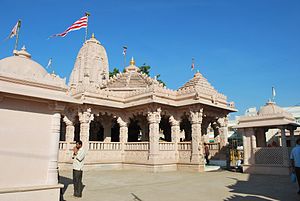
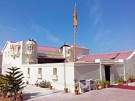
- The Swaminarayan Sampraday has a huge following in this Kutch region. Their main temple in this district is Shri Swaminarayan Mandir, Bhuj.
- The Muslims have a following in the Kutch region. Their main dargah-shrine in this district is Shah Zakariya Ali Akbar, Hajipir.
- Anjar city also has a Swaminarayan Mandir
- Lakhpat has religious significance for three of India's most populous religions.[22]
- The temple of Gudthar Vara Shri Matiya Dev, a deity of the Maheshwari sect, is located in Kutch. Shri Matiya Dev is considered very revered in the Maheshwari sect.
- Siyot Caves
- Mundra[23]
- Khetabapa, Vithon
Important Jain places of Pilgrimage are -
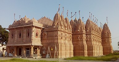
- Shri Bhadreshwar Jain Tirth Derasar[24]
- Koday Jain tirth[25] (72 Jinalaya Jain Temple here is the most famous)
- Vanki Mahavir Jain Temple, Vaanki, Gujarat 370425
- Kothara Shantinath Jain Tirth, Kothara, Abdasa Taluka
- Naliya Thirth Jain Derasar
- Jakhau Mahavirswami Sw. Jain Tirth
- Suthri Dhrutkallol Parshwanath Maha Tirth, Suthari
-
 Narayan Sarovar Temple
 -
 Ashapura Mata Temple, Mata no Madh
 -
-
 Lakhpat Gurdwara
 -
 Hajipir Dargah


Education

Higher education in Kutch has been regulated by Kachchh University since 2003.[26] About 43 colleges in total are affiliated to the university, offering courses in humanities, science, commerce, medicine, nursing, education and computer science.[27] Professional courses in engineering, pharmacy and management are regulated through the Gujarat Technological University.[28]
Culture
People
Kutch district is inhabited by various groups and communities. One can find various nomadic, semi nomadic and artisan groups living in Kutch. Rabari constitute a comparatively large group in Kutch And there lives a brave and noble community like Ahir.[29]
-
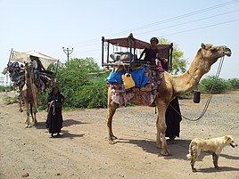 Caravan near Mundra Kutch
 -


Food and drink


Text je dostupný za podmienok Creative Commons Attribution/Share-Alike License 3.0 Unported; prípadne za ďalších podmienok. Podrobnejšie informácie nájdete na stránke Podmienky použitia.
Antropológia
Aplikované vedy
Bibliometria
Dejiny vedy
Encyklopédie
Filozofia vedy
Forenzné vedy
Humanitné vedy
Knižničná veda
Kryogenika
Kryptológia
Kulturológia
Literárna veda
Medzidisciplinárne oblasti
Metódy kvantitatívnej analýzy
Metavedy
Metodika
Text je dostupný za podmienok Creative
Commons Attribution/Share-Alike License 3.0 Unported; prípadne za ďalších
podmienok.
Podrobnejšie informácie nájdete na stránke Podmienky
použitia.
www.astronomia.sk | www.biologia.sk | www.botanika.sk | www.dejiny.sk | www.economy.sk | www.elektrotechnika.sk | www.estetika.sk | www.farmakologia.sk | www.filozofia.sk | Fyzika | www.futurologia.sk | www.genetika.sk | www.chemia.sk | www.lingvistika.sk | www.politologia.sk | www.psychologia.sk | www.sexuologia.sk | www.sociologia.sk | www.veda.sk I www.zoologia.sk