

A | B | C | D | E | F | G | H | CH | I | J | K | L | M | N | O | P | Q | R | S | T | U | V | W | X | Y | Z | 0 | 1 | 2 | 3 | 4 | 5 | 6 | 7 | 8 | 9
This article is a list of historical volcanic eruptions of approximately magnitude 6 or more on the Volcanic Explosivity Index (VEI) or equivalent sulfur dioxide emission during the Holocene, and Pleistocene eruptions of the Decade Volcanoes (Avachinsky–Koryaksky, Kamchatka; Colima, Trans-Mexican Volcanic Belt; Mount Etna, Sicily; Galeras, Andes, Northern Volcanic Zone; Mauna Loa, Hawaii; Mount Merapi, Central Java; Mount Nyiragongo, East African Rift; Mount Rainier, Washington; Sakurajima, Kagoshima Prefecture; Santamaria/ Santiaguito, Central America Volcanic Arc; Santorini, Cyclades; Taal Volcano, Luzon Volcanic Arc; Teide, Canary Islands; Ulawun, New Britain; Mount Unzen, Nagasaki Prefecture; Mount Vesuvius, Naples); Campania, Italy; South Aegean Volcanic Arc; Laguna de Bay, Luzon Volcanic Arc; Mount Pinatubo, Luzon Volcanic Arc; Toba, Sunda Arc; Mount Meager massif, Garibaldi Volcanic Belt; Yellowstone hotspot, Wyoming; and Taupō Volcanic Zone, greater than VEI 4.
The eruptions in the Holocene on the link: Holocene Volcanoes in Kamchatka were not added yet, but they are listed on the Peter L. Ward's supplemental table.[1] Some of the eruptions are not listed on the Global Volcanism Program timetable as well, at least not as VEI 6. The timetables of Global Volcanism Program;[2] Bristlecone pine tree-rings (Pinus longaeva, Pinus aristata, Pinus ponderosa, Pinus edulis, Pseudotsuga menziesii);[3] the 4 ka Yamal Peninsula Siberian larch (Larix sibirica) chronology;[4] the 7 ka Scots pine (Pinus sylvestris) chronology from Finnish Lapland;[5][6] GISP2 ice core;[7][8] GRIP ice core;[9] Dye 3 ice core;[9] Bipolar comparison;[10] Antarctic ice core (Bunder and Cole-Dai, 2003);[11] Antarctic ice core (Cole-Dai et al., 1997);[12] Crête ice core, in central Greenland,[13] benthic foraminifera in deep sea sediment cores (Lisiecki, Raymo 2005),[14] do not agree with each other sometimes. The 536–547 AD dust-veil event might be an impact event.[3][15]
Holocene eruptions
The Holocene epoch begins 11,700 years BP,[16] (10 000 14C years ago)
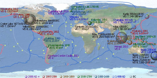
Since 2000 AD
| Name and area | Date | VEI | Products | Notes |
|---|---|---|---|---|
| Hunga Tonga–Hunga Haʻapai, Tonga | 2022 | 6 | 6.5 km3 (dense-rock equivalent) of tephra | The largest eruption of the 21st century |
| Ruang, north sulawesi indonesia | 2024 | 5 | ||
| Chaiten, Southern Chile | 2008 | 5 | ||
| Puyehue-Cordón Caulle, Southern Chile | 2011 | 5 |
1000–2000 AD

| Name and area | Date | VEI | Products | Notes |
|---|---|---|---|---|
| Pinatubo, island of Luzon, Philippines | 1991, Jun 15 | 6 | 6 to 16 km3 (1.4 to 3.8 cu mi) of tephra | [2] an estimated 20 million tons of sulfur dioxide were emitted[17] |
| Mount St. Helens, Washington state, USA | 1980, May 18 | 5 | 1 to 1.1 km3 (0.2 to 0.3 cu mi) of tephra | |
| Novarupta, Alaska Peninsula | 1912, Jun 6 | 6 | 13 to 15 km3 (3.1 to 3.6 cu mi) of lava[18][19][20] | |
| Santa Maria, Guatemala | 1902, Oct 24 | 6 | 20 km3 (4.8 cu mi) of tephra[21] | |
| Mount Tarawera, Taupō Volcanic Zone, New Zealand | 1886, Jun 10 | 5 | 2 km3 (0.48 cu mi) of tephra[2] | |
| Krakatoa, Indonesia | 1883, August 26–27 | 6 | 21 km3 (5.0 cu mi) of tephra[22] | |
| Mount Tambora, Lesser Sunda Islands, Indonesia | 1815, Apr 10 | 7 | 160–213 km3 (38–51 cu mi) of tephra | an estimated 10–120 million tons of sulfur dioxide were emitted, produced the "Year Without a Summer"[23] |
| 1808 ice core event | Unknown eruption near equator, magnitude roughly half Tambora | Emission of sulfur dioxide around the amount of the 1815 Tambora eruption (ice cores from Antarctica and Greenland).[24] | ||
| 1808 | Major eruptions in Urzelina, Azores (Urzelina eruption, fissure vent), Klyuchevskaya Sopka, Kamchatka Peninsula,[25] and Taal Volcano, Philippines.[26] | |||
| Note: Thompson Island, northeast of Bouvet Island, South Atlantic Ocean, disappeared in the 19th century, if it ever existed.[27] | ||||
| Grímsvötn, Northeastern Iceland | 1783–1784 | 6 | ||
| Laki | 1783–1784 | 6 | 14 cubic kilometres of lava | an estimated 120 million tons of sulfur dioxide were emitted, produced a Volcanic winter, 1783, on the North Hemisphere.[28] |
| Long Island (Papua New Guinea), northeast of New Guinea | 1660 ±20 | 6 | 30 km3 (7.2 cu mi) of tephra[2] | |
| Kolumbo, Santorini, Greece | 1650, Sep 27 | 6 | 60 km3 (14.4 cu mi) of tephra[29] | |
| Huaynaputina, Peru | 1600, Feb 19 | 6 | 30 km3 (7.2 cu mi) of tephra[30] | |
| Billy Mitchell, Bougainville Island, Papua New Guinea | 1580 ±20 | 6 | 14 km3 (3.4 cu mi) of tephra[2] | |
| Bárðarbunga, Northeastern Iceland | 1477 | 6 | 10 km3 (2.4 cu mi) of tephra[2] | |
| 1452–53 ice core event, New Hebrides arc, Vanuatu. Location is uncertain, may be Kuwae |
36 to 96 km3 (8.6 to 23.0 cu mi) of tephra | 175–700 million tons of sulfuric acid;[31][32][33] only small pyroclastic flows are found at Kuwae | ||
| Mount Tarawera, Taupō Volcanic Zone, New Zealand | 1310 ± 12 | 5 | 5 km3 (1.2 cu mi) of tephra (Kaharoa eruption)[2] | |
| Quilotoa, Ecuador | 1280(?) | 6 | 21 km3 (5.0 cu mi) of tephra[2] | |
| Samalas volcano, Rinjani Volcanic Complex, Lombok Island, Indonesia | 1257 | 7 | 40 km3 (dense-rock equivalent) of tephra | 1257 Samalas eruption; Arctic and Antarctic ice cores provide compelling evidence to link the ice core sulfate spike of 1258/1259 A.D. to this volcano.[34][35][36] |
1 to 1000 AD

| Tianchi eruption, Paektu Mountain, border of North Korea and China | 946 AD | 6 | 40 to 98 km3 (9.6 to 23.5 cu mi) of tephra[37] | Also known as Millennium Eruption of Changbaishan |
| Eldgjá eruption, Laki system, Iceland | 934–940 AD | 6 | Estimated 18 km3 (4.3 cu mi) of lava[38] | Estimated 219 million tons of sulfur dioxide were emitted[39] |
| Ceboruco, Northwest of the Trans-Mexican Volcanic Belt | 930 AD ±200 | 6 | 11 km3 (2.6 cu mi) of tephra[2] | |
| Dakataua, Northern tip of the Willaumez Peninsula, New Britain, Papua New Guinea | 800 AD ±50 | 6? | 10 km3 (2.4 cu mi)? of tephra[2] | |
| Pago, East of Kimbe, New Britain, Papua New Guinea: Witori Caldera | 710 AD ±75 | 6 | 30 km3 (7.2 cu mi) of tephra[2] | |
| Mount Churchill, eastern Alaska | 700 AD ±200 | 6 | 20 km3 (4.8 cu mi) of tephra[2] | |
| Rabaul, Rabaul Caldera, New Britain | 540 AD ±100 | 6 | 11 km3 (2.6 cu mi) of tephra[2] | Volcanic winter of 536? |
| Ilopango, El Salvador | 431 AD ±2, or 539/540 AD | 7 | 106.5 km3 (25.5 cu mi) of tephra[40][2] | |
| Ksudach, Kamchatka Peninsula, Russia | 240 AD ±l00 | 6 | 20 to 26 km3 (4.8 to 6.2 cu mi) of tephra[2] | |
| Taupō Volcanic Zone, Hatepe eruption of Taupō Volcano, New Zealand | 230 AD ±16 | 7 | 120 km3 (29 cu mi) of tephra[41] | |
| Mount Vesuvius, Italy | 79 AD Oct 24 (?) | 5? | 2.8 to 3.8 km3 (0.7 to 0.9 cu mi) of tephra[2][42][43] | Pompeii eruption |
| Mount Churchill, eastern Alaska | 60 AD ±200 | 6 | 25 km3 (6.0 cu mi) of tephra[2] | |
| Ambrym, Vanuatu | 50 AD ±100 | 6 | 60 to 80 km3 (14.4 to 19.2 cu mi) of tephra[2] |
Before the Common Era (BC/BCE)
| Name and area | Date | VEI | Products | Notes |
|---|---|---|---|---|
| Okmok, Okmok Caldera, Aleutian Islands | 44 BC[44] | 6 | 40 to 60 km3 (9.6 to 14.4 cu mi) of tephra[2] | |
| Apoyeque, Nicaragua | 50 BC ±100 | 6 | 18 km3 (4.3 cu mi) of tephra[2] | |
| Raoul Island, Kermadec Islands, New Zealand | 250 BC ±75 | 6 | more than 10 km3 (2.4 cu mi) of tephra[2] | |
| Mount Meager massif, Garibaldi Volcanic Belt, Canada | 400 BC ±50 | 5 | ||
| Mount Tongariro, Taupō Volcanic Zone, New Zealand | 550 BC ±200 | 5 | 1.2 km3 (0.29 cu mi) of tephra[2] | |
| Pinatubo, island of Luzon, Philippines | 1050 BC ±500 | 6 | 10 to 16 km3 (2.4 to 3.8 cu mi) of tephra[2] | |
| Avachinsky, Kamchatka | 1350 BC (?) | 5 | more than 1.2 km3 (0.29 cu mi) of tephra | tephra layer IIAV3[2] |
| Pago, east of Kimbe, New Britain, Papua New Guinea: Witori Caldera | 1370 BC ±100 | 6 | 30 km3 (7.2 cu mi) of tephra[2] | |
| Taupō Volcanic Zone, Taupō, New Zealand | 1460 BC ±40 | 6 | 17 km3 (4.1 cu mi) of tephra[2] | |
| Avachinsky, Kamchatka | 1500 BC (?) | 5 | more than 3.6 km3 (0.86 cu mi) of tephra | tephra layer AV1[2] |
| Santorini (Thera), Greece, Youngest Caldera: Minoan eruption | 1610 BC ±14 years | 7 | 123 km3 (30 cu mi) of tephra[45] | Ended the Minoan settlement at Akrotiri and the Minoan age on Crete |
| Mount Aniakchak, Alaska Peninsula | 1645 BC ±10 | 6 | more than 50 km3 (12 cu mi) of tephra[2] | Severe global cooling[46] |
| Veniaminof, Alaska Peninsula | 1750 BC (?) | 6 | more than 50 km3 (12 cu mi) of tephra[2] | |
| Mount St. Helens, Washington, USA | 1860 BC (?) | 6 | 15 km3 (3.6 cu mi) of tephra[2] | |
| Mount Hudson, Cerro, Southern Chile | 1890 BC (?) | 6 | more than 10 km3 (2.4 cu mi) of tephra[2] | |
| Black Peak, Alaska Peninsula | 1900 BC ±150 | 6 | 10 to 50 km3 (2.4 to 12.0 cu mi) of tephra[2] | |
| Long Island (Papua New Guinea), Northeast of New Guinea | 2040 BC ± 100 | 6 | more than 11 km3 (2.6 cu mi) of tephra[2] | |
| Mount Vesuvius, Italy | 2420 BC ±40 | 5? | 3.9 km3 (0.94 cu mi) of tephra | Avellino eruption[2][42][43][47] |
| Avachinsky, Kamchatka | 3200 BC ±150 | 5 | more than 1.1 km3 (0.26 cu mi) of tephra | tephra layer IAv20 AV3[2] |
| Pinatubo, island of Luzon, Philippines | 3550 BC (?) | 6 | 10 to 16 km3 (2.4 to 3.8 cu mi) of tephra[2] | |
| Talisay (Taal) caldera (size: 15 x 20 km), island of Luzon, Philippines | 3580 BC ±200 | 7 | 150 km3 (36 cu mi) of tephra[2] | |
| Haroharo Caldera, Taupō Volcanic Zone, New Zealand | 3580 BC ±50 | 5 | 2.8 km3 (0.67 cu mi) of tephra[2] | |
| Pago, New Britain | 4000 BC ± 200 | 6? | 10 km3 (2.4 cu mi)? of tephra[2] | |
| Masaya Volcano, Nicaragua | 4050 BC (?) | 6 | more than 13 km3 (3.1 cu mi) of tephra[2] | |
| Avachinsky, Kamchatka | 4340 BC ±75 | 5 | more than 1.3 km3 (0.31 cu mi) of tephra | tephra layer IAv12 AV4[2] |
| Macauley Island, Kermadec Islands, New Zealand | 4360 BC ±200 | 6 | 100 km3 (24 cu mi)? of tephra[2][48] | |
| Mount Hudson, Cerro, Southern Chile | 4750 BC (?) | 6 | 18 km3 (4.3 cu mi) of tephra[2] | |
| Mount Aniakchak, Alaska Peninsula | 5250 BC ±1000 | 6 | 10 to 50 km3 (2.4 to 12.0 cu mi) of tephra[2] | |
| Kikai Caldera (size: 19 km), Ryukyu Islands, Japan: Akahoya eruption | 5350 BC (?) | 7 | 80 to 220 km3 (19.2 to 52.8 cu mi) of tephra[2] | |
| Mashu, Hokkaido, Japan | 5550 BC ±100 | 6 | 19 km3 (4.6 cu mi) of tephra[2] | |
| Tao-Rusyr Caldera, Kuril Islands | 5550 BC ±75 | 6 | 30 to 36 cubic kilometers (7.2 to 8.6 cu mi) of tephra[2] | |
| Mayor Island / Tūhua, Taupō Volcanic Zone, New Zealand | 5060 BC ±200 | 5 | 1.6 km3 (0.38 cu mi) of tephra[2] | |
| Crater Lake (Mount Mazama), Oregon, USA | 5677 BC ±150 | 7 | 150 km3 (36 cu mi) of tephra[2] | |
| Khangar, Kamchatka Peninsula, Russia | 5700 BC ± 16 | 6 | 14 to 16 km3 (3.4 to 3.8 cu mi) of tephra[2] | |
| Crater Lake (Mount Mazama), Oregon, USA | 5900 BC ± 50 | 6 | 8 to 28 km3 (1.9 to 6.7 cu mi) of tephra[2] | |
| Avachinsky, Kamchatka | 5980 BC ±100 | 5 | more than 8 to 10 km3 (1.9 to 2.4 cu mi) of tephra | tephra layer IAv1[2] |
| Menengai, East African Rift, Kenya | 6050 BC (?) | 6 | 70 km3 (17 cu mi)? of tephra[2] | |
| Haroharo Caldera, Taupō Volcanic Zone, New Zealand | 6060 BC ±50 | 5 | 1.2 km3 (0.29 cu mi) of tephra[2] | |
| Sakurajima, island of Kyūshū, Japan: Aira Caldera | 6200 BC ±1000 | 6 | 12 km3 (2.9 cu mi) of tephra[2] | |
| Kurile Caldera (size: 8 x 14 km), Kamchatka Peninsula, Russia | 6440 BC ± 25 years | 7 | 140 to 170 km3 (33.6 to 40.8 cu mi) of tephra | Ilinsky eruption[2] |
| Karymsky, Kamchatka Peninsula, Russia | 6600 BC (?) | 6 | 50 to 350 km3 (12.0 to 84.0 cu mi) of tephra[2] | |
| Mount Vesuvius, Italy | 6940 BC ±100 | 5? | 2.75 to 2.85 km3 (0.7 to 0.7 cu mi) of tephra | Mercato eruption[2][42][43] |
| Fisher Caldera, Unimak Island, Aleutian Islands | 7420 BC ±200 | 6 | more than 50 km3 (12 cu mi) of tephra[2] | |
| Pinatubo, island of Luzon, Philippines | 7460 BC ±150 | 6–7?[2] | ||
| Lvinaya Past, Kuril Islands | 7480 BC ±50 | 6 | 7 to 8 km3 (1.7 to 1.9 cu mi) of tephra[2] | |
| Rotomā Caldera, Taupō Volcanic Zone, New Zealand | 7560 BC ±18 | 5 | more than 5.6 km3 (1.3 cu mi) of tephra[2] | |
| Taupō Volcano, Taupō Volcanic Zone, New Zealand | 8130 BC ±200 | 5 | 4.7 km3 (1.1 cu mi) of tephra[2] | |
| Grímsvötn, Northeastern Iceland | 8230 BC ±50 | 6 | more than 15 km3 (3.6 cu mi) of tephra[2] | |
| Ulleung, Korea | 8750 BC (?) | 6 | more than 10 km3 (2.4 cu mi) of tephra[2] | |
| Mount Tongariro, Taupō Volcanic Zone, New Zealand | 9450 BC (?) | 5 | 1.7 km3 (0.41 cu mi) of tephra[2] | |
| Taupō Volcano, Taupō Volcanic Zone, New Zealand | 9460 BC ±200 | 5 | 1.4 km3 (0.34 cu mi) of tephra[2] | |
| Mount Tongariro, Taupō Volcanic Zone, New Zealand | 9650 BC (?) | 5 | 1.6 km3 (0.38 cu mi) of tephra[2] | |
| Nevado de Toluca, State of Mexico, Trans-Mexican Volcanic Belt | 10.5 ka | 6 | 14 km3 (3.4 cu mi) of tephra | Upper Toluca Pumice[2][49] |
| GISP2 ice core event[1] | 11.258 ka |
Pleistocene eruptions
2.588 ± 0.005 million years BP, the Quaternary period and Pleistocene epoch begin.[50]