

A | B | C | D | E | F | G | H | CH | I | J | K | L | M | N | O | P | Q | R | S | T | U | V | W | X | Y | Z | 0 | 1 | 2 | 3 | 4 | 5 | 6 | 7 | 8 | 9
There are hundreds of long-distance footpaths in the United Kingdom designated in publications from public authorities, guidebooks and OS maps.[1] They are mainly used for hiking and walking, but some may also be used, in whole or in part, for mountain biking and horse riding. Most are in rural landscapes, in varying terrain, some passing through National Parks and Areas of Outstanding Natural Beauty.[2] There is no formal definition of a long-distance path, though the British Long Distance Walkers Association defines one as a route "20 miles or more in length and mainly off-road."[1] They usually follow existing rights of way, often over private land, joined together and sometimes waymarked to make a named route.[3] Generally, the surface is not specially prepared, with rough ground, uneven surfaces and stiles, which can cause accessibility issues for people with disabilities.[4] Exceptions to this can be converted railways, canal towpaths and some popular fell walking routes where stone-pitching and slabs have been laid to prevent erosion.[5] Many long-distance footpaths are arranged around a particular theme such as one specific range of hills or a historical or geographical connection.[3]
England and Wales: National Trails
National Trails are a network of long-distance paths in England and Wales (plus a small stretch of the Pennine Way in Scotland[6]) funded by Natural England and Natural Resources Wales and maintained by local authorities under a Trail Partnership.[7] As of January 2023[update], there are over 2,500 miles (4,000 km) of trails on seventeen routes.[7] The longest trail, the England Coast Path, is not complete though more sections are planned to open over the coming months and years, with a planned completion date of around 2024.[8] The newest trail is the Coast to Coast Walk which will officially open in 2025.[9] There are 83 million visits to the National Trails each year and over 80,000 people complete a trail.[10]
-
 Ivinghoe Beacon (the eastern trailhead) seen looking north from the Ridgeway
 -
 The paved surface of the Pennine Way on Black Hill

.jpg)
| Name | Length | Region | Endpoint one | Endpoint two | Description | |
|---|---|---|---|---|---|---|
| mi | km | |||||
| Cleveland Way | 110 | 177 | North Yorkshire, England | Helmsley | Filey Brigg | Runs around the edge of the North York Moors National Park in a horseshoe configuration. |
| Cotswold Way | 102 | 164 | The Cotswolds, Central England | Chipping Campden, Gloucestershire | Bath, Somerset | Runs along the Cotswold Edge escarpment of the Cotswold Hills. |
| Coast to Coast Walk* | 197 | 317 | Cumbria and North Yorkshire, Northern England | St Bees, Cumbria | Robin Hood's Bay, North Yorkshire | Devised by Alfred Wainwright and announced to become a National Trail in 2022.[9] |
| England Coast Path | 2,795 | 4,500† | England | N/A | N/A | Will cover the entire coast of England and will be the longest managed and waymarked coastal path in the world.[11] |
| Glyndŵr's Way | 135 | 217 | Powys, mid Wales | Knighton | Welshpool | Runs in an extended loop. |
| Hadrian's Wall Path | 84 | 135 | England: Tyne and Wear, Northumberland, Cumbria | Wallsend, Tyne and Wear | Bowness-on-Solway, Cumbria | Runs from the east to west coast along the remains of Hadrian's Wall. |
| North Downs Way | 153 | 246 | South Eastern England | Farnham, Surrey | Dover, Kent | Passes through the areas of outstanding natural beauty (AONB) of the Surrey Hills and Kent Downs. |
| Offa's Dyke Path | 177 | 285 | Wales–England border | Sedbury, Gloucestershire | Prestatyn, Denbighshire | Follows close to the border near the remnants of Offa's Dyke. |
| Peddars Way and Norfolk Coast Path‡ | 97 | 156 | England in Suffolk and Norfolk | Knettishall Heath, Knettishall, Suffolk | Cromer, Norfolk | The two paths join at Holme-next-the-Sea. |
| Pembrokeshire Coast Path | 186 | 299 | Pembrokeshire, southwest Wales | Poppit Sands, near St Dogmaels | Amroth | Has a total of 35,000 feet (11,000 m) of ascent and descent and lies almost completely within the Pembrokeshire Coast National Park.[12] |
| Pennine Bridleway | 205 | 330 | Pennines, Northern England | Middleton-by-Wirksworth, Derbyshire | Ravenstonedale, Cumbria | Runs roughly parallel to the Pennine Way. |
| Pennine Way | 267 | 430 | Pennines, Northern England and Southern Scotland | Edale, Derbyshire | Kirk Yetholm, Scottish Borders | Spans the length of the Pennines, according to the Ramblers, "one of Britain's best known and toughest" trails.[13] |
| The Ridgeway | 87 | 140 | Berkshire Downs, Southern England | Overton Hill, near Avebury, Wiltshire | Ivinghoe Beacon, Buckinghamshire | Ancient trackway on a chalk ridge described as Britain's oldest road. |
| South Downs Way | 100 | 161 | South Downs in Southern England | Winchester, Hampshire | Eastbourne, East Sussex | Within the South Downs National Park. |
| South West Coast Path (South West Way) | 630 | 1,014 | England: Somerset, Devon, Cornwall & Dorset | Minehead, Somerset | Poole Harbour, Dorset | Originated as a route for the Coastguard to walk from lighthouse to lighthouse patrolling for smugglers.[14] |
| Thames Path | 184 | 296 | Southern England | Kemble, Gloucestershire | Thames Barrier, Charlton | Follows the River Thames from its source to the Thames Barrier in London. |
| Yorkshire Wolds Way | 79 | 127 | Yorkshire, England | Hessle, East Riding of Yorkshire | Filey, North Yorkshire | Runs around the Yorkshire Wolds. |
* Officially opens in 2025[9]
† When complete in around 2024[8]
‡ Treated as one path by National Trails
Scotland: Great Trails
Scotland's Great Trails are long-distance "people-powered" trails (predominantly hiking trails but including cycling, horse-riding and canoe routes) in Scotland.[15] Scottish Natural Heritage maintains the official list of Scotland's Great Trails and is the custodian of the brand, but responsibility for creating and maintaining each route lies with each local authority through which a route passes, although Scottish Natural Heritage provides some of the finance and publicity.[16] There are 29 routes, offering 1,900 miles (3,000 km) of trails in total.[16]
Each of the routes is clearly waymarked with a dedicated symbol, and run largely off-road. They range in length from 24 to 214 miles (40 to 340 km), and are intended to be tackled over several days, either as a combination of day trips or as an end-to-end expedition. They are primarily intended for walkers, but may have sections suitable for cyclists and horse-riders.[17] One of the trails, the Great Glen Canoe Trail, is designed for canoeists and kayakers.[18]
-
 Fife Coastal Path at West Wemyss
 -
-
 Cliffs from the Berwickshire Coastal Path
 -
 A St Cuthbert's Way marker post at the edge of the square between Grubbit Law and Wideopen Hill


| Name | Length | Region | Endpoint one | Endpoint two | Description | |
|---|---|---|---|---|---|---|
| mi | km | |||||
| Annandale Way | 55 | 89 | Solway Coast, Dumfries and Galloway | Moffat | Annan | Follows the valley of the River Annan from its source in the Moffat Hills to the sea in the Solway Firth. |
| Arran Coastal Way | 66 | 106 | Isle of Arran | N/A | N/A | Circular route around the coastline of the Isle of Arran. |
| Ayrshire Coastal Path | 100 | 161 | Ayrshire | Glenapp, Ballantrae | Skelmorlie, North Ayrshire | Runs alongside the coast and forms part of the International Appalachian Trail.[19] |
| Berwickshire Coastal Path | 28 | 45 | Scottish Borders and Northern England | Cockburnspath, Scottish Borders | Berwick-upon-Tweed, Northumberland | Coastal path spanning the Anglo-Scottish border. |
| Borders Abbeys Way | 68 | 109 | Scottish Borders | N/A | N/A | Circular route in the Borders passing through the ruins of many abbeys: Kelso – Jedburgh – Hawick – Selkirk – Melrose. |
| Cateran Trail | 64 | 103 | Perth and Kinross and Angus | Blairgowrie and Rattray | N/A | Circular route covering many conditions such as farmland, mountains and forest: Blairgowrie – Kirkmichael – Spittal of Glenshee – Alyth. |
| Clyde Walkway | 40 | 64 | South Lanarkshire | Glasgow | New Lanark | Runs close to the River Clyde for most of its length. |
| Cowal Way | 57 | 92 | Cowal Peninsula, Argyll and Bute | Portavadie | Inveruglas on Loch Lomond | Connects with the West Highland Way. |
| Cross Borders Drove Road | 52 | 84 | Edinburgh and the Scottish Borders | Little Vantage, near Edinburgh | Hawick | One of the newest trails based on existing routes.[20] |
| Dava Way | 24 | 39 | Moray | Grantown-on-Spey | Forres | Follows the route of the former Highland Railway which closed in 1965.[21] |
| Fife Coastal Path | 117 | 188 | Fife | Kincardine | Newburgh | When opened it originally ran from North Queensferry to Tayport, but was later extended. |
| Formartine and Buchan Way | 53 | 85 | Aberdeenshire | Dyce, near Aberdeen | Fraserburgh and Peterhead | Follows the track of the former railway line the Formartine and Buchan Railway which closed in 1970. The path branches into two sections at Maud.[22] |
| Forth and Clyde Canal Pathway | 66 | 106 | Central Belt | Bowling, West Dunbartonshire | Fountainbridge, Edinburgh | Runs between the Firth of Forth and the Firth of Clyde. |
| Great Glen Canoe Trail | 60 | 97 | Scottish Highlands | Banavie, near Fort William | Clachnaharry, near Inverness | Coast-to-coast canoe trail on Caledonian canal and lochs. |
| Great Glen Way | 79 | 127 | Scottish Highlands | Fort William | Inverness | Follows the Great Glen. |
| Great Trossachs Path | 28 | 45 | Trossachs | Callander, Stirling | Inversnaid on the bank of Loch Lomond | In the Loch Lomond and The Trossachs National Park. |
| John Muir Way | 134 | 216 | Central Belt | Helensburgh, Argyll and Bute | Dunbar, East Lothian | Named in honour of the Scottish conservationist John Muir, who was born in Dunbar in 1838 and became a founder of the United States National Park Service.[23] |
| Kintyre Way | 100 | 161 | Argyll and Bute, Argyllshire | Tarbert | Machrihanish | On the Kintyre peninsula.[24] |
| Moray Coast Trail | 50 | 80 | Moray | Forres | Cullen | Part of the North Sea Trail. |
| Mull of Galloway Trail | 37 | 60 | Dumfries and Galloway and South Ayrshire | Mull of Galloway | Glenapp, Ballantrae | Created and maintained by the Rotary Club of Stranraer.[25] |
| River Ayr Way | 44 | 71 | Southern Scotland | Glenbuck, East Ayrshire | Ayr, South Ayrshire | Mostly follows the River Ayr. |
| Rob Roy Way | 92 | 148 | Perthshire and Stirlingshire | Drymen, Stirling | Pitlochry, Perth and Kinross | Takes its name from Rob Roy MacGregor, a Scottish folk hero and outlaw of the early 18th century.[26] |
| Romans and Reivers Route | 52 | 84 | Southern Uplands | Ae | Hawick | Mostly follows former Roman roads. |
| St Cuthbert's Way | 62 | 100 | Scottish Borders and Northern England | Melrose, Scottish Borders | Lindisfarne, Northumberland | Named after Cuthbert, a 7th-century saint, a native of the Borders who spent his life in the service of the church.[27] |
| Southern Upland Way | 214 | 344 | Southern Uplands | Portpatrick | Cockburnspath, Berwickshire | Coast-to-coast walk generally from west to east. |
| Speyside Way | 80 | 129 | Northern Scotland | Aviemore | Buckie, Moray | Follows the River Spey through some of Banffshire, Morayshire and Inverness-shire. |
| Three Lochs Way | 34 | 55 | Highland Boundary Fault to the Southern Highlands | Balloch, West Dunbartonshire | Inveruglas, Argyll and Bute | For much of the way it passes through the Loch Lomond and The Trossachs National Park. |
| West Highland Way | 96 | 154 | Scottish Lowlands to the Scottish Highlands | Milngavie, near Glasgow | Fort William, Highlands | Scotland's first and most popular long-distance walking route.[28] |
| West Island Way | 30 | 48 | Isle of Bute | Kilchattan Bay | Port Bannatyne | The first waymarked long-distance route on a Scottish island.[29] |
Other UK long-distance paths
Those included here meet the definition of a long-distance path as being around 50 km (31 miles) or more, particularly that they will take more than one day's walking to complete. Some shorter paths linking between major walks (e.g. Maelor Way) are also included.
Southern England
-
 The 1066 Country Walk near Battle
 -
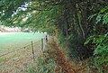
 Monarch's Way looking back at the outskirts of Wolverhampton
 -
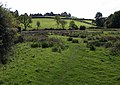 Meadows on the West Deane Way
 -
 Church of All Saints, West Camel, viewed from the Leland Trail


