A | B | C | D | E | F | G | H | CH | I | J | K | L | M | N | O | P | Q | R | S | T | U | V | W | X | Y | Z | 0 | 1 | 2 | 3 | 4 | 5 | 6 | 7 | 8 | 9
Mérida
Estado Mérida (Spanish) | |
|---|---|
 | |
|
| |
| Anthem: Himno del Estado Mérida | |
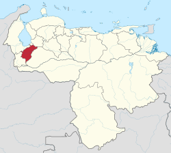
 Location within Venezuela | |
| Coordinates: 8°29′N 71°11′W / 8.48°N 71.19°W | |
| Country | Venezuela |
| Capital | Mérida |
| Government | |
| • Body | Legislative Council |
| • Governor | Ramón Guevara (2017–present) (AD) |
| • Assembly delegation | 6 |
| Area | |
| • Total | 11,300 km2 (4,400 sq mi) |
| • Rank | 15th |
| 1.23% of Venezuela | |
| Population (2011 census) | |
| • Total | 828,592 |
| • Rank | 14th |
| • Density | 73/km2 (190/sq mi) |
| 3,1% of Venezuela | |
| Time zone | UTC−4 (VET) |
| ISO 3166 code | VE-L |
| Emblematic tree | Bucare ceibo (Erythrina poeppigiana) |
| HDI (2019) | 0.700[1] high · 12th of 24 |
| Website | www |

The State of Mérida[2] commonly known simply as Mérida[3][4] (Spanish: Estado Bolivariano de Mérida, IPA: [esˈtaðo ðe ˈmeɾiða]) is one of the 23 states of Venezuela.[5] The state capital is Mérida, in the Libertador Municipality.
Located in the Western Andean Region, Mérida State covers a total surface area of 11,300 square kilometres (4,363 sq mi), making it the fifteenth-largest in Venezuela. In 2011, had a census population of 828,592, the fourteenth most populous.
History
Pre-Colonial

According to recent studies in archaeology, history and anthropology, The Andean region seems to have been inhabited since very remote times (perhaps several thousand years) by unknown groups that have left very few traces.
Then, around our era, another ethnic group of great cultural importance arrives in the region, perhaps of Chibcha origin, since they share with these their mythology, funeral and settlement patterns, housing construction, agricultural techniques, etc. When the Spanish arrive in the Andean Cordillera it will be with this second group you will come in contact with. It is assumed that the majority of today's farmers are descendants of this Chibcha trunk group.
Another later and significant influence for the Andean pre-Hispanic culture are the Arawak groups, belonging to the most important ethnic groups of South America and the Caribbean, which migrated to the Venezuelan Andes during the 9th century AD. Finally, shortly before the arrival of the Spanish, we have a late penetration of Caribbean groups into the Andean region.
From the data of the chroniclers and the archaeological testimonies, today we know that the indigenous agricultural techniques like the irrigation systems (called acequias by the Spaniards) and the cultivation in terraces or andenes (used in all the South American Andes to take advantage of the slopes of the mountains) show for the time of the contact the existence of an economic infrastructure that supposes the presence of a numerous native population in the Andean Mountain range, as well as the existence of a hierarchical political organization and a network of communications in all the zone.

The Spaniards will use this indigenous population base for the development of the society they intended to establish in America. An important area of encomiendas and doctrinal towns. Thanks to this, the current toponymy of the Venezuelan Andes has preserved the names of the many indigenous groups that inhabited this region: Timoto-Cuica, Chama, Mocotíes, Mucuchíes, Tabayes, Mucutuy, Aricagua, etc.
Spanish colonization
In 1558 Juan Rodríguez Suárez founded the city of Mérida, in the name of the Corregimiento de Tunja, in honor of his native city of Mérida in Spain. In December 1607 Merida was separated from the Corregimiento de Tunja and united with the government of La Grita forming the corregimiento de Merida y La Grita. On November 3, 1622 it became the governorship of Merida with Juan Pacheco Maldonado as governor.

In 1676 Maracaibo (separated from the province of Venezuela) and Mérida-La Grita are united in a governorship called Province of Mérida del Espíritu Santo de Maracaibo (capital in Mérida) under the Audiencia of Bogota and then known as "province of Maracaibo" since 1678 that city becomes the capital of the governorship.
By 1677 the Pirate Michel de Grandmont sacked Trujillo, this attack led Governor Jorge de Madureira to change the capital of the province to the city of Maracaibo in 1678, to organize a more effective defense of the territory.
The territory of the province of Merida depended on the Viceroyalty of New Granada until 1777, when the Captaincy General of Venezuela was created.
18th century

In 1811 the province of Merida decided to rebel against Spain and join the process of Venezuelan Independence, along with seven other provinces to form the First Republic of Venezuela. The region would be represented by a star on the Venezuelan flag ever since.
In 1812 an earthquake devastates the city of Merida, and soon after the province is reconquered by the royalists.

The following year during the Admirable Campaign, Simón Bolívar liberates Mérida from the Realists, entering through La Grita (then the province of Mérida) in May 1813. On his journey he passes through Bailadores, Merida and Timotes liberating the province of Merida. With the victory of the Admirable Campaign, Merida is incorporated to the Second Republic of Venezuela.

In 1814 With the loss of the Second Republic, Merida is again temporarily incorporated into the Captaincy General of Venezuela. Three years later, the popular independence movement known as La Patriecita, will be suffocated by the Spanish royalists in 1818.
By 1820 the crossing of the Andes by Bolivar's army, frees Merida again. With the victory of Boyacá on August 7, only the provinces of Maracaibo and Coro remained realistic and Merida was incorporated into the Third Republic of Venezuela.
In 1821 Merida was incorporated into Gran Colombia as part of the Department of Zulia, but in 1830 when Venezuela separated from Gran Colombia, the Department of Zulia was renamed the Province of Maracaibo. The provinces of Merida and Coro were immediately separated, leaving the province composed only of the sections Zulia and Trujillo.
In 1835 the division of the province was established in: Canton Mérida, Canton Mucuchíes, Canton Ejido, Canton Bailadores, Canton La Grita, Canton San Cristóbal and Canton San Antonio del Táchira and in 1842 the governor of the province Gabriel Picón inaugurates the first monument to Bolívar in the world known as La Columna in Milla Park.
Around 1856 the cantons of La Grita, San Crsitóbal and San Antonio del Táchira separate to form the Province of Táchira.
On November 23, 1863, the State of Merida was created with the territory of Merida, Ejido, Bailadores, Mucuchies and Timotes. In 1868 it was incorporated to the State of Zulia, together with Táchira, but it was separated in 1869.
In 1874 it was renamed Guzmán State. In 1881, it became part of the Great State of the Andes together with Táchira and Trujillo. This state was dissolved in 1899 and was limited to the territory it had as an independent state.
20th century
Since 1909 it has been a state of Merida. At the beginning of the century in 1912, after the closure of the Universidad Central de Venezuela by the government of Juan Vicente Gómez, the city of Mérida was left as the only one in the country with access to higher education, a situation that would last until 1922 when the UCV was reopened.
Geography
The state of Merida is located in the west of Venezuela, in the so-called Andean region, forming part of the Andes mountain range of the South American continent; of the three states (Merida, Tachira and Trujillo) that are located in this region. The territory of the state is located in the highest part of Venezuela, therefore, makes Merida the highest state of Venezuela, with altitudes above 4,000 m.a.s.l., reaching its highest point in Pico Bolivar at about 4,970 m.a.s.l.

Mérida is one of the states with the greatest geographical diversity, presenting different landscapes throughout its territory, with high areas above 4,000 m.a.s.l., medium areas with elevations around 900 and 1,600 m.a.s.l. and areas closer to sea level such as the so-called Southern Zone of the Lake below 200 m.a.s.l.
Climate

The climate is temperate but in the relatively small area of Mérida state, there are usually several dramatic climatic changes that occur daily. The climate in Mérida city has an average high temperatures between 24 °C and 25 °C, and low temperatures between 14 °C and 16 °C. At higher peaks on the Sierra Nevada de Mérida, temperatures tend to be under 0 °C. El Vigía sees temperatures around 28 °C. It rains almost every late afternoon in January–February. These are the coldest months. In August and September it often rains at night.
Mérida has temperatures characteristic of each subregion, which can reach 32 °C in the Southern Zone of the Lake, less warm temperatures in the metropolitan area with values around 25 °C, warmer values between 17° and 22° towards the areas of the Mocotí Valley and the Northern Townships, and temperatures below 12 °C in the Southern Townships and the Paramo Townships, even reaching values below 0 °C in the latter.[6]
Vegetation

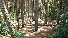
The vegetation is exuberant and there are many lakes and rivers, a great number of which are well stocked with trout, one of the delicacies of Mérida. The most important river in the state is the "Chama" because a large part of the water resources of Venezuela originates in the Mérida mountains. The state tree is the "Bucare" and the state flower is the "Frailejón", The "Coloradito" contains the tree that is found at the highest altitude in the world. In this mountains habitat the "Oso Frontino" bear and the Condor flies through the skies of the páramos and in the lagoons there are many trout.
Hydrography
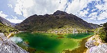
The hydrography of the State of Merida is very varied, because throughout its geography we can find rivers, streams, creeks, natural lakes and glaciers, Merida even has jurisdiction over a small portion of Lake Maracaibo, where we located the beaches Palmarito in the municipality of Tulio Febres Cordero in the south of the lake.

Main rivers
The rivers of the State of Merida are mountain rivers, with abundant flow and steep slopes and form a few deep valleys, longitudinally embedded in the relief. They are located between the Andean alignments of the Sierra de Merida. The main ones are the Motatán in its upper basin and the Chama with its tributaries the Mocotíes and the Mucujún, which belong to the Maracaibo Lake basin, while the Santo Domingo, Caparo and Mucuchachí belong to the Orinoco basin through the Apure River.
Main lagoons

- La Rosa Lagoon
- Lágrima de la India Lagoon
- Los Anteojos Lagoon
- Mucubají Lagoon
- Black Lagoon (Laguna Negra)
- Pico del Toro Lagoon
- Green Lagoon (Laguna Verde)
- El Suero Lagoon
- Urao Lagoon
- Del Humo Lagoon
- El Bizcocho Lagoon
- La Cura Lagoon
- La Barrosa or del Medio Lagoon
- Mina e'hierro lagoons
- Los Chorros Lagoon
- La Carbonera Lagoon
- La Escopeta Lagoon
- Brava Lagoon
- Los Lirios Lagoon
- White Lagoon (Laguna Blanca)
- Santo Cristo Lagoon

Politics and government
The State is autonomous and equal in political terms to the rest of the Federation. It organizes its administration and public powers through the Constitution of the State of Merida, sanctioned by the Legislative Council on November 7, 1995 and promulgated by the State Governor on November 16 of the same year.
Like the other 23 federal entities of Venezuela, the State maintains its own police force, which is supported and complemented by the National Police and the Venezuelan National Guard.
Executive power
It is composed of the Governor of the State of Merida and a group of State Secretaries of his confidence who are freely appointed and removed officials and assist him in the management of the state government. The Governor is elected by the people through direct and secret vote for a period of four years and with the possibility of re-election for other periods, being in charge of the state administration.
Until 1989 the governors were appointed directly from the National Executive, it is only since then that they are directly elected in open elections.
The current governor is Ramón Guevara of the Acción Democrática party elected in the 2017 Regional Elections of Venezuela with 50.82% of the votes.
Zdroj:https://en.wikipedia.org?pojem=Mérida_(state)Text je dostupný za podmienok Creative Commons Attribution/Share-Alike License 3.0 Unported; prípadne za ďalších podmienok. Podrobnejšie informácie nájdete na stránke Podmienky použitia.
Antropológia
Aplikované vedy
Bibliometria
Dejiny vedy
Encyklopédie
Filozofia vedy
Forenzné vedy
Humanitné vedy
Knižničná veda
Kryogenika
Kryptológia
Kulturológia
Literárna veda
Medzidisciplinárne oblasti
Metódy kvantitatívnej analýzy
Metavedy
Metodika
Text je dostupný za podmienok Creative
Commons Attribution/Share-Alike License 3.0 Unported; prípadne za ďalších
podmienok.
Podrobnejšie informácie nájdete na stránke Podmienky
použitia.
www.astronomia.sk | www.biologia.sk | www.botanika.sk | www.dejiny.sk | www.economy.sk | www.elektrotechnika.sk | www.estetika.sk | www.farmakologia.sk | www.filozofia.sk | Fyzika | www.futurologia.sk | www.genetika.sk | www.chemia.sk | www.lingvistika.sk | www.politologia.sk | www.psychologia.sk | www.sexuologia.sk | www.sociologia.sk | www.veda.sk I www.zoologia.sk


