A | B | C | D | E | F | G | H | CH | I | J | K | L | M | N | O | P | Q | R | S | T | U | V | W | X | Y | Z | 0 | 1 | 2 | 3 | 4 | 5 | 6 | 7 | 8 | 9
This article possibly contains original research. (July 2021) |
Makati | |
|---|---|
|
| |
| Etymology: San Pedro Macati | |
| Nickname: Financial Capital of the Philippines | |
| Motto(s): Makati, Mahalin Natin, Atin Ito. ("Makati, let us love it, it is ours.") | |

| |
Location within the Philippines | |
| Coordinates: 14°33′24″N 121°01′17″E / 14.5567°N 121.0214°E | |
| Country | Philippines |
| Region | National Capital Region |
| Province | none |
| District | 1st and 2nd district |
| Founded | June 1, 1670 |
| Renamed | February 28, 1914 (as Makati) |
| Cityhood | February 4, 1995 |
| Recent territorial change | November 9, 2023 |
| Barangays | 23 (since 2023), 33 (until 2023) |
| Government | |
| • Type | Sangguniang Panlungsod |
| • Mayor | Abigail Binay (MKTZNU/NPC) |
| • Vice Mayor | Monique Lagdameo (MKTZNU) |
| • Representatives |
|
| • City Council | Members |
| • Electorate | 458,362 voters (2022) |
| Area | |
| • Total | 21.57 km2 (8.33 sq mi) |
| Elevation | 32 m (105 ft) |
| Highest elevation | 465 m (1,526 ft) |
| Lowest elevation | 0 m (0 ft) |
| Population (2020 census)[3] | |
| • Total | 629,616 (including Embo) |
| • Households | 186,381 (including Embo) |
| Demonym(s) | Makiteño; Makatizen |
| Economy | |
| • Income class | 1st city income class |
| • Poverty incidence | 0.80 |
| • HDI | |
| • Revenue | ₱22,387,841,645.00 (2020) |
| • Assets | ₱ 236,729 million (2020) |
| • Expenditure | ₱ 19,273 million (2020) |
| • Liabilities | ₱ 16,415 million (2020) |
| Service provider | |
| • Electricity | Manila Electric Company (Meralco) |
| Time zone | UTC+8 (PST) |
| ZIP code | 1200–1213, 1219–1235 |
| PSGC | |
| IDD : area code | +63 (0)02 |
| Native languages | Tagalog |
| Major religions | Roman Catholic Church, Eastern Orthodoxy, Christianity |
| Feast date | December 12 |
| Catholic diocese | Roman Catholic Archdiocese of Manila |
| Patron saint | Nuestra Señora de la Rosa |
| Website | www |
Makati (/məˈkɑːti/ mə-KAH-tee; Tagalog pronunciation: [maˈkati]), officially the City of Makati (Filipino: Lungsod ng Makati), is a highly urbanized city in the National Capital Region of the Philippines, known for being one of the leading financial centers in the country. As of 2013, the city has the highest concentration of multinational and local corporations in the Philippines.[5] Major banks, corporations, department stores as well as foreign embassies are based in Makati. Makati is also known for being a major cultural and entertainment hub in Metro Manila.[6] According to the 2020 census, it had a population of 629,616 people,[3] making it as the 47th most populous city in the country and ranked as the 43rd most densely populated city in the world with 19,336 inhabitants per square kilometer or 50,080 inhabitants per square mile. In 2023, the 10 Embo barangays were removed from Makati's jurisdiction as a result of the Makati–Taguig boundary dispute ruling, resulting in a reduction of the city's population to about 292,743. The daytime population of the city is estimated to be more than three million during a typical working day because of the large number of people who go to the city to work, shop, and do business.[7][8]
Etymology
The name of Makati originates from the Tagalog word kati, meaning " low tide" or " ebb tide", attributing to the tidal movements of the adjacent Pasig River. Alternatively, the word may also mean "itchy", attributed to the lipang kalabaw plant (Dendrocnide meyeniana) that once grew in the area.[9]
Previously, it was named San Pedro Macati, a name stylized in Spanish.[10] The first part of the name is derived from Spanish for Saint Peter, the then-town's patron saint.[11][12]
History
This article needs additional citations for verification. (December 2020) |

Spanish colonial era
Parts of the city were once subject to the pre-Hispanic Kingdom of Namayan, whose capital is now in the Santa Ana district of Manila. While under the jurisdiction of the Franciscan friars during the 17th century, it was established as a town on June 1, 1670 under the name San Pedro Macati out of the then-town of Santa Ana de Sapa.[13][14][15] The nearby Nuestra Señora de Gracia Church, changed into the "Our Lady of Guadalupe" church, welcomed an image of the Virgin Mary and devotees from Mexico, and one person from a family in Makati, the Montes De Oca family,[16] which produced Isidoro Montes de Oca who became pivotal in the Mexican war of Independence against Spain. This parish had a large spiritual jurisdiction in the province of Tondo (later known as Manila), extending up to the present-day Muntinlupa.
In 1851, Don José Bonifacio Roxas (an ancestor of the Zóbel de Ayala family) purchased the Jesuit estate of "Hacienda San Pedro de Macati" for 52,800 pesos.[17] Since then, the development of Makati has remained linked with the Zóbel de Ayala family and their company, Ayala Corporation.[18] In 1890, San Pedro de Macati was proclaimed as a public town of Manila province.
American occupation

In 1901, San Pedro Macati was incorporated into the newly established province of Rizal.[20][21] On February 28, 1914, the name of the town was shortened to its present name of Makati, under Philippine Legislature Act No. 2390.[10][13][22]
Japanese occupation

On January 1, 1942, Makati was one of the municipalities of Rizal merged alongside Manila and Quezon City to form the City of Greater Manila as an emergency measure by President Manuel L. Quezon.[23] It regained its pre-war status as a municipality of Rizal when the City of Greater Manila was dissolved by President Sergio Osmeña effective August 1, 1945.[24]
Postwar Era
After the destruction that the Second World War brought upon Manila, and the subsequent closure of Nielson Field, the town grew rapidly, and real estate values boomed. The first of the planned communities (in what are now the barangays Forbes Park, Urdaneta, San Lorenzo, and Bel-Air) were established in the 1950s with the efforts of its landowner, Ayala y Compañía. At the same time, Fort McKinley, then renamed Fort Bonifacio, and the then Philippine Army headquarters, became the starting point for the building up of seven more communities by military families who worked in the base area. New office buildings were built on what is now the Makati Central Business District (CBD). Since the late 1960s, Makati has transformed into the financial and commercial capital of the country.[25] In December 1972, two barangays of Makati were established at the Inner Fort Bonifacio area: Post Proper Northside and Post Proper Southside.[26][27]
On November 7, 1975, Makati was separated from Rizal province to become part of the National Capital Region as a component municipality.[28]
The Martial Law era and after

The beginning months of the 1970s marked a period of turmoil and change in the Philippines, particularly for the areas near the capital.[29] A sudden glut of debt driven public works projects in the late 1960s[30][31] led the Philippine economy to a sudden downward turn known as the 1969 Philippine balance of payments crisis, which in turn led to a period of economic difficulty and social unrest.[32][33] : "43" [34][35] With only a year left in his last constitutionally allowed term as president Ferdinand Marcos placed the Philippines under Martial Law in September 1972 and thus retained the position for fourteen more years.[36] This period in Philippine history is remembered for the Marcos administration's record of human rights abuses,[37][38] particularly targeting political opponents, student activists, journalists, religious workers, farmers, and others who fought against the Marcos dictatorship.[39]
Makati was the setting of what is believed to be the single biggest case of involuntary disappearance during martial law[40][41][42] – the case of the "Southern Tagalog 10" – ten activists from the nearby Southern Tagalog region, mostly in their twenties,[43] who were abducted in late July 1977 at the Makati Medical Center.[44]
Following the assassination of opposition senator Benigno Aquino Jr. on August 21, 1983, Makati became a nexus for protests against the dictatorship of President Ferdinand Marcos. Known as the Confetti Revolution, the demonstrations held in the central business district were led partly by employees of major corporations based in the area, culminating in the 1986 People Power Revolution that toppled Marcos' 20-year authoritarian regime. His political rival and successor, Corazon Aquino–the wife of the deceased senator Aquino–became the eleventh and first female president of the Philippines.
In January 1986, Fort Bonifacio and the Embo barangays of Cembo, South Cembo, West Rembo, East Rembo, Comembo, Pembo and Pitogo were transferred to the control of Makati.[45]
After Mayor Nemesio Yabut succumbed to an illness on February 25, 1986, coinciding with the last day of the People Power Revolution,[46] Aquino appointed Jejomar Binay as acting mayor of Makati two days later; he was subsequently elected as mayor in 1988.[47]
During the 1989 Philippine coup attempt, the Makati central business district was occupied by Reform the Armed Forces Movement forces seeking to overthrow President Corazon Aquino. The resulting standoff lasted from December 2 to December 9 and contributed to massive financial losses incurred due to the paralysis in the economic hub.[48]
Cityhood
On January 2, 1995, President Fidel V. Ramos signed Republic Act No. 7854,[49] making Makati the seventh city in Metro Manila. The law was approved by a plebiscite one month later, on February 2, 1995, by majority of voters.
Contemporary
This section needs expansion with: economic and governance context for when and why events happened. You can help by adding to it. (May 2024) |

On May 17, 2000, at 5:02 p.m. PHT, the Glorietta mall located inside the Ayala Center was bombed, injuring 13 persons. According to local authorities, the homemade bomb originated from the restroom of a restaurant and affected an adjacent video arcade. The bombing was said to be the precursor of the May 21, 2000 SM Megamall bombing and the Rizal Day bombings.[50]
On October 19, 2007, an explosion in Glorietta 2 left eleven people dead and injured more than a hundred. Initially, authorities said that it was caused by a liquefied petroleum gas explosion at a restaurant, but later began investigating the possibility that the explosion may have been a C-4 bomb.[51][52]
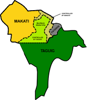
In April 2022, Makati lost in the decades long the territorial dispute with Taguig, which was ruled with finality a year later in April 2023. The city ceded its territorial and political jurisdiction of the ten Embo barangays to Taguig, thus losing an estimated 300,000 people from its population.[53][54][55] However, disputes regarding public facilities like schools and health centers, persists.
Because of Taguig's territorial takeover, Makati's 2nd district, which has three barangays remaining in this city, is put into limbo as it does not meet the constitutional requirement of 250,000 people and may be reduced back to a single congressional district.[56] But pending legislation, the status quo of its existence is expected to prevail.
Geography

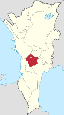
Makati is located within the circle of 14′40″ °N and 121′3″ °E right at the center of Metro Manila. The city is bounded on the north by the Pasig River, facing Mandaluyong, on the east by Taguig, on the southwest by Pasay, and on the northwest by the city of Manila. Makati has a total land area of 21.57 square kilometers (8.33 sq mi). Its territory also surrounds the Manila South Cemetery, an exclave of San Andres district of Manila.[57]
Barangays
Since November 2023, Makati is divided into 23 barangays (the smallest local government units) which handle governance in a much smaller area. These barangays are grouped into two congressional districts where each district is represented by a congressman in the country's House of Representatives. The 1st Congressional District is composed of the barangays straddling EDSA, the barangays to the north and west of them, while excluding Guadalupe Viejo, while the 2nd Congressional District is to the south and east of the 1st District, including the aforementioned barangay. The districts elect the sixteen members of the city council, eight from each of the two councilor districts that are coextensive with the congressional districts.
Cembo, South Cembo, West Rembo, East Rembo, Comembo, Pembo, Pitogo, Post Proper Northside, Post Proper Southside, and Rizal, collectively known as the Embo barangays, were part of Makati until 2023, when these were transferred to Taguig by virtue of the Supreme Court's ruling that year to finally side with Taguig regarding the cities' territorial dispute.[53][54][55][56]

| Barangay | Area (km2) | Population (2010)[58] | Population (2015)[59] | Population (2020)[3] |
|---|---|---|---|---|
| Bangkal | 0.74 | 23,378 | 21,650 | 17,576 |
| Bel-Air | 1.71 | 18,280 | 23,685 | 36,007 |
| Carmona | 0.34 | 3,096 | 3,109 | 2,745 |
| Dasmariñas | 1.90 | 5,654 | 5,589 | 4,160 |
| Forbes Park | 2.53 | 2,533 | 2,335 | 3,715 |
| Guadalupe Nuevo | 0.57 | 18,271 | 18,341 | 20,533 |
| Guadalupe Viejo | 0.62 | 16,411 | 13,415 | 12,900 |
| Kasilawan | 0.09 | 5,291 | 5,881 | 4,827 |
| La Paz | 0.32 | 7,931 | 7,356 | 6,346 |
| Magallanes | 1.20 | 5,576 | 5,672 | 5,267 |
| Olympia | 1.20 | 21,270 | 20,251 | 18,654 |
| Palanan | 0.65 | 17,283 | 14,110 | 11,623 |
| Pinagkaisahan | 0.16 | 5,804 | 5,468 | 4,710 |
| Pio del Pilar | 1.20 | 27,035 | 30,732 | 50,722 |
| Poblacion | 0.46 | 17,120 | 25,393 | 16,706 |
| San Antonio | 0.89 | 11,443 | 16,840 | 17,494 |
| San Isidro | 0.50 | 7,589 | 8,045 | 6,098 |
| San Lorenzo | 2.09 | 10,006 | 12,995 | 14,054 |
| Singkamas | 0.13 | 7,426 | 7,370 | 7,218 |
| Sta. Cruz | 0.47 | 7,440 | 7,207 | 6,333 |
| Tejeros | 0.29 | 13,868 | 13,696 | 15,122 |
| Urdaneta | 0.74 | 3,717 | 4,429 | 4,563 |
| Valenzuela | 0.24 | 7,261 | 6,310 | 5,370 |
Climate
Under the Köppen climate classification system, the city features a tropical monsoon climate. Together with the rest of the Philippines, Makati lies entirely within the tropics. Its proximity to the equator means that the temperature range is very small, rarely going lower than 20 °C (68 °F) or going higher than 38 °C (100 °F). However, humidity levels are usually very high which makes it feel much warmer. It has a distinct, albeit relatively short dry season from January through May, and a relatively lengthy wet season from June through December.


