A | B | C | D | E | F | G | H | CH | I | J | K | L | M | N | O | P | Q | R | S | T | U | V | W | X | Y | Z | 0 | 1 | 2 | 3 | 4 | 5 | 6 | 7 | 8 | 9
Nelson
Whakatū (Māori) | |
|---|---|
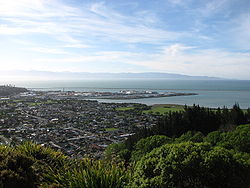
 View of Nelson from the "Centre of New Zealand" in November 2006 | |
|
| |
| Nickname(s): Top of the South, Sunny Nelson | |
| Motto(s): Latin: Palmam qui meruit ferat (Let him, who has earned it, bear the palm) | |
 Nelson within the South Island, New Zealand | |
| Coordinates: 41°16′15″S 173°17′2″E / 41.27083°S 173.28389°E | |
| Country | New Zealand |
| Unitary authority | Nelson City |
| Settled by Europeans | 1841 |
| Founded by | Arthur Wakefield |
| Named for | Horatio Nelson |
| Electorates | Nelson Te Tai Tonga |
| Suburbs | |
| Government | |
| • Body | Nelson City Council |
| • Mayor | Nick Smith |
| • Deputy mayor | Rohan O'Neill-Stevens |
| • MPs | Rachel Boyack (Labour) Tākuta Ferris (Te Pāti Māori) |
| Area | |
| • Territorial | 422.19 km2 (163.01 sq mi) |
| • Urban | 54.69 km2 (21.12 sq mi) |
| Population (June 2023)[1] | |
| • Territorial | 55,600 |
| • Density | 130/km2 (340/sq mi) |
| • Urban | 51,900 |
| • Urban density | 950/km2 (2,500/sq mi) |
| Time zone | UTC+12 (NZST) |
| • Summer (DST) | UTC+13 (NZDT) |
| Postcode | 7010, 7011, 7020 |
| Area code | 03 |
| HDI (2021) | 0.927[2] very high · 7th |

Nelson (Māori: Whakatū) is a New Zealand city and unitary authority on the eastern shores of Tasman Bay at the top of the South Island. It is the oldest city in the South Island and the second-oldest settled city in New Zealand; it was established in 1841 and became a city by royal charter in 1858.[3]
Nelson City is bordered to the west and south-west by the Tasman District and to the north-east, east and south-east by the Marlborough District. The Nelson urban area has a population of 51,900,[1] making it New Zealand's 15th most populous urban area.
Nelson is well known for its thriving local arts and crafts scene; each year, the city hosts events popular with locals and tourists alike, such as the Nelson Arts Festival.[4]
Etymology
Nelson was named in honour of Admiral Horatio Nelson, who defeated both the French and Spanish fleets at the Battle of Trafalgar in 1805. Many roads and public areas around the city are named after people and ships associated with that battle. Inhabitants of the city are referred to as Nelsonians; Trafalgar Street is its main shopping axis.
Nelson's Māori name, Whakatū,[5] means 'construct', 'raise', or 'establish'.[6]
In an article to The Colonist newspaper on 16 July 1867, Francis Stevens described Nelson as "The Naples of the Southern Hemisphere".[7] Today, Nelson has the nicknames of "Sunny Nelson" due to its high sunshine hours per year or the "Top of the South" because of its geographic location.
In New Zealand Sign Language, the name is signed by putting the index and middle fingers together which are raised to the nose until the fingertips touch the nose, then move the hand forward so that the fingers point slightly forward away from oneself.[8]
History

Early settlement
Settlement of Nelson began about 700 years ago by Māori.[9] There is evidence that the earliest settlements in New Zealand were around the Nelson-Marlborough regions. Some of the earliest recorded iwi in the Nelson district are Ngāti Hāwea, Ngāti Wairangi, Waitaha and Kāti Māmoe.[10] Waitaha people developed the land around the Waimea Gardens, are believed to have been the first people to quarry argillite in around Nelson. They also developed much of the Waimea Gardens complex – more than 400 hectares on the Waimea Plains near Nelson.[11] In the early 1600s, Ngāti Tūmatakōkiri displaced other te Tau Ihu Māori, becoming the dominant tribe in the area until the early 1800s.[10] Raids from northern tribes in the 1820s, led by Te Rauparaha and his Ngāti Toa, soon decimated the local population and quickly displaced them.
Today there are eight mutually recognised tribes of the northernwestern region: Ngāti Kuia, Ngāti Apa ki te Rā Tō, Rangitāne, Ngāti Toarangatira, Ngāti Koata, Ngāti Rārua, Ngāti Tama and Te Atiawa o Te Waka-a-Māui.[10]
Historic places
There are three[dubious – discuss] main historic places located in Nelson, New Zealand. They are Broadgreen Historic House, Isel House, and Founders Heritage Park. The Broadgreen Historic House was originally built in 1855 for Mr and Mrs Edmund Buxton, additionally with their six daughters. The house was later sold to a Fred Langbein in 1901, who lived there with his family until 1965. In 1965, the house was bought by the Nelson City Council and is now used operated a museum for the general public.[citation needed]
Isel House is a local historical building located in Nelson. It was home to one of Nelson's first families, the Marsdens. Many of the rooms have been transformed into displays for the public to view. The restoration of Isel House is managed by Isel House Charitable trust under the supervision of Sally Papps, but the house and the park ground surrounding it are owned by the Nelson City Council.[12]
Founders Heritage Park is a local historical visit in Nelson. This interactive park shows visitors the history of Nelson, New Zealand. The park is set up as a village filled with buildings set in a historical time, including well established gardens. Throughout the park, there are stories to be learned about the history of this town.[13]
New Zealand Company
Planning
The New Zealand Company in London planned the settlement of Nelson. They intended to buy from the Māori some 200,000 acres (810 km2) of land, which they planned to divide into one thousand lots and sell to intending settlers. The company earmarked profits to finance the free passage of artisans and labourers, with their families, and for the construction of public works. However, by September 1841 only about one third of the lots had sold. Despite this, the colony pushed ahead, and land was surveyed by Frederick Tuckett.[14]

Three ships, the Arrow, Whitby, and Will Watch, sailed from London commanded by Captain Arthur Wakefield. Arriving in New Zealand, they discovered that the new Governor of the colony, William Hobson, would not give them a free hand to secure vast areas of land from the Māori or indeed to decide where to site the colony. However, after some delay, Hobson allowed the Company to investigate the Tasman Bay area at the north end of the South Island. The Company selected the site now occupied by Nelson City because it had the best harbour in the area. But it had a major drawback: it lacked suitable arable land; Nelson City stands right on the edge of a mountain range while the nearby Waimea Plains amount to only about 60,000 acres (240 km2), less than one third of the area required by the Company plans.
The Company secured land from the Māori, that was not clearly defined, for £800: it included Nelson, Waimea, Motueka, Riwaka and Whakapuaka. This allowed the settlement to begin, but the lack of definition would prove the source of much future conflict. The three colony ships sailed into Nelson Haven during the first week of November 1841. When the four first immigrant ships – Fifeshire, Mary-Ann, Lord Auckland and Lloyds – arrived three months later, they found the town already laid out with streets, some wooden houses, tents and rough sheds. The town was laid out on a grid plan.[15] Within 18 months, the Company had sent out 18 ships with 1052 men, 872 women and 1384 children. However, fewer than ninety of the settlers had the capital to start as landowners.
Cultural and religious immigrants

The early settlement of Nelson province included a proportion of German immigrants, who arrived on the ship Sankt Pauli and formed the nucleus of the villages of Sarau (Upper Moutere) and Neudorf. These were mostly Lutheran Protestants with a small number of Bavarian Catholics.[16]
In 1892, the New Zealand Church Mission Society (NZCMS) was formed in a Nelson church hall.[17]
Churches In Nelson, New Zealand:
Zdroj:https://en.wikipedia.org?pojem=Nelson,_New_Zealand
Text je dostupný za podmienok Creative Commons Attribution/Share-Alike License 3.0 Unported; prípadne za ďalších podmienok. Podrobnejšie informácie nájdete na stránke Podmienky použitia.
Antropológia
Aplikované vedy
Bibliometria
Dejiny vedy
Encyklopédie
Filozofia vedy
Forenzné vedy
Humanitné vedy
Knižničná veda
Kryogenika
Kryptológia
Kulturológia
Literárna veda
Medzidisciplinárne oblasti
Metódy kvantitatívnej analýzy
Metavedy
Metodika
Text je dostupný za podmienok Creative
Commons Attribution/Share-Alike License 3.0 Unported; prípadne za ďalších
podmienok.
Podrobnejšie informácie nájdete na stránke Podmienky
použitia.
www.astronomia.sk | www.biologia.sk | www.botanika.sk | www.dejiny.sk | www.economy.sk | www.elektrotechnika.sk | www.estetika.sk | www.farmakologia.sk | www.filozofia.sk | Fyzika | www.futurologia.sk | www.genetika.sk | www.chemia.sk | www.lingvistika.sk | www.politologia.sk | www.psychologia.sk | www.sexuologia.sk | www.sociologia.sk | www.veda.sk I www.zoologia.sk


