A | B | C | D | E | F | G | H | CH | I | J | K | L | M | N | O | P | Q | R | S | T | U | V | W | X | Y | Z | 0 | 1 | 2 | 3 | 4 | 5 | 6 | 7 | 8 | 9
This article needs additional citations for verification. (April 2013) |
Northern Samar
Hilagang Samar (Filipino) | |
|---|---|
| Province of Northern Samar | |
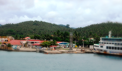
(from top: left to right) USS Essex transits through the San Bernardino Strait, Dalupiri Island, Church of Bobon, Provincial Capitol, San Vicente Islands and Port of Allen. | |
 | |
| Coordinates: 12°20′N 124°40′E / 12.33°N 124.67°E | |
| Country | Philippines |
| Region | Eastern Visayas |
| Founded | June 19, 1965 |
| Capital and largest municipality | Catarman |
| Government | |
| • Type | Sangguniang Panlalawigan |
| • Governor | Edwin C. Ongchuan (PFP) |
| • Vice Governor | Clarence E. Dato (PFP) |
| • Legislature | Northern Samar Provincial Board |
| Area | |
| • Total | 3,692.93 km2 (1,425.85 sq mi) |
| • Rank | 34th out of 81 |
| Highest elevation | 514 m (1,686 ft) |
| Population (2020 census)[2] | |
| • Total | 639,186 |
| • Rank | 48th out of 81 |
| • Density | 170/km2 (450/sq mi) |
| • Rank | 51st out of 81 |
| Divisions | |
| • Independent cities | 0 |
| • Component cities | 0 |
| • Municipalities | |
| • Barangays | 569 |
| • Districts | Legislative districts of Northern Samar |
| Time zone | UTC+8 (PHT) |
| ZIP code | 6400–6423 |
| IDD : area code | +63 (0)55 |
| ISO 3166 code | PH-NSA |
| Spoken languages | |
| Highway routes | |
| Website | northernsamar |
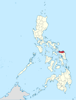
Northern Samar (Waray: Amihanan Samar/Norte san Samar; Tagalog: Hilagang Samar[3]), officially the Province of Northern Samar, is a province in the Philippines located in the Eastern Visayas region. Its capital is Catarman and is located at the northern portion of the island of Samar. Bordering the province to the south are the provinces of Samar and Eastern Samar. To the northwest, across the San Bernardino Strait is Sorsogon; to the east is the Philippine Sea of the Pacific Ocean and to the west is Samar Sea.
History
Spanish colonial era
Historian William Henry Scott wrote that a "Samar datu by the name of Iberein was rowed out to a Spanish vessel anchored in his harbor in 1543 by oarsmen collared in gold; while wearing on his own person earrings and chains." In the local epic called siday entitled Bingi of Lawan as written in the article of Scott, Lawan is a prosperous Lakanate in Samar particularly the northernmost part. Datu Hadi Iberein came from the Lakanate of Lawan [4]
In 1614, the Jesuits established a mission residence in Palapag among the Ibabao populace. These missionaries stayed until the late 17th century when they were expelled from the Philippines in 1768 and were replaced by the Franciscans.
As the San Bernardino Strait was along the route of the Spanish galleons plying between Manila and Acapulco, Mexico, a royal port was established in Palapag where the richly laden Manila Galleons were protected from unfavorable winds and troubled seas.
In the early years of the 16th century, shipbuilders were drafted from Palapag to the Cavite shipyards for the construction of galleons and vessels for the conservation of defense of the island. It was also at this time that these recruits ignited the Sumoroy insurrection, which signaled a general uprising against Spain in the Visayas and Mindanao. The insurrection simultaneously flared northward to Albay and southward to the northern coasts of Mindanao and then Cebu. It took over a year before the Spaniards were able to subdue the rebellion.
American invasion era
Later in 1898, when the Americans landed on the beach of Catarman, they organized a revolutionary army led by General Vicente Lukban who fought the invaders armed with cannons and rifles with only bolos and paltiks. Although defeated, they, however, continued to harass the Americans through guerrilla warfare.
Japanese occupation era
During World War II, the people of Northern Samar organized a platoon of volunteers supported by voluntary contributions. The contingent became a part of the Philippine National Guard in Manila. The province also helped the government by purchasing a considerable amount of bonds floated to finance the National Commission for Independence, then organized by Manuel L. Quezon after a coalition of the Nacionalista and Democrata parties were formed.
Philippine independence
Congressmen Eladio T. Balite (1st Dist. Samar), Fernando R. Veloso (2nd Dist. Samar), and Felipe J. Abrigo (3rd Dist. Samar), authored Republic Act 4221 which was approved by Congress in 1963. The law, ratified in a plebiscite on June 19, 1965, divided Samar into three: Northern Samar, Eastern Samar and (Western) Samar.[5] The first provincial officials of Northern Samar were elected on November 14, 1967, and on January 1, 1968, they officially assumed office.
Geography

Northern Samar covers a total area of 3,692.93 square kilometres (1,425.85 sq mi)[6] occupying the northern section of Samar Island in the Eastern Visayas region. The province is bounded by north by the San Bernardino Strait, on the east by the Pacific Ocean, on the west by the Samar Sea, on the southwest by Samar and on the southeast by Eastern Samar. It ranks thirty-seventh (37th) in size among the 80 provinces of the Philippines and accounts for practically 1.2 percent of the total land area of the country. About 52 percent of the total land area is covered by forest and 42 percent is classified as alienable and disposable.
The province is composed largely of low and extremely rugged hills and small lowland areas. It also has small and discontinuous areas along the coasts and its rivers are usually accompanied by alluvial plains and valleys. The province is endowed with relatively rich and fertile soil that most crops can grow on it.
Topography
Northern Samar has a very rugged terrain with restricted pocket plains and valleys. River valleys are low-lying and are often interrupted by hills, while the remaining portion is rolling, hilly, and mountainous. The interior of the mainland consists of highly dissected hills and mountain peaks. Low-lying hills are found between the coastal plains of Palapag, the river valley of Gamay, and Catubig Valley. There are lagoons and lakes (Cinco Forest), and falls near Catubig named Pinipisikan (citation tourism) too.
Climate
Northern Samar falls under the intermediate type climate, which has no distinct dry and wet seasons. The rainiest months are October to January, while the driest is the month of May.
Administrative divisions

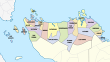
Northern Samar is divided into three major geographical areas, namely: Balicuatro area, Central area, and Pacific area including Catubig Valley – the province's rice granary. It comprises 24 towns or municipalities with 569 registered barangays. The province is divided into two legislative districts, the first district, covering the Balicuatro and most part of the Central Area, and the second district, covering the some part of the Central Area, the Pacific Area and the Catubig Valley.
† Provincial capital


