

A | B | C | D | E | F | G | H | CH | I | J | K | L | M | N | O | P | Q | R | S | T | U | V | W | X | Y | Z | 0 | 1 | 2 | 3 | 4 | 5 | 6 | 7 | 8 | 9
Okazaki
岡崎市 | |
|---|---|
 Flag  Emblem | |
 Interactive map outlining Okazaki | |
 Location of Okazaki in Aichi Prefecture | |
 Okazaki | |
| Coordinates: 34°57′15.6″N 137°10′27.7″E / 34.954333°N 137.174361°E | |
| Country | Japan |
| Region | Chūbu (Tōkai) |
| Prefecture | Aichi |
| First official recorded | 315 AD |
| City Settled | June 1, 1916 |
| Government | |
| • Mayor | Yasuhiro Nakane |
| Area | |
| • Total | 387.20 km2 (149.50 sq mi) |
| Population (October 1, 2019) | |
| • Total | 386,999 |
| • Density | 1,000/km2 (2,600/sq mi) |
| Time zone | UTC+9 (Japan Standard Time) |
| Phone number | 0564-23-6495 |
| Address | 2–9 Jūō-chō, Okazaki-shi, Aichi-ken 444-8601 |
| Climate | Cfa |
| Website | Official website |
| Symbols | |
| Bird | Japanese white wagtail |
| Flower | Wisteria |
| Tree | Japanese black pine |


Okazaki (岡崎市, Okazaki-shi) is a city located in Aichi Prefecture, Japan. As of 1 October 2019[update], the city had an estimated population of 386,999 in 164,087 households,[1] and a population density of 999 persons per km². The total area of the city was 387.20 km2 (149.50 sq mi).
Geography
Okazaki is in the coastal plains of southeastern Aichi Prefecture. The ground rises to undulating hills in the former Nukata area to the northeast. About 60 percent of the city area is forested and remains sparsely populated.[citation needed]
Okazaki is about 250 miles (400 km) from Tokyo, to the southwest.[2]
Climate
The city has a climate characterized by hot and humid summers, and relatively mild winters (Köppen climate classification Cfa). The average annual temperature in Okazaki is 15.5 °C (59.9 °F). The average annual rainfall is 1,507.6 mm (59.35 in) with September as the wettest month. The temperatures are highest on average in August, at around 27.4 °C (81.3 °F), and lowest in January, at around 4.1 °C (39.4 °F).[3]
| Climate data for Okazaki (1991−2020 normals, extremes 1979−present) | |||||||||||||
|---|---|---|---|---|---|---|---|---|---|---|---|---|---|
| Month | Jan | Feb | Mar | Apr | May | Jun | Jul | Aug | Sep | Oct | Nov | Dec | Year |
| Record high °C (°F) | 17.2 (63.0) |
21.6 (70.9) |
24.6 (76.3) |
29.5 (85.1) |
32.8 (91.0) |
36.1 (97.0) |
39.3 (102.7) |
38.8 (101.8) |
37.8 (100.0) |
31.9 (89.4) |
26.1 (79.0) |
23.1 (73.6) |
39.3 (102.7) |
| Mean daily maximum °C (°F) | 9.1 (48.4) |
10.2 (50.4) |
14.1 (57.4) |
19.6 (67.3) |
24.2 (75.6) |
27.1 (80.8) |
31.0 (87.8) |
32.7 (90.9) |
29.0 (84.2) |
23.3 (73.9) |
17.4 (63.3) |
11.6 (52.9) |
20.8 (69.4) |
| Daily mean °C (°F) | 4.1 (39.4) |
5.0 (41.0) |
8.6 (47.5) |
13.8 (56.8) |
18.6 (65.5) |
22.3 (72.1) |
26.2 (79.2) |
27.4 (81.3) |
23.9 (75.0) |
17.9 (64.2) |
11.8 (53.2) |
6.4 (43.5) |
15.5 (59.9) |
| Mean daily minimum °C (°F) | −0.7 (30.7) |
0.0 (32.0) |
3.1 (37.6) |
8.1 (46.6) |
13.3 (55.9) |
18.2 (64.8) |
22.5 (72.5) |
23.3 (73.9) |
19.7 (67.5) |
13.2 (55.8) |
6.5 (43.7) |
1.4 (34.5) |
10.7 (51.3) |
| Record low °C (°F) | −7.6 (18.3) |
−7.6 (18.3) |
−4.7 (23.5) |
−1.9 (28.6) |
3.1 (37.6) |
8.9 (48.0) |
15.1 (59.2) |
14.8 (58.6) |
7.8 (46.0) |
2.3 (36.1) |
−1.7 (28.9) |
−6.5 (20.3) |
−7.6 (18.3) |
| Average precipitation mm (inches) | 53.7 (2.11) |
60.9 (2.40) |
115.8 (4.56) |
123.6 (4.87) |
139.4 (5.49) |
177.1 (6.97) |
184.1 (7.25) |
117.9 (4.64) |
223.5 (8.80) |
177.1 (6.97) |
80.2 (3.16) |
57.2 (2.25) |
1,507.6 (59.35) |
| Average precipitation days (≥ 1.0 mm) | 5.4 | 6.3 | 9.2 | 9.4 | 9.7 | 12.0 | 11.0 | 7.7 | 10.6 | 9.9 | 6.6 | 6.1 | 103.9 |
| Mean monthly sunshine hours | 172.0 | 165.5 | 191.5 | 193.5 | 194.2 | 136.7 | 164.8 | 210.8 | 159.6 | 162.2 | 162.8 | 167.4 | 2,081 |
| Source: Japan Meteorological Agency[4][3] | |||||||||||||
Demographics
Per Japanese census data,[5] the population of Okazaki has grown steadily over the past 60 years. This fast population growth reflects the low unemployment rate, as well as affordable housing close to Nagoya. Of the total population, in November 2019 there were 12,581 are foreign nationals (2.92% of the total, compared with the nationwide average of 1.55%). There are 6,148 foreign males and 6,433 foreign females with a total of 6990 households. Including those registered as stateless, the foreign population comes from 71 nationalities, though more than half are from Brazil. Other significant foreign communities include Koreans, Chinese and Filipinos.
| Year | Pop. | ±% |
|---|---|---|
| 1960 | 186,559 | — |
| 1970 | 219,092 | +17.4% |
| 1980 | 271,243 | +23.8% |
| 1990 | 316,334 | +16.6% |
| 2000 | 345,997 | +9.4% |
| 2010 | 373,472 | +7.9% |
Surrounding municipalities
Cityscape
-
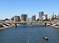 Skyline of Okazaki City and Oto River
 -
-
 Hatchō town
 -
 OkazakiMinami Park
 -
 OkazakiHigashi Park Zoo


History
Origins
The area around present-day Okazaki has been inhabited for many thousands of years. Archaeologists have found remains from the Japanese Paleolithic period. Numerous remains from the Jōmon period, and especially from the Yayoi and Kofun periods, have been found, including many kofun burial mounds.
Sengoku period
During the Sengoku period, the area was controlled by the Matsudaira clan, a branch of which later rose to prominence as the Tokugawa clan, who ruled Japan during the Edo period.
Edo period
During this time, Okazaki Domain, a feudal han was established to rule the immediate area around Okazaki and was entrusted to a fudai daimyō. Several smaller domains were in the present-day city limits, including Fukozu (later Mikawa-Nakajima), Okudono Domain and Nishi-Ohira Domain. The town prospered as a post station on the Tōkaidō connecting Edo with Kyoto.
Meiji period
Following the Meiji Restoration, the modern town of Okazaki was established on October 1, 1889 with the establishment of the modern municipalities system in Nukata District of Aichi Prefecture. On October 1, 1914, Okazaki annexed neighboring Hirohata Town. Okazaki was proclaimed a city on July 1, 1916.
The city suffered damage in both the 1944 Tōnankai earthquake (which killed 9 people) and the 1945 Mikawa earthquake (which killed 29 people). During World War II, the July 19, 1945 Bombing of Okazaki killed over 200 people and destroyed most of the city center. Although Okazaki was the location of an Imperial Japanese Navy airfield, military installations were not damaged in the attack.
Modern Okazaki
In 1955, through a series of mergers and consolidations, the area of Okazaki expanded considerably. The former towns of Iwazu, Fukuoka, and Yahagi, and the villages of Motojuku, Yamanaka, Kawai, Fujikawa, and Ryugai were all merged into Okazaki. The 1959 Isewan Typhoon caused considerable damage, and killed 27 residents. On October 15, 1962, Okazaki annexed the neighboring town of Mutsumi.
Okazaki was proclaimed a core city on April 1, 2003, with increased autonomy from the prefectural government. On January 1, 2006, the town of Nukata (from Nukata District) was merged into Okazaki.
Government
Zdroj:https://en.wikipedia.org?pojem=Okazaki,_AichiText je dostupný za podmienok Creative Commons Attribution/Share-Alike License 3.0 Unported; prípadne za ďalších podmienok. Podrobnejšie informácie nájdete na stránke Podmienky použitia.
Antropológia
Aplikované vedy
Bibliometria
Dejiny vedy
Encyklopédie
Filozofia vedy
Forenzné vedy
Humanitné vedy
Knižničná veda
Kryogenika
Kryptológia
Kulturológia
Literárna veda
Medzidisciplinárne oblasti
Metódy kvantitatívnej analýzy
Metavedy
Metodika
Text je dostupný za podmienok Creative
Commons Attribution/Share-Alike License 3.0 Unported; prípadne za ďalších
podmienok.
Podrobnejšie informácie nájdete na stránke Podmienky
použitia.
www.astronomia.sk | www.biologia.sk | www.botanika.sk | www.dejiny.sk | www.economy.sk | www.elektrotechnika.sk | www.estetika.sk | www.farmakologia.sk | www.filozofia.sk | Fyzika | www.futurologia.sk | www.genetika.sk | www.chemia.sk | www.lingvistika.sk | www.politologia.sk | www.psychologia.sk | www.sexuologia.sk | www.sociologia.sk | www.veda.sk I www.zoologia.sk