

A | B | C | D | E | F | G | H | CH | I | J | K | L | M | N | O | P | Q | R | S | T | U | V | W | X | Y | Z | 0 | 1 | 2 | 3 | 4 | 5 | 6 | 7 | 8 | 9
Rochester | |
|---|---|
 Seal  Logo | |
| Nickname(s): "The Flour City", "The Flower City", "The World's Image Center" | |
 Interactive map outlining Rochester | |
 Rochester  Rochester | |
| Coordinates: 43°09′56″N 77°36′58″W / 43.16556°N 77.61611°W | |
| Country | United States |
| State | New York |
| Region | Western New York; Genesee Valley; Finger Lakes Region |
| Metro | Rochester metropolitan area |
| County | Monroe |
| Founded | 1788 |
| Incorporated (village) | March 21, 1817 (as Rochesterville) |
| Incorporated (city) | April 28, 1834 |
| Named for | Nathaniel Rochester |
| Government | |
| • Type | Mayor–council |
| • Mayor | Malik Evans (D) |
| • City council | List |
| Area | |
| • City | 37.17 sq mi (96.27 km2) |
| • Land | 35.76 sq mi (92.62 km2) |
| • Water | 1.41 sq mi (3.65 km2) 3.6% |
| Highest elevation | 702 ft (214 m) |
| Lowest elevation | 230 ft (70 m) |
| Population (2020) | |
| • City | 211,328 |
| • Rank | US: 108th NY: 4th |
| • Density | 5,909.45/sq mi (2,281.62/km2) |
| • Urban | 704,327 (US: 62nd) |
| • Urban density | 2,413.5/sq mi (931.9/km2) |
| • Metro | 1,067,486 (US: 52nd) |
| Demonym | Rochesterian |
| Time zone | UTC−05:00 (EST) |
| • Summer (DST) | UTC−04:00 (EDT) |
| ZIP codes | 146xx (14604=downtown) |
| Area code | 585 |
| FIPS code | 36-63000 |
| GNIS feature ID | 979426[2] |
| Website | cityofrochester.gov |


Rochester (/ˈrɒtʃɛstər, -ɪs-/) is a city in the U.S. state of New York and the county seat of Monroe County. It is the fourth-most populous city and 10th most-populated municipality[3] in New York, with a population of 211,328 at the 2020 census.[4] The city forms the core of the larger Rochester metropolitan area in Western New York, with a population of just over 1 million residents. Throughout its history, Rochester has acquired several nicknames based on local industries; it has been known as "the Flour City" and "the Flower City" for its dual role in flour production and floriculture,[5] and as the "Imaging Capital of the World" for its association with film, optics, and photography.[6]
The city was one of the United States' first boomtowns, initially due to the fertile Genesee River valley which gave rise to numerous flour mills, and then as a manufacturing center, which spurred further rapid population growth.[7] Rochester has also played a key part in US history as a hub for social and political movements, especially abolitionism,[8] and the women's rights movement.[9]
Rochester is the birthplace and/or home of many notable companies including Eastman Kodak, Xerox, Bausch & Lomb, Wegmans, Gannett, Paychex, and Western Union, and the region became a global center for science, technology, and research and development. This has been aided by the presence of several internationally renowned universities, notably the University of Rochester and Rochester Institute of Technology, and their research programs; these schools, along with many other smaller colleges, have played an increasingly large role in its economy.[10] The city experienced significant population decline due to deindustrialization in the late 20th century, although less severely than its Rust Belt peers. The Rochester metropolitan area is the third-largest regional economy in New York, after New York City and Buffalo-Niagara Falls.[11][12]
Rochester is also known for its culture; in particular, the Eastman School of Music, one of the most prestigious conservatories in the world, and the Rochester International Jazz Festival anchor a vibrant music industry.[13] It is the site of several museums such as The Strong National Museum of Play and the George Eastman Museum, which houses the oldest photography collection in the world.[14]
History
Nineteenth century
The Seneca tribe of the Iroquois Confederacy lived around Rochester prior to the American Revolution, and used the area as a hunting ground.[15] Allied with the British, the Seneca were forced to cede or sell most of their land in New York after the war. The area now occupied by Rochester was ceded in the Phelps and Gorham Purchase of 1788. As a reward for their loyalty to the British crown, the Iroquois were given a large land grant on the Grand River in Canada.[16][17]
Rochester was founded shortly after by a wave of English-Puritan-descended immigrants from New England, who were looking for new agricultural land. They were the dominant cultural group in Rochester for over a century.[18] On November 8, 1803, three men from Hagerstown, Maryland, purchased a 100-acre (40-ha) tract from the Pulteney Estate along the Genesee River: Major Charles Carroll, Colonel William Fitzhugh Jr, and Colonel Nathaniel Rochester, the namesake of the city. They chose the site because its three cataracts on the Genesee offered great potential for water power. Beginning in 1811, and with a population of 15, the three founders surveyed the land and laid out streets and tracts.[19] In 1817, the Brown brothers and other landowners joined their lands with the Hundred Acre Tract to form the village of Rochesterville. This name was unpopular, and in 1822 it was shortened to Rochester.[20]
By 1821, Rochesterville became the seat of Monroe County.[21] In 1823, the Erie Canal aqueduct over the Genesee River was completed, connecting the city to the Hudson River to the east.[22] New commerce from the canal turned the village into America's first boomtown.[23] By 1830, Rochester's population had grown to 9,200,[24] and in 1834, it was rechartered as a city.[25] Rochester was first known as "the Young Lion of the West", and then as the "Flour City". By 1838, it was the largest flour-producing city in the United States.[5] A series of religious revivals occurred in the as part of the Second Great Awakening, including a particularly notable revival led by Charles Grandison Finney which inspired local social reform movements.[26]
During the mid-19th century, as the center of the wheat-processing industry moved west with population and agriculture, the city became home to an expanding nursery business, giving rise to the city's second nickname, the Flower City. Nurseries ringed the city, the most famous of which was started in 1840 by immigrants George Ellwanger from Germany and Patrick Barry from Ireland.[27] Shoemaking also became a major local industry as the city began to industrialize.[28]
In 1847, Frederick Douglass founded The North Star, an abolitionist newspaper, in Rochester. A former slave and an antislavery speaker and writer, he gained a circulation of over 4,000 readers in the United States, Europe, and the Caribbean.[29] Douglass lived in Rochester until his home was destroyed in a fire in 1872, and a historical marker was erected at the site on South Avenue.[30] Many other prominent abolitionists operated in the area and operated on the Underground Railroad, such as Thomas James and Austin Steward.[31]
Around the same time, the nearby Finger Lakes region was the birthplace of the women's suffrage movement. A critical suffragettes' convention was held in 1848 in nearby Seneca Falls, and Rochester was the home of Susan B. Anthony along with other notable Suffragettes such as Abigail Bush and Amy Post. The city itself played host to the Rochester Women's Rights Convention of 1848.[32] The Nineteenth Amendment to the United States Constitution, in 1920, which guaranteed the right of women to vote, was known as the Susan B. Anthony Amendment because of her work toward its passage, which she did not live to see.[33] Anthony's home is a National Historic Landmark known as the National Susan B. Anthony Museum and House.[34]
Twentieth century
Rochester saw an expansion of new industries in the late 19th century and early 20th century. Irish immigrant James Cunningham founded the carriagemaker James Cunningham, Son and Company.[35] James Cunningham and Sons later founded the Cunningham Car Company, a pioneer automobile maker.[36] German immigrants John Jacob Bausch and Henry Lomb launched Bausch & Lomb in 1861 and inventor and entrepreneur George Eastman founded Eastman Kodak in 1892. Xerox was founded in Rochester in 1906 as the Haloid Company.[37] In the early 20th century, Rochester became a center of the garment industry, particularly men's fashions. It was the base of Bond Clothing Stores, Fashion Park Clothes, Hickey Freeman, and Stein-Bloch and Co.[28] The Erie Canal was rerouted south of Rochester by 1918 to allow widening as part of the Barge Canal's construction.[38] The short-lived Rochester subway was constructed in the abandoned canal bed and operated from 1927 to 1956.[39]
The dawn of the 20th century in Rochester saw rapid growth, driven by waves of immigrants arriving from Germany, Italy, Poland, and elsewhere.[40] The city also grew in area, annexing suburban neighborhoods from the surrounding towns to arrive at its present borders.[41] The population reached 62,386 in 1870, 162,608 in 1900, and 295,750 in 1920. By 1950, the population had reached a high of 332,488.[42] The surge in new arrivals, along with increased industrialization, resulted in the city becoming a hotbed of labor activism.[43] From the 1920s and continuing into the post-war era Rochester grew into a power center for newly formed industrial unions.[44] It was one of the very few American cities where the labor movement was powerful enough to mount a successful general strike when in 1946 an estimated 50,000 workers across multiple sectors walked off in support of hundreds of city employees who had been fired for attempting to unionize.[45][46]

During World War II, Rochester factories produced a variety of goods for the war effort, including fuel tanker ships, optical equipment, and radio proximity fuses, amounting to US$1,200,000,000 of military orders.[47] Following the war, the city began engaging in urban renewal projects to revitalize downtown, including the construction of Midtown Plaza and freeways like the Inner Loop, and the demolition of the Front Street neighborhood.[48] By the 1970s, the city experienced highway revolts against new projects,[49] and in the 2010s, the city began filling in the Inner Loop to restore older neighborhoods.[50]
In 1950, the Census Bureau reported Rochester's population as 97.6% White and 2.3% Black.[42] Rochester's black population tripled to more than 25,000 during the 1950s. Casually employed by the city's major industries, most African Americans in the city held low-pay and low-skill jobs, and lived in substandard housing. Discontent exploded in the three-day 1964 Rochester race riot, which resulted in five deaths, 350 injuries, nearly a thousand arrests, and 204 stores looted or damaged.[51][52] In the wake of the riot, the Rochester Area Churches, together with black civil rights leaders, invited Saul Alinsky of the Industrial Areas Foundation to help the community organize. With the Reverend Franklin Florence, they established FIGHT (Freedom, Integration, God, Honor, Today), which successfully brought pressure to bear on Eastman Kodak to help open up employment and city governance.[53][54]
With industrial restructuring in the later 20th century, Rochester's manufacturing workforce shrank.[55] Kodak, long the city's largest employer, conducted massive layoffs prior to a 2012 bankruptcy. By 2022, the city's population had declined to 209,352 (although the metropolitan area was considerably larger) with 45.1% recorded as White and 38.4% as Black or African American.[56] Although the total population declined, new arrivals continued to move to the city and change its demographic profile. Thousands of Puerto Ricans moved to the city after World War II,[57] and the city became a major destination for refugees in the 21st century.[58]
Geography

Rochester is located in Upstate New York,[59] on the southern shore of Lake Ontario. The Genesee River bisects the city. According to the United States Census Bureau, the city has a total area of 37.1 square miles (96 km2), of which 35.8 square miles (93 km2) are land and 1.3 square miles (3.4 km2) are covered by water (3.42%).[1] Rochester borders the towns of Irondequoit to the north and northeast, Brighton to the southeast and south, Chili to the southwest, Gates to the west, and Greece to the northwest.
Rochester's landscape was formed by the ice sheets during the Pleistocene epoch. The retreating ice sheets reached a standstill at what is now the southern border of the city, melting at the same rate as they were advancing, depositing sediment along the southern edge of the ice mass. This created a line of hills, including (from west to east) Mt. Hope, the hills of Highland Park, Pinnacle Hill, and Cobb's Hill. Because the sediment of these hills was deposited into a proglacial lake, they are stratified and classified as a "kame delta". A brief retreat and readvance of the ice sheet onto the delta deposited unstratified material there, creating a rare hybrid structure called "kame moraine".[60][61] The ice sheets also created Lake Ontario, the Genesee River with its waterfalls and gorges, Irondequoit Bay, Sodus Bay, Braddock Bay, Mendon Ponds, numerous local streams and ponds, the Ridge, and the nearby Finger Lakes.[61]
Water to the city is sourced from Hemlock Lake, Canadice Lake, and Lake Ontario.[62]
Neighborhoods
Celebrate City Living, a partnership program between the city government and Rochester Coalition for Neighborhood Living, defines 35 neighborhoods in Rochester. Among these are the 14621 Community, 19th Ward, Beechwood, Browncroft, Charlotte, Cobbs Hill, Corn Hill, downtown Rochester, Dutchtown, Edgerton, EMMA (East Main, Mustard & Atlantic Avenue), High Falls, Highland Park, Homestead Heights, JOSANA (Jay-Orchard Street Area), Lincoln Park, Lyell-Otis, Maplewood, Marketview Heights, Mayor's Heights, Monroe Village, NOTA (Neighborhood of the Arts), North Winton Village, Northland-Lyceum, Park Avenue, Plymouth-Exchange, South Wedge, Susan B. Anthony, Swillburg, Upper Falls, Upper Monroe, and Upper Mount Hope.[63][64]
-
 Center City and the Frederick Douglass–Susan B. Anthony Memorial Bridge
 -
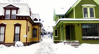
 Townhouses in Corn Hill
 -
 Oxford Street Houses
 -
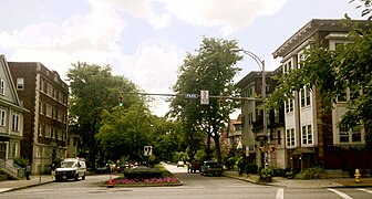 Park and Oxford
 -
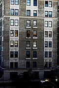 Apartments in Rochester's East End
 -
 Houses on Park Avenue
 -
 An aerial image of the city of Rochester taken in August 2007


.jpg)

19th Ward
The 19th Ward is a southwest neighborhood bordered by Genesee Street, West Avenue, and the Erie Canal, and is across the river from the University of Rochester. The neighborhood is one of the largest in Rochester.[65][66] Now known by its slogan "Urban by Choice",[67] in the early 19th century, the area was known as Castle Town, after Castle Inn, a tavern run by Colonel Isaac Castle. By the early 1820s, however, the area was overshadowed by developments in the north that would become downtown Rochester. Due to a tumultuous bend in the Genesee, the area was home to skilled boatsmen who assisted boats traveling north to Rochester and the area was consequently known during this time as "The Rapids".[68] In the 1890s, as Rochester expanded, the area rapidly urbanized. By 1930, it was a booming residential area for doctors, lawyers, and other skilled workers. Homes in the originally upper-class neighborhood typically have gumwood trim, leaded glass, fireplaces, hardwood floors, and open porches. In the 1960s, property values fell as the population of Rochester did, the area experienced white flight accelerated by school busing, blockbusting, and race riots downtown, and crime increased, with violence, drug use, and neglected property further diminishing property values.[69][page needed] In recent years, neighborhood revitalization has come from the "Brooks Landing" development along the Genesee River.[70] Gentrification has occurred in the 19th Ward and adjacent Plymouth-Exchange area from the conversion of housing stock to student housing for the University of Rochester.[71] Located in the 19th Ward are the Arvine Heights Historic District, Chili–West Historic District, Inglewood and Thurston Historic District, and Sibley–Elmdorf Historic District, listed on the National Register of Historic Places.[72][73][74]
Browncroft
The Browncroft neighborhood is built on the former nursery grounds of the Brown Brothers nursery, between the town of Brighton and Winton Road.[75] Many Tudor and Colonial houses are contained within, and the business district situated on Winton Road has a mix of restaurants and shops.[76] The Browncroft Historic District was listed on the National Register of Historic Places in 2004.[77]
Charlotte

Charlotte is a lakefront community in Rochester bordering Lake Ontario. It is home to Ontario Beach Park,[78] commonly known as Charlotte Beach, which is a popular summer destination for Rochesterians. A new terminal was built in 2004 for the Rochester-to-Toronto ferry service and was later sold after the ferry ceased operations in 2005. The Port of Rochester terminal still exists, but multiple attempts by the city to make additions have failed since 2016.[79][80]
Corn Hill
Corn Hill is located in the city's old Third Ward, and best known today for the annual Corn Hill arts festival. Many of the city's wealthiest residents lived in the neighborhood during the 19th century, but they relocated to the East End and suburbs after the turn of the century.[81] The neighborhood experienced decline, and much of the Third Ward was demolished for the construction of I-490 in the 1960s.[82] Revival began in the late 1960s, as several of the Victorian homes in the neighborhood were restored by the Genesee Landmarks Foundation. In 1969 the Corn Hill arts festival was held and became an annual feature.[81] The Third Ward Historic District was listed on the National Register of Historic Places in 1974.[77]
Edgerton
The Edgerton neighborhood is in the city's northwest quadrant, along Lake Avenue.[83] Historically an Italian-American neighborhood, the area around Lyell Avenue has been a target for the formation of a designated Little Italy neighborhood, although few Italian Americans live there today.[84][85][86] The neighborhood is known for struggling with a high crime rate. Residents have pursued a number of strategies to improve the neighborhood in recent years, including the construction of housing for the homeless.[86][87] The neighborhood features Edgerton Park, which was once home to most of the city's professional sports teams.[88][89]
Maplewood

Maplewood is located in the northwest quadrant, centered around Lake Avenue and Maplewood Park. Eastman Business Park is located on its north edge. The neighborhood once contained both mansions for the wealthy and worker housing for nearby factories like Kodak's.[90] Many of the neighborhood's old mansions have been converted to multi-family housing.[91] Due to its diverse architectural heritage, the Maplewood Historic District was listed on the National Register of Historic Places in 1997.[77]
Marketview Heights
The Marketview Heights neighborhood is northeast of downtown Rochester, running east from Union Street just north of Atlantic Ave.[92] It is best known as the location of the Public Market, which first opened in 1905 and offers a variety of groceries and other goods from farms and shops from surrounding areas, primarily on the weekends.[93] In the late twentieth century, the neighborhood experienced a severe decline, and roughly half of residents lived below the poverty line in 2000. Public investment was made in the neighborhood after 2008 to implement a number of community proposals.[94] A second round of proposals are being explored currently for the planned removal of the Inner Loop in the southern end of the neighborhood.[95]
Park Avenue
Park Avenue is centered on the eponymous street southeast of downtown. It originally functioned as a service street with businesses that catered to wealthy residents who lived on nearby East Avenue.[96] Between 1894 and 1975, it was also home to Park Avenue Hospital.[97] Today, the neighborhood is one of the most desirable in the city, highly valued for its walkability and density of bars, clubs, and restaurants.[96] The city's annual pride parade is hosted in the neighborhood.[98] The Park Avenue Historic District was listed on the National Register of Historic Places in 2020.[99]
South Wedge
The South Wedge is a wedge-shaped neighborhood centered on South Avenue between the Genesee River and Interstate 490. It began as the home of several families involved in trades on the Erie Canal. In the 1840s, the Ellwanger and Barry nursery was built on South Avenue, introducing greenery to the neighborhood and drawing tourists. Frederick Douglass lived in a house in the neighborhood. The area fell on hard times after World War II, when residents moved to the suburbs and several homes and businesses were abandoned. The South Wedge Planning Committee was established in 1973 to revitalize the neighborhood.[100] Today, the neighborhood is a hub of small businesses.[101] The South Wedge Historic District was listed on the National Register of Historic Places in 2013, and the Gregory Tract Historic District was listed in 2022.[77]
Climate
Rochester lies in the humid continental climate zone (Köppen: Dfa)[102] and has four distinct seasons.
Winters are cold (temperatures drop to 0 °F (−18 °C) on 4.2 nights annually). Like much of the eastern Great Lakes, Rochester is very cloudy and overcast in winter. Rochester normally receives heavy snow in winter (primarily lake effect snow resulting from its location on the southern shores of Lake Ontario), ranking among the snowiest large cities on earth[103] and occasionally setting records for annual snowfall among large US metros.[104] The 30-year annual average snowfall is just above 100 in (2.5 m).[105] Spring sees plentiful rain with the rising temperatures, and occasional late snowstorms depending on the year. Summers are warm and sunny; there are occasional short periods of high heat and humidity but in general, Rochester is set apart from most of the continental US by comparatively cool, comfortable summers (ranking among the top five coolest summers among large metros alongside San Francisco, Seattle, Portland, Oregon, and neighboring Buffalo[106]). Autumn features brilliant foliage colors, cooling temperatures and occasionally an excess of rain depending on the year, though precipitation is generally plentiful and dispersed fairly evenly throughout the year.
| Climate data for Rochester, New York (Greater Rochester Int'l), 1991–2020 normals,[a] extremes 1871−present[b] | |||||||||||||
|---|---|---|---|---|---|---|---|---|---|---|---|---|---|
| Month | Jan | Feb | Mar | Apr | May | Jun | Jul | Aug | Sep | Oct | Nov | Dec | Year |
| Record high °F (°C) | 74 (23) |
73 (23) |
86 (30) |
93 (34) |
94 (34) |
100 (38) |
102 (39) |
99 (37) |
99 (37) |
91 (33) |
81 (27) |
72 (22) |
102 (39) |
| Mean maximum °F (°C)
Zdroj:https://en.wikipedia.org?pojem=Rochester,_Monroe_County,_New_York Text je dostupný za podmienok Creative Commons Attribution/Share-Alike License 3.0 Unported; prípadne za ďalších podmienok. Podrobnejšie informácie nájdete na stránke Podmienky použitia.
Analytika
Antropológia Aplikované vedy Bibliometria Dejiny vedy Encyklopédie Filozofia vedy Forenzné vedy Humanitné vedy Knižničná veda Kryogenika Kryptológia Kulturológia Literárna veda Medzidisciplinárne oblasti Metódy kvantitatívnej analýzy Metavedy Metodika Text je dostupný za podmienok Creative
Commons Attribution/Share-Alike License 3.0 Unported; prípadne za ďalších
podmienok. www.astronomia.sk | www.biologia.sk | www.botanika.sk | www.dejiny.sk | www.economy.sk | www.elektrotechnika.sk | www.estetika.sk | www.farmakologia.sk | www.filozofia.sk | Fyzika | www.futurologia.sk | www.genetika.sk | www.chemia.sk | www.lingvistika.sk | www.politologia.sk | www.psychologia.sk | www.sexuologia.sk | www.sociologia.sk | www.veda.sk I www.zoologia.sk | |||||||||||||