

A | B | C | D | E | F | G | H | CH | I | J | K | L | M | N | O | P | Q | R | S | T | U | V | W | X | Y | Z | 0 | 1 | 2 | 3 | 4 | 5 | 6 | 7 | 8 | 9
| Wollongong New South Wales | |||||||||||||||
|---|---|---|---|---|---|---|---|---|---|---|---|---|---|---|---|
 Wollongong | |||||||||||||||
| Coordinates | 34°25′38″S 150°53′38″E / 34.427243°S 150.893915°E | ||||||||||||||
| Population | 280,153 (UCL 2021)[1][2] | ||||||||||||||
| Postcode(s) | 2500 | ||||||||||||||
| Elevation | 5 m (16 ft) | ||||||||||||||
| Area | 572.2 km2 (220.9 sq mi) | ||||||||||||||
| Time zone | AEST (UTC+10) | ||||||||||||||
| • Summer (DST) | AEDT (UTC+11) | ||||||||||||||
| Location | |||||||||||||||
| LGA(s) | |||||||||||||||
| Region | Illawarra | ||||||||||||||
| State electorate(s) | |||||||||||||||
| Federal division(s) | |||||||||||||||
| |||||||||||||||
| |||||||||||||||
.jpg)

.jpg)
.jpg)
.jpg)
.jpg)
Wollongong (/ˈwʊlənɡɒŋ/ WUUL-ən-gong; Dharawal: Woolyungah) is a city located in the Illawarra region of New South Wales, Australia. The name is believed to originate from the Dharawal language, meaning either 'five islands/clouds', 'ground near water' or 'sound of the sea'.[3] Wollongong lies on the narrow coastal strip between the Illawarra Escarpment and the Pacific Ocean, 85 kilometres (53 miles) south of central Sydney.[4] Wollongong had an estimated urban population of 302,739 at June 2018, making it the third-largest city in New South Wales after Sydney and Newcastle and the tenth-largest city in Australia by population.[5] The city's current Lord Mayor is Gordon Bradbery AM who was elected in 2021.[6]
The Wollongong area extends from Helensburgh in the north to Windang and Yallah in the south. Geologically, the city is located in the south-eastern part of the Sydney basin, which extends from Newcastle to Nowra.[7]
Wollongong is noted for its heavy industry, its port activity and the quality of its physical setting, occupying a narrow coastal plain between an almost continuous chain of surf beaches and the cliffline of the rainforest-covered Illawarra escarpment. It has two cathedrals, churches of many denominations and the Nan Tien Temple. Wollongong has a long history of coal mining and industry. The city attracts many tourists each year[8] and is a regional centre for the South Coast fishing industry. The University of Wollongong has around 38,000 students.[9]
History


The area was originally inhabited by the Dharawal Indigenous Australians. The first Europeans to visit the area were the navigators George Bass and Matthew Flinders, who landed at Lake Illawarra in 1796. The first settlers in the region were cedar cutters in the early nineteenth century, followed by graziers in 1812. Charles Throsby established a stockman's hut in the area in 1815. The first land grants were made in 1816. In 1830, a military barracks was constructed near the harbour. Further settlers arrived and in 1834 a town was planned. On 26 November 1834, the town was first gazetted and George Brown erected the first court house. The main road down the Escarpment through Bulli Pass was built by convict labour in 1835–6, although other passes were built during the 19th century as well, such as O'Briens Road and Rixons Pass. By 1856 Wollongong had a population of 864. In 1858, a court house was built. In 1861, a horse-drawn tramway from Mount Keira to the harbour was completed. In 1862 a telegraph line was opened between Wollongong and Bellambi. In 1865 the first gas supply in Wollongong was provided from a gas plant in Corrimal Street. In 1868 the extensions to the harbour were opened by Lady Belmore and named Belmore Basin. Patrick Lahiff established a coke works at Wollongong Harbour in the 1870s. He erected two beehive coke ovens between the north eastern end of the basin and Pulpit Rock. The ovens were demolished in 1892. The remains of the coke ovens were uncovered and recovered and are now preserved beneath the hill, with a plaque explaining their history.
.jpg)
In 1871 the old lighthouse was completed.[citation needed] Nevertheless, in 1881 a British clipper, Queen of Nations, ran ashore off the mouth of Towradgi Creek. Her cargo included 24,000 bottles of Hennessy Cognac. Local police and NSW Customs recovered at least 5,000 bottles, but others were looted by members of the public.[10]

The surviving part of the Queen of Nations wreck is only about 70 metres (230 ft) from the shore, in water only 3 to 5 metres (10 to 16 ft) deep. From time to time, a violent storm uncovers part of the wreck. After one such storm in 1991, looting resumed, including of the Cognac. The Commonwealth Government quickly issued an order protecting the wreck under the then Historic Shipwrecks Act 1976.[11] Since 2018 the Underwater Cultural Heritage Act 2018 has automatically protected the wreck and its contents, as they are more than 75 years old.


In 1880 steam locomotives were introduced to haul coal from Mount Keira mine to the harbour. Gas street lighting was introduced in 1883. In 1885 a new court house was erected in Market Street. Like many Australian court houses, it was designed in a Classical Revival style considered appropriate for public buildings. It is now listed on the Register of the National Estate.[12] In 1886 the first town hall was erected. The Illawarra Railway to Wollongong was completed in 1887, and now continues as far south as the town of Bomaderry on the Shoalhaven River. The navigator George Bass first documented the Illawarra coal deposits in 1797. There have been many coalmines in the district. Australia's worst coal mining disaster occurred in 1902, at the Mount Kembla mine when an explosion killed 94 men and boys, the youngest aged 14, the oldest 69. Two other men died attempting to rescue survivors. Survivors were treated at the "A. M. (Albert Memorial) Hospital",[13] which opened in 1864 and closed when the Wollongong Hospital opened in 1907[14] on Garden Hill. In 1916 the Wollongong High School was opened.
_(27197371454).jpg)
Heavy industry was attracted to the region by the ready availability of coal. In 1928, Hoskins, later Australian Iron & Steel, started a steelworks at Port Kembla, a few kilometres south of Wollongong. The former Broken Hill Proprietary Company (now BHP after merging with Billiton plc) acquired AI&S in 1935, but has since spun-out their steel division as a separate company, now known as BlueScope. The steelworks has grown to become a world-class flat rolled steel producer, operating as a fully integrated steel plant with a production of around 5 million tonnes per year. Other industries to have set up in the massive Port Kembla industrial complex—the largest single concentration of heavy industry in Australia—include a fertiliser plant, an electrolytic copper smelter, a locomotive workshop, a coal export shipping terminal, a grain export shipping terminal and an industrial gases manufacturing plant.

In 1936, the new Wollongong Lighthouse was finished on Flagstaff Point.[15] In 1942 Wollongong was proclaimed a City. In 1947 City of Greater Wollongong was formed. In 1954 the population of Wollongong was 90,852. In 1956 new Wollongong City Council Chambers were opened. In 1961 the Wollongong University College was established. In 1963, the Wollongong Teachers College was established. In 1965 the Westfield shopping centre at Figtree opened.
In 1985, the railway line was electrified to Wollongong, and in 1993 to Dapto. In 1986 the Wollongong Mall was completed. For a short while, trams (trackless trains) were used in the mall, though this ceased due to dangers involved. The mall was re-opened to traffic after the initial test but re-zoned a pedestrian area after and has remained one since.
In 1987 the council chambers and library building were completed, replacing the old council building at the present art gallery site. The Crown Gateway Shopping Centre was completed. Wollongong Mall was opened. In 1988, the current council administration building was completed, as well as the Illawarra Performing Arts Centre (IPAC), across the road on Burelli Street. IPAC was officially opened by Prince Charles and Princess Diana in 1988. [citation needed] A sculpture recognizing Lawrence Hargrave was placed via helicopter on the eastern foothills of Mount Keira. In 1998 the 6000 seat Wollongong Entertainment Centre was opened.
In 1999, the Gateway and Crown Central mall buildings were unified as Wollongong Central and a pedestrian walkway/café was built connecting the buildings in an above ground bridge. In 2000, as part of the Sydney Olympics, the Olympic torch was carried through Wollongong as part of its journey. In 2001, the population of Wollongong reached 181,612 people. In 2004 the Wollongong City Gallery celebrated its 25th anniversary. In 2005 Qantas established a daily air service from Wollongong to Melbourne that lasted till 2008.
In 2006/2007, the library was renovated, including new facilities, as part of the tenth anniversary of the library's current site. Also at this time the beachfront was renovated with a new lookout and walkway upgrade. In June 2007, erosion was caused via storms to the beaches, the worst in 30 years.
Despite the decline of traditional manufacturing and blue-collar industries due to the abandonment of protectionist economic policies in the 1980s, many of these industrial installations still exist. The city's economy is, however, on the rebound, thanks to diversification of economic activity including higher education, the fine arts, tourism, residential construction and eco-friendly electricity generation; however, the city's economy still relies primarily on heavy industry, and will continue to in the near future.
Various meanings are given for the Aboriginal word ' Wollongong' including 'seas of the South', ' great feast of fish' , 'hard ground near water', 'song of the sea' ' sound of the waves' 'many snakes' and ' five islands'.
In 2024, the wreck of a coal ship was discovered by accident, off the coast of Wollongong. The ship the SS Nemesis was sailing from Wollongong to Melbourne and it sank nearly 120 years ago. [16]¥
Heritage listings

Wollongong has a number of heritage-listed sites, including:
- Church Street: St Michael's Cathedral[17]
- Cliff Road: North Beach Precinct[18]
- Cliff Road and Endeavour Drive: Wollongong Harbour Precinct[19]
- 87 Crown Street: 87 Crown Street[20]
- 91 Crown Street: Old Wollongong East Post Office[21]
- Darling Street: Elouera House[22]
- Illawarra railway: Wollongong railway station[23]
- 197 Keira Street: Regent Theatre[24]
- 11 Market Street: Old Wollongong Telegraph and Post Office[25]
- 31–33 Smith Street: Little Milton[26]
Geography

The city of Wollongong has a distinct geography. It lies on a narrow coastal plain flanked by the Tasman Sea to the east and a steep sandstone precipice known as the Illawarra Escarpment to the west. The coastal plain is widest in the south and narrowest in the north, with the city centre located about midway. South of the city centre but within the urban area is Lake Illawarra, a large lagoon. Although Wollongong sits on the immediate coast, it lies on the same longitude as Greater Western Sydney.
The escarpment ranges between 150 and 750 metres (490–2,460 ft) above sea level, with locally famous mountains such as Mount Keira (464m), Mount Kembla (534m), Broker's Nose (440m) and Mount Murray (768m) to the south. It contains strata of coal measures, and the adit entrances to many coal mines have been established along the slopes of the escarpment throughout Wollongong. Suburbia encroaches on the escarpment's lower slopes in some areas, but the majority remains in a relatively natural state forested with dry sclerophyll and pockets of temperate rainforest. The escarpment is largely protected by a State Conservation Area and local scenic protection zoning, and provides the visual backdrop to the city.

In the north the escarpment meets the coastline, and north of this the coastal road Lawrence Hargrave Drive hugs the cliff line. The unstable geology of the escarpment resulted in rockfalls, forcing the closure of the road. Subsequently, part of Lawrence Hargrave Drive was replaced in 2005 by the Sea Cliff Bridge just off the coast, crossing the submerged rock shelf. The bridge carries both vehicular and pedestrian traffic. The Illawarra railway line must go through several tunnels to reach the Sydney metropolitan area. The Southern Freeway and Princes Highway provide alternative inland routes, descending the escarpment further south at Bulli Pass or at Mount Ousley, entering just north of Wollongong's city centre.
To the south the plain reaches its maximum extent around Albion Park where it incorporates a large coastal saltwater lagoon called Lake Illawarra, separated from the Pacific Ocean by a long sandy spit.

The coastal strip consists of highly fertile alluvium, which made Wollongong so attractive to agriculturists in the nineteenth century. It contains many hills including the foothills of the escarpment's lower slopes, and while these generally do not exceed one hundred metres in height they give much of the city an undulating character. The coastal strip is traversed by several short but flood-prone and fast-flowing streams and creeks such as Fairy Creek (Para Creek), Cabbage Tree Creek, Allans Creek, Nostaw Ravine, Jimbob Creek, Mullet Creek and Macquarie Rivulet.
The coastline consists of many beaches characterised by fine pale gold-coloured sands; however, these beaches are sometimes interrupted by prominent and rocky headlands, such as Tego Rock, jutting into the sea. In places these headlands have been excavated or extended to create artificial harbours at Wollongong, Port Kembla, Shellharbour and Kiama. Just off the coast south of Wollongong centre, near Port Kembla, lies a group of five islands known collectively as The Five Islands. The islands are a wildlife refuge.

Climate
Wollongong has an oceanic climate (Köppen: Cfb), bordering on humid subtropical (Cfa)[27] as its warmest month mean of 21.9 °C (71.4 °F) is just below the subtropical isotherm of 22 °C (72 °F). The highest recorded temperature is 44.1 °C on 1 January 2006, and the lowest 0.8 °C on 27 July 1986. Annually, Wollongong receives 107.4 clear days.[28]
Rainfall is spread through the months but has a bias to the first half of the year. It is often associated with orographic lift caused by the escarpment and its exposed location on the Tasman Sea, which makes it more prone to moist easterlies. A significant flood event occurred on 18 August 1998 when Wollongong recorded 316 mm of rainfall (the nearby suburb of Mt Ousley recorded in excess of 445 mm), mostly falling in a 3-hour period.[29][30] Wollongong also experiences thunderstorms during the warmer months bringing lightning, heavy rain and occasionally hail.
July and August are known as the windy months, with westerly gales that can gust at over 100 km/h.[28] These are generally dry foehn winds from the Great Dividing Range, which are common at this time of the year in southeast Australia on the leeward side of the Ranges.
| Climate data for Wollongong University | |||||||||||||
|---|---|---|---|---|---|---|---|---|---|---|---|---|---|
| Month | Jan | Feb | Mar | Apr | May | Jun | Jul | Aug | Sep | Oct | Nov | Dec | Year |
| Record high °C (°F) | 44.1 (111.4) |
41.7 (107.1) |
40.2 (104.4) |
35.4 (95.7) |
28.5 (83.3) |
24.7 (76.5) |
25.7 (78.3) |
30.3 (86.5) |
34.2 (93.6) |
38.8 (101.8) |
40.6 (105.1) |
41.5 (106.7) |
44.1 (111.4) |
| Mean daily maximum °C (°F) | 25.8 (78.4) |
25.8 (78.4) |
24.5 (76.1) |
22.6 (72.7) |
20.1 (68.2) |
17.9 (64.2) |
17.2 (63.0) |
18.6 (65.5) |
20.7 (69.3) |
22.5 (72.5) |
23.1 (73.6) |
24.9 (76.8) |
22.0 (71.6) |
| Mean daily minimum °C (°F) | 17.9 (64.2) |
18.1 (64.6) |
16.6 (61.9) |
13.8 (56.8) |
11.6 (52.9) |
9.6 (49.3) |
8.4 (47.1) |
8.6 (47.5) |
10.5 (50.9) |
12.5 (54.5) |
14.2 (57.6) |
16.3 (61.3) |
13.2 (55.8) |
| Record low °C (°F) | 9.6 (49.3) |
10.3 (50.5) |
9.1 (48.4) |
5.1 (41.2) |
3.1 (37.6) |
2.0 (35.6) |
0.8 (33.4) |
2.0 (35.6) |
3.3 (37.9) |
4.7 (40.5) |
5.4 (41.7) |
8.3 (46.9) |
0.8 (33.4) |
| Average rainfall mm (inches) | 130.3 (5.13) |
156.4 (6.16) |
160.4 (6.31) |
129.3 (5.09) |
106.4 (4.19) |
112.4 (4.43) |
63.4 (2.50) |
83.3 (3.28) |
67.4 (2.65) |
100.5 (3.96) |
115.6 (4.55) |
94.6 (3.72) |
1,320.9 (52.00) |
| Average rainy days | 13.8 | 13.7 | 14.5 | 11.2 | 10.8 | 9.7 | 8.5 | 7.8 | 9.3 | 11.4 | 13.6 | 13.0 | 137.3 |
| Average afternoon relative humidity (%) | 68 | 69 | 66 | 63 | 62 | 59 | 54 | 52 | 55 | 61 | 64 | 64 | 61 |
| Source: [28] | |||||||||||||
Urban structure

The inner city area includes the suburbs of Wollongong and North Wollongong, extending from Fairy Meadow in the north, west to include the Wollongong Hospital, and south to the Greenhouse Park. At the 2016 census, the suburb of Wollongong had a population of 18,442.[31]

The CBD is a major commercial hub containing many department stores and specialty shops, offices, and entertainment venues. It is centred on the Crown Street Mall and Wollongong Central, and approximates the area bounded by Market, Corrimal, and Burelli streets and the railway line. Surrounding the CBD lies a mixture of parks, reserves, light commercial property, houses and multi-story residential units. Multi-story housing is evident particularly on Smith's Hill, north-east of the CBD, reflecting the popularity of combining inner-city living, coastal views and a beachside lifestyle. To the east of the city lies Flagstaff Point, a rocky headland with eroded low cliffs topped by a grassy hill. The northern side of the point was excavated by convict labour to form Belmore Basin. This was later extended with the northern breakwater to create Wollongong Harbour. The area is the site of a historic colonial fort, several restored cannons and two lighthouses, a feature peculiar to the east coast of Australia. The older Wollongong Breakwater Lighthouse located at the harbour entrance was made of wrought iron plates in 1871 and has become an icon of the city. The newer Wollongong Head Lighthouse was constructed in 1936 atop the Flagstaff Hill and is still used in the early 21st century. Belmore Basin houses the commercial fishing fleet and Fisherman's Co-op, while the main harbour shelters private vessels.
The main beaches of central Wollongong are North Wollongong (or simply North ) Beach, extending from the harbour up to the Fairy lagoon and Puckeys Estate Reserve, and Wollongong City Beach, extending south from Flagstaff Point and into Coniston Beach.
Demographics
The Wollongong metropolitan area includes the suburbs, outlying towns and rural localities stretching from Helensburgh in the north to Kiama in the south. According to the 2021 census, it had a population of 305,691 people.
- Aboriginal and Torres Strait Islander people made up 3.6% of the population.
- 76.3% of people were born in Australia. The next most common countries of birth were England 3.9%, North Macedonia 1.3%, New Zealand 1.1%, Italy 0.9% and India 0.9%.
- 81.7% of people spoke only English at home. Other languages spoken at home included Macedonian 2.0%, Italian 1.1%, Arabic 1.1% , Mandarin 0.8%, and Spanish 0.8%.
- The most common responses for religion were No Religion 38.0%, Catholic 23.3% and Anglican 13.6%.
- 5.1% of employed people worked in Hospitals (except Psychiatric Hospitals). Other major industries of employment included Other Social Assistance Services 3.1%, Aged Care Residential Services 2.8%, Supermarket and Grocery Stores 2.6% and Takeaway Food Services 2.5%.[32]
-

-
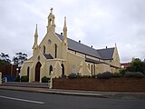 St Francis Xavier Cathedral
 -
 Nan Tien Temple


It is the third largest city in New South Wales and the tenth largest in Australia. Using 2006 ABS geography, around 89% of the statistical district's population reside in the built-up urban centre extending from Clifton to Shell Cove.[33][34][35]
Wollongong is continuing to grow with a population growth of 3.1% for the period 2001 to 2006, although the supply of new residential land is limited by the geography particularly in the northern suburbs. The west Dapto area is a major centre of future growth with plans for 19,000 new dwellings and 50,000 people within 40 years.[36][37] New residential areas are also being developed further south around the Albion Park, Shell Cove and Kiama areas.
| Wollongong Population Growth 1947–2010 (Statistical Local Area) | |||
|---|---|---|---|
| Year | Population | Increase | Growth |
| 1947 | 70,135 | ||
| 1954 | 100,725 | 30,590 | 43.6% |
| 1961 | 150,387 | 49,662 | 49.3% |
| 1966 | 177,432 | 27,045 | 18.0% |
| 1971 | 202,800 | 25,368 | 14.3% |
| 1976 | 222,250 | 19,450 | 9.6% |
| 1981 | 231,400 | 9,150 | 4.1% |
| 1986 | 232,240
Zdroj:https://en.wikipedia.org?pojem=Wollongong,_New_South_Wales Text je dostupný za podmienok Creative Commons Attribution/Share-Alike License 3.0 Unported; prípadne za ďalších podmienok. Podrobnejšie informácie nájdete na stránke Podmienky použitia.
Analytika
Antropológia Aplikované vedy Bibliometria Dejiny vedy Encyklopédie Filozofia vedy Forenzné vedy Humanitné vedy Knižničná veda Kryogenika Kryptológia Kulturológia Literárna veda Medzidisciplinárne oblasti Metódy kvantitatívnej analýzy Metavedy Metodika Text je dostupný za podmienok Creative
Commons Attribution/Share-Alike License 3.0 Unported; prípadne za ďalších
podmienok. www.astronomia.sk | www.biologia.sk | www.botanika.sk | www.dejiny.sk | www.economy.sk | www.elektrotechnika.sk | www.estetika.sk | www.farmakologia.sk | www.filozofia.sk | Fyzika | www.futurologia.sk | www.genetika.sk | www.chemia.sk | www.lingvistika.sk | www.politologia.sk | www.psychologia.sk | www.sexuologia.sk | www.sociologia.sk | www.veda.sk I www.zoologia.sk | ||