A | B | C | D | E | F | G | H | CH | I | J | K | L | M | N | O | P | Q | R | S | T | U | V | W | X | Y | Z | 0 | 1 | 2 | 3 | 4 | 5 | 6 | 7 | 8 | 9
Guadeloupe
Gwadloup (Guadeloupean Creole French) | |
|---|---|
| Anthem: La Marseillaise ("The Marseillaise") | |
 | |
 | |
| Coordinates: 16°15′N 61°30′W / 16.250°N 61.500°W | |
| Country | |
| Prefecture | Basse-Terre |
| Departments | 1 |
| Government | |
| • President of the Departmental Council | Guy Losbar[1] |
| • President of the Regional Council | Ary Chalus |
| Area | |
| • Total | 1,628 km2 (629 sq mi) |
| • Rank | 16th region |
| Highest elevation | 1,467 m (4,813 ft) |
| Population (1 Jan. 2024)[2] | |
| • Total | 378,561 |
| • Density | 230/km2 (600/sq mi) |
| Demonym | Guadeloupean |
| GDP | |
| • Total | €9.462 billion |
| • Per capita | €22,500 |
| Time zone | UTC-4:00 (AST) |
| ISO 3166 code | |
| Largest metropolitan area | Pointe-à-Pitre |
| Currency | Euro (€) (EUR) |
| Website | www www |
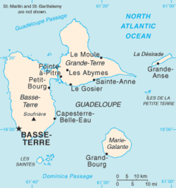
Guadeloupe (/ˌɡwɑːdəˈluːp/; French: [ɡwad(ə)lup] ; Guadeloupean Creole French: Gwadloup, IPA: [ɡwadlup]) is an overseas department of France in the Caribbean.[4] It consists of six inhabited islands—Basse-Terre, Grande-Terre, Marie-Galante, La Désirade, and two Îles des Saintes—as well as many uninhabited islands and outcroppings.[5] It is south of Antigua and Barbuda and Montserrat and north of Dominica. The capital city is Basse-Terre, on the southern west coast of Basse-Terre Island; the most populous city is Les Abymes and the main centre of business is neighbouring Pointe-à-Pitre, both on Grande-Terre Island.[4] It had a population of 395,726 in 2024.[2]
Like the other overseas departments, it is an integral part of France. As a constituent territory of the European Union and the Eurozone, the euro is its official currency and any European Union citizen is free to settle and work there indefinitely, but is not part of the Schengen Area. It included Saint Barthélemy and Saint Martin until 2007, when they were detached from Guadeloupe following a 2003 referendum.
Christopher Columbus visited Guadeloupe in 1493 and gave the island its name. The official language is French; Antillean Creole is also spoken.[4][5]
Etymology

The archipelago was called Karukera (or "The Island of Beautiful Waters") by the native Arawak people.[4]
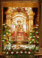
Christopher Columbus named the island Santa María de Guadalupe in 1493 after Our Lady of Guadalupe, a shrine to the Virgin Mary venerated in the Spanish town of Guadalupe, Extremadura.[4] When the area became a French colony, the Spanish name was retained - though altered to French orthography and phonology. The islands are locally known as Gwada.[6]
History
Pre-colonial era

The islands were first populated by indigenous peoples of the Americas, possibly as far back as 3000 BC.[7][8][9] The Arawak people are the first identifiable group, but they were later displaced c. 1400 by Kalina-Carib peoples.[4]
15th–17th centuries
Christopher Columbus was the first European to see Guadeloupe, landing in November 1493 and giving it its current name.[4] Several attempts at colonisation by the Spanish in the 16th century failed due to attacks from the native peoples.[4] In 1626, the French, under the trader and adventurer Pierre Belain d'Esnambuc, began to take an interest in Guadeloupe, expelling Spanish settlers.[4] The Compagnie des Îles de l'Amérique settled in Guadeloupe in 1635, under the direction of the French colonial leaders Charles Liénard de L'Olive and Jean du Plessis d'Ossonville; they formally took possession of the island for France and brought in French farmers to colonise the land. This led to the death of many indigenous people by disease and violence.[10] By 1640, however, the Compagnie des Îles de l'Amérique had gone bankrupt, and they thus sold Guadeloupe to Charles Houël du Petit Pré who began plantation agriculture, with the first African slaves arriving in 1650.[11][12] Slave resistance was immediately widespread, with an open uprising in 1656 lasting several weeks and a simultaneous spate of mass desertions that lasted at least two years until the French compelled indigenous peoples to stop assisting them.[13] Ownership of the island passed to the French West India Company before it was annexed to France in 1674 under the tutelage of their Martinique colony.[4] Institutionalised slavery, enforced by the Code Noir from 1685, led to a booming sugar plantation economy.[14]
18th–19th centuries
During the Seven Years' War, the British captured and occupied the islands until the 1763 Treaty of Paris.[4] During that time, Pointe-à-Pitre became a major harbour, and markets in Britain's North American colonies were opened to Guadeloupean sugar, which was traded for foodstuffs and timber. The economy expanded quickly, creating vast wealth for the French colonists.[15] So prosperous was Guadeloupe at the time that, under the 1763 Treaty of Paris, France forfeited its Canadian colonies in exchange for the return of Guadeloupe.[11][16] Coffee planting began in the late 1720s,[17] also worked by slaves and, by 1775, cocoa had become a major export product as well.[11]

The French Revolution brought chaos to Guadeloupe. Under new revolutionary law, freedmen were entitled to equal rights. Taking advantage of the chaotic political situation, Britain invaded Guadeloupe in 1794. The French responded by sending an expeditionary force led by Victor Hugues, who retook the islands and abolished slavery.[4] More than 1,000 French colonists were killed in the aftermath.[15]

In 1802, the French Consulate government reinstated the pre-revolutionary government and slavery, prompting a slave rebellion led by Louis Delgrès.[4] The French authorities responded quickly, culminating in the Battle of Matouba on 28 May 1802. Realising they had no chance of success, Delgrès and his followers committed mass suicide by deliberately exploding their gunpowder stores.[18][19] In 1810, the British captured the island again, handing it over to Sweden under the 1813 Treaty of Stockholm.[20]
In the 1814 Treaty of Paris, Sweden ceded Guadeloupe to France, giving rise to the Guadeloupe Fund. In 1815, the Treaty of Vienna acknowledged French control of Guadeloupe.[4][11]
Slavery was abolished in the French Empire in 1848.[4] After 1854, indentured labourers from the French colony of Pondicherry in India were brought in.[21] Emancipated slaves had the vote from 1849, but French nationality and the vote were not granted to Indian citizens until 1923, when a long campaign, led by Henry Sidambarom, finally achieved success.[22]
20th–21st centuries
In 1936, Félix Éboué became the first black governor of Guadeloupe.[23] During the Second World War Guadeloupe initially came under the control of the Vichy government, later joining Free France in 1943.[4] In 1946, the colony of Guadeloupe became an overseas department of France.[4]
Tensions arose in the post-war era over the social structure of Guadeloupe and its relationship with mainland France. The 'Massacre of St Valentine' occurred in 1952, when striking factory workers in Le Moule were shot at by the Compagnies républicaines de sécurité, resulting in four deaths.[24][25][26] In May 1967 racial tensions exploded into rioting following a racist attack on a black Guadeloupean, Raphael Balzinc,[27] resulting in eight deaths.[28][29][30]
An independence movement grew in the 1970s, prompting France to declare Guadeloupe a French region in 1974.[4] The Union populaire pour la libération de la Guadeloupe (UPLG) campaigned for complete independence, and by the 1980s the situation had turned violent with the actions of groups such as Groupe de libération armée (GLA) and Alliance révolutionnaire caraïbe (ARC).
Greater autonomy was granted to Guadeloupe in 2000.[4] Through a referendum in 2003, Saint-Martin and Saint Barthélemy voted to separate from the administrative jurisdiction of Guadeloupe, this being fully enacted by 2007.[4]
In January 2009, labour unions and others known as the Liyannaj Kont Pwofitasyon went on strike for more pay.[31] Strikers were angry with low wages, the high cost of living, high levels of poverty relative to mainland France and levels of unemployment that are amongst the worst in the European Union.[32] The situation quickly escalated, exacerbated by what was seen as an ineffectual response by the French government, turning violent and prompting the deployment of extra police after a union leader (Jacques Bino) was shot and killed.[33] The strike lasted 44 days and had also inspired similar actions on nearby Martinique. President Nicolas Sarkozy later visited the island, promising reform.[34] Tourism suffered greatly during this time and affected the 2010 tourist season as well.
Geography
This article or section may need to be cleaned up or summarized because it has been split from/to Geography of Guadeloupe. |


Guadeloupe is an archipelago of more than 12 islands, as well as islets and rocks situated where the northeastern Caribbean Sea meets the western Atlantic Ocean.[4] It is located in the Leeward Islands in the northern part of the Lesser Antilles, a partly volcanic island arc. To the north lie Antigua and Barbuda and the British Overseas Territory of Montserrat, with Dominica lying to the south.
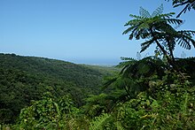
The two main islands are Basse-Terre (west) and Grande-Terre (east), which form a butterfly shape as viewed from above, the two 'wings' of which are separated by the Grand Cul-de-Sac Marin, Rivière Salée and Petit Cul-de-Sac Marin. More than half of Guadeloupe's land surface consists of the 847.8 km2 Basse-Terre.[35] The island is mountainous, containing such peaks as Mount Sans Toucher (4,442 feet; 1,354 metres) and Grande Découverte (4,143 feet; 1,263 metres), culminating in the active volcano La Grande Soufrière, the highest mountain peak in the Lesser Antilles with an elevation of 1,467 metres (4,813 ft).[4][5] In contrast Grande-Terre is mostly flat, with rocky coasts to the north, irregular hills at the centre, mangrove at the southwest, and white sand beaches sheltered by coral reefs along the southern shore.[5] This is where the main tourist resorts are found.[36]
Marie-Galante is the third-largest island, followed by La Désirade, a north-east slanted limestone plateau, the highest point of which is 275 metres (902 ft). To the south lies the Îles de Petite-Terre, which are two islands (Terre de Haut and Terre de Bas) totalling 2 km2.[36]
Les Saintes is an archipelago of eight islands of which two, Terre-de-Bas and Terre-de-Haut are inhabited. The landscape is similar to that of Basse-Terre, with volcanic hills and irregular shoreline with deep bays.
There are numerous other smaller islands.
Geology
Basse-Terre is a volcanic island.[37] The Lesser Antilles are at the outer edge of the Caribbean Plate, and Guadeloupe is part of the outer arc of the Lesser Antilles Volcanic Arc. Many of the islands were formed as a result of the subduction of oceanic crust of the Atlantic Plate under the Caribbean Plate in the Lesser Antilles subduction zone. This process is ongoing and is responsible for volcanic and earthquake activity in the region. Guadeloupe was formed from multiple volcanoes, of which only La Grande Soufrière is not extinct.[38] Its last eruption was in 1976, and led to the evacuation of the southern part of Basse-Terre. 73,600 people were displaced throughout three and a half months following the eruption.
K–Ar dating indicates that the three northern massifs on Basse-Terre Island are 2.79 million years old. Sections of volcanoes collapsed and eroded within the last 650,000 years, after which the Sans Toucher volcano grew in the collapsed area. Volcanoes in the north of Basse-Terre Island mainly produced andesite and basaltic andesite.[39] There are several beaches of dark or "black" sand.[36]
La Désirade, east of the main islands, has a basement from the Mesozoic, overlaid with thick limestones from the Pliocene to Quaternary periods.[40]
Grande-Terre and Marie-Galante have basements probably composed of volcanic units of Eocene to Oligocene, but there are no visible outcrops. On Grande-Terre, the overlying carbonate platform is 120 metres thick.[40]
Climate
The islands are part of the Leeward Islands, so called because they are downwind of the prevailing trade winds, which blow out of the northeast.[4][5] This was significant in the days of sailing ships. Grande-Terre is so named because it is on the eastern, or windward side, exposed to the Atlantic winds. Basse-Terre is so named because it is on the leeward south-west side and sheltered from the winds. Guadeloupe has a tropical climate tempered by maritime influences and the Trade Winds. There are two seasons, the dry season called "Lent" from January to June, and the wet season called "winter", from July to December.[4]
| Climate data for Guadeloupe | |||||||||||||
|---|---|---|---|---|---|---|---|---|---|---|---|---|---|
| Month | Jan | Feb | Mar | Apr | May | Jun | Jul | Aug | Sep | Oct | Nov | Dec | Year |
| Mean daily maximum °C (°F) | 29.1 (84.4) |
29.1 (84.4) |
29.4 (84.9) |
30.1 (86.2) |
30.7 (87.3) |
31.3 (88.3) |
31.5 (88.7) |
31.6 (88.9) |
31.5 (88.7) |
31.2 (88.2) |
30.5 (86.9) |
29.6 (85.3) |
30.5 (86.9) |
| Daily mean °C (°F) | 24.5 (76.1) |
24.5 (76.1) |
24.9 (76.8) |
25.9 (78.6) |
26.9 (80.4) |
27.5 (81.5) |
27.6 (81.7) |
27.7 (81.9) |
27.4 (81.3) |
27.0 (80.6) |
26.3 (79.3) |
25.2 (77.4) |
26.3 (79.3) |
| Mean daily minimum °C (°F) | 19.9 (67.8) |
19.9 (67.8) |
20.4 (68.7) |
21.7 (71.1) |
23.1 (73.6) |
23.8 (74.8) |
23.8 (74.8) |
23.7 (74.7) |
23.3 (73.9) |
22.9 (73.2) |
22.1 (71.8) |
20.9 (69.6) |
22.1 (71.8) |
| Average precipitation mm (inches) | 84 (3.3) |
64 (2.5) |
73 (2.9) |
123 (4.8) |
148 (5.8) |
118 (4.6) |
150 (5.9) |
198 (7.8) |
236 (9.3) |
228 (9.0) |
220 (8.7) |
137 (5.4) |
1,779 (70.0) |
| Average precipitation days | 15.0 | 11.5 | 11.5 | 11.6 | 13.6 | 12.8 | 15.4 | 16.2 | 16.6 | 18.1 | 16.6 | 15.7 | 174.6 |
| Mean monthly sunshine hours | 235.6 | 229.1 | 232.5 | 240.0 | 244.9 | 237.0 | 244.9
Zdroj:https://en.wikipedia.org?pojem=Administrative_divisions_of_Guadeloupe Text je dostupný za podmienok Creative Commons Attribution/Share-Alike License 3.0 Unported; prípadne za ďalších podmienok. Podrobnejšie informácie nájdete na stránke Podmienky použitia.
Analytika
Antropológia Aplikované vedy Bibliometria Dejiny vedy Encyklopédie Filozofia vedy Forenzné vedy Humanitné vedy Knižničná veda Kryogenika Kryptológia Kulturológia Literárna veda Medzidisciplinárne oblasti Metódy kvantitatívnej analýzy Metavedy Metodika Text je dostupný za podmienok Creative
Commons Attribution/Share-Alike License 3.0 Unported; prípadne za ďalších
podmienok. www.astronomia.sk | www.biologia.sk | www.botanika.sk | www.dejiny.sk | www.economy.sk | www.elektrotechnika.sk | www.estetika.sk | www.farmakologia.sk | www.filozofia.sk | Fyzika | www.futurologia.sk | www.genetika.sk | www.chemia.sk | www.lingvistika.sk | www.politologia.sk | www.psychologia.sk | www.sexuologia.sk | www.sociologia.sk | www.veda.sk I www.zoologia.sk | ||||||

