

A | B | C | D | E | F | G | H | CH | I | J | K | L | M | N | O | P | Q | R | S | T | U | V | W | X | Y | Z | 0 | 1 | 2 | 3 | 4 | 5 | 6 | 7 | 8 | 9
Bermuda | |
|---|---|
| Motto: | |
| Anthem: "God Save the King" | |
| National song: "Hail to Bermuda" | |
_(Americas_centered).svg)  | |
| Sovereign state | |
| English settlement | 1609 (officially becoming part of the Colony of Virginia in 1612) |
| Capital and largest city | Hamilton 32°17′46″N 64°46′58″W / 32.29611°N 64.78278°W |
| Official languages | English |
| Ethnic groups (2016[2]) |
|
| Demonym(s) |
|
| Government | Parliamentary dependency under a constitutional monarchy |
• Monarch | Charles III |
• Governor | Rena Lalgie |
• Premier | Edward David Burt |
| Legislature | Parliament |
| Senate | |
| House of Assembly | |
| Government of the United Kingdom | |
• Minister | David Rutley |
| Area | |
• Total | 53.2 km2 (20.5 sq mi) |
• Water (%) | 27 |
| Highest elevation | 79 m (259 ft) |
| Population | |
• 2019 estimate | 63,913[3] (205th) |
• 2016 census | 63,779 |
• Density | 1,338/km2 (3,465.4/sq mi) (10th) |
| GDP (nominal) | 2019 estimate |
• Total | US$7.484 billion[3] (161st) |
• Per capita | US$117,097 (4th) |
| HDI (2013) | very high |
| Currency | Bermudian dollar (BMD) |
| Time zone | UTC−04:00 (AST[a]) |
• Summer (DST) | UTC−03:00 (ADT) |
| Date format | dd/mm/yyyy |
| Driving side | left |
| Calling code | +1-441 |
| Postal codes | CR01 to CR04, DD01 to DD03, DV01 to DV08, FL01 to FL08, GE01 to GE05, GECX, HM01 to HM20, HS01, HS02, MA01 to MA06, PG01 to PG06, SB01 to SB04, SN01 to SN04, WK01 to WK10[5] |
| ISO 3166 code | |
| Internet TLD | .bm |
| Website | https://www.gov.bm/ |


Bermuda (/bərˈmjuːdə/; historically known as the Bermudas or Somers Isles) is a British Overseas Territory in the North Atlantic Ocean. The closest land outside the territory is in the American state of North Carolina, about 1,035 km (643 mi) to the west-northwest.
Bermuda is an archipelago consisting of 181 islands, although the most significant islands are connected by bridges and appear to form one landmass. It has a land area of 54 square kilometres (21 sq mi). Bermuda has a sub-tropical climate, with mild winters and warm summers. Its climate also exhibits oceanic features similar to other coastal areas in the Northern Hemisphere with warm, moist air from the ocean ensuring relatively high humidity and stabilising temperatures. Bermuda lies in Hurricane Alley and thus is prone to severe weather; however, it receives some protection from a coral reef and its position at the north of the belt, which limits the direction and severity of approaching storms.
Bermuda is named after Spanish explorer Juan de Bermúdez, who discovered the archipelago in 1505. The islands have been permanently inhabited since 1612 when an English settlement was established at St. George's. Forming part of British America, Bermuda was governed under Royal charter by the Somers Isles Company until 1684, when it became a crown colony. The first enslaved Africans were taken to Bermuda in 1616. The Somers Isles Company ensured a steady flow of free but indentured servants until 1684, and most tobacco farms owned by overseas adventurers were sold to the tenants or other occupants after Bermuda-grown tobacco became steadily less profitable following the 1620s, becoming family farms that switched from growing tobacco for export to producing food (initially for local consumption).[6] Consequently, a plantation economy did not develop and the slave trade largely ceased by the end of the 17th century.[7] The economy instead became maritime-focused, with the colony serving as a base for merchants, privateers and the Royal Navy, giving its name to the Bermuda rig and Bermuda sloop. It became an imperial fortress, the most important British naval and military base in the western hemisphere with vast funds lavished on its Royal Naval Dockyard and military defences until the 1950s. Tourism has been a significant contributor to Bermuda's economy since the 19th century and after World War II, the territory became a prominent offshore financial centre and tax haven.
Divided into nine parishes, Bermuda is a self-governing parliamentary democracy with a bicameral parliament located in the capital Hamilton. The House of Assembly dates from 1620, making it one of the world's oldest legislatures. The premier is the head of government and is formally appointed by the governor, who is nominated by the British government as the representative of the King. The United Kingdom is responsible for foreign affairs and defence. An independence referendum was held in 1995 with a large majority voting against independence. As of 2019, Bermuda had a population of around 64,000 people, making it the second-most populous of the British Overseas Territories. Black Bermudians, a diverse population primarily of any mixture of African, European, and Native American ancestry,[8][9] make up around 50% of the population, while White Bermudians, primarily of British, Irish and Portuguese descent, make up 30% of the population. There are smaller groups from other races or identifying as mixed race and about 30% of the population is not Bermudian by birth. The last remaining colony in the former British North America (following the 1867 Confederation of Canada and the Colony of Newfoundland becoming the Dominion of Newfoundland in 1907), Bermuda has a distinct dialect of English and has historically had strong ties with other English-speaking countries in the Americas, including the United States, Canada, and the Commonwealth Caribbean. It is an associate member of the Caribbean Community.
Etymology
Bermuda is named after the Spanish sailor Juan de Bermúdez, who discovered the islands in 1505,[1] while sailing for Spain from a provisioning voyage to Hispaniola in the ship La Garça.
History
Discovery

Bermuda was discovered in the early 1500s by Spanish explorer Juan de Bermúdez.[10][11][page needed] Bermuda had no Indigenous population when it was discovered, nor during initial British settlement a century later.[12] It was mentioned in Legatio Babylonica, published in 1511 by historian Pedro Mártir de Anglería, and was included on Spanish charts of that year.[13] Both Spanish and Portuguese ships used the islands as a replenishment spot to take on fresh meat and water. Shipwrecked Portuguese mariners are now thought to have been responsible for the 1543 inscription on Portuguese Rock, previously called Spanish Rock.[14] Legends arose of spirits and devils, now thought to have stemmed from the calls of raucous birds (most likely the Bermuda petrel, or cahow)[15] and loud nocturnal noises from wild hogs.[16] With its frequent storm-racked conditions and dangerous reefs, the archipelago became known as the "Isle of Devils".[17] Neither Spain nor Portugal attempted to settle it.
Settlement by the English

For the next century, the island was frequently visited but not settled. The English began to focus on the New World, initially settling in Virginia, starting British colonization in North America, establishing a colony at Jamestown, Virginia in 1607. Two years later, a flotilla of seven ships left England with several hundred settlers, food, and supplies to relieve the Jamestown colony.[18] However, the flotilla was broken up by a storm and the flagship, the Sea Venture, drove onto Bermuda's reef to prevent her sinking, resulting in the survival of all her passengers and crew.[19][10] The settlers were unwilling to move on, having now heard about the true conditions in Jamestown from the sailors, and made multiple attempts to rebel and stay in Bermuda. They argued that they had a right to stay and establish their own government. The new settlement became a prison labour camp, and built two ships, the Deliverance and the Patience.[20]
In 1612, the English began settlement of the archipelago, officially named Virgineola,[21] with arrival of the ship the Plough. New London (renamed St. George's Town) was settled that year and designated as the colony's first capital.[22][13] It is the oldest continuously inhabited English town in the New World.[22]
In 1615, the colony, which had been renamed the Somers Isles in commemoration of Sir George Somers, was passed on to the Somers Isles Company.[23][24] As Bermudians settled the Carolina Colony and contributed to establishing other English colonies in the Americas, several other locations were named after the archipelago. During this period the first slaves were held and trafficked to the islands. These were a mixture of native Africans who were trafficked to the Americas via the African slave trade and Native Americans who were enslaved from the Thirteen Colonies.[10]
The archipelago's limited land area and resources led to the creation of what may be the earliest conservation laws of the New World. In 1616 and 1620 acts were passed banning the hunting of certain birds and young tortoises.[25]
Civil War

In 1649, the English Civil War was taking place and King Charles I was beheaded in Whitehall, London. The conflict spilled over into Bermuda, where most of the colonists developed a strong sense of devotion to the Crown. The royalists ousted the Somers Isles Company's Governor and elected John Trimingham as their leader (see Governor of Bermuda). Bermuda's civil war was ended by militias, and dissenters were pushed to settle The Bahamas under William Sayle.[26]
The rebellious royalist colonies of Bermuda, Virginia, Barbados and Antigua, were the subjects of an Act of the Rump Parliament of England.[27] The royalist colonies were also threatened with invasion. The Government of Bermuda eventually reached an agreement with the Parliament of England which retained the status quo in Bermuda.
Later 17th century

In the 17th century, the Somers Isles Company suppressed shipbuilding, as it needed Bermudians to farm in order to generate income from the land. The Virginia colony, however, far surpassed Bermuda in quality and quantity of tobacco produced. Bermudians began to turn to maritime trades relatively early in the 17th century, but the Somers Isles Company used all its authority to suppress turning away from agriculture. This interference led to islanders demanding, and receiving, revocation of the company's charter in 1684, and the company was dissolved.[10]
Bermudians rapidly abandoned agriculture for shipbuilding, replanting farmland with the native juniper trees (Juniperus bermudiana, called Bermuda cedar). Establishing effective control over the Turks Islands, Bermudians deforested their landscape to begin the salt trade. It became the world's largest and remained the cornerstone of Bermuda's economy for the next century. Bermudians also vigorously pursued whaling, privateering, and the merchant trade.
Some islanders, especially in St David's, still trace their ancestry to Native Americans, and many more are ignorant of having such ancestry. Hundreds of Native Americans were shipped to Bermuda. The best-known examples were the Algonquian peoples such as (Pequots, Wampanoags, Podunks, Nipmucks, Narragansetts,...), who were exiled from the New England colonies and sold into slavery in the seventeenth century, notably in the aftermaths of the Pequot War and King Philip's War, but some are believed to have been brought from as far away as Mexico.
The American War of Independence
Bermuda's ambivalence towards the American rebellion changed in September 1774, when the Continental Congress resolved to ban trade with Great Britain, Ireland, and the West Indies after 10 September 1775. Such an embargo would mean the collapse of their inter-colonial commerce, famine and civil unrest. Lacking political channels with Great Britain, the Tucker Family met in May 1775 with eight other parishioners and resolved to send delegates to the Continental Congress in July, aiming for an exemption from the ban. Henry Tucker noted a clause in the ban which allowed the exchange of American goods for military supplies. The clause was confirmed by Benjamin Franklin when Tucker met with the Pennsylvania Committee of Safety. Independently, others confirmed this business arrangement with Peyton Randolph, the Charlestown Committee of Safety, and George Washington.[28]
Three American boats, operating from Charlestown, Philadelphia and Newport, sailed to Bermuda, and on 14 August 1775, 100 barrels of gunpowder were taken from the Bermudian magazine while Governor George James Bruere slept, and loaded onto these boats. As a consequence, on 2 October the Continental Congress exempted Bermuda from their trade ban, and Bermuda acquired a reputation for disloyalty. Later that year, the British Parliament passed the Prohibitory Act to prohibit trade with the American rebelling colonies and sent HMS Scorpion to keep watch over the island. The island's forts were stripped of cannons. Yet, wartime trade of contraband continued along well-established family connections. With 120 boats by 1775, Bermuda continued to trade with St. Eustatius until 1781 and provided salt to North American ports.[28]: 389–415
In June 1776, HMS Nautilus secured the island, followed by HMS Galatea in September. Yet, the two British captains seemed more intent on capturing prize money, causing a severe food shortage on the island until the departure of Nautilus in October. After France's entry into the war in 1778, Henry Clinton refortified the island under the command of Major William Sutherland. As a result, 91 French and American ships were captured in the winter of 1778–1779, bringing the population once again to the brink of starvation. Bermudian trade was severely hampered by the combined efforts of the Royal Navy, the British garrison and loyalist privateers, such that famine struck the island in 1779.[28]: 416–427
Upon the death of George Bruere in 1780, the governorship passed to his son, George Jr., an active loyalist. Under his leadership, smuggling was stopped, and the Bermudian colonial government was populated with like-minded loyalists. Even Henry Tucker abandoned trading with the United States, because of the presence of many privateers.[28]: 428–433
The Bermuda Gazette, Bermuda's first newspaper, began publishing in 1784.[29][30][31] The editor, Joseph Stockdale, had been given financial incentive to move to Bermuda with his family and establish the newspaper. He also provided other printing services and operated Bermuda's first local postal service. The Bermuda Gazette was sold by subscription and delivered to subscribers, with Stockdale's employee also delivering mail for a fee.[32]
19th century
.png)
After the American Revolution, the Royal Navy began improving the harbours on the Bermudas. In 1811, work began on the large Royal Naval Dockyard on Ireland Island, which was to serve as the islands' principal naval base guarding the western Atlantic Ocean shipping lanes. To guard the dockyard, the British Army built the Bermuda Garrison, and heavily fortified the archipelago.
During the War of 1812 between Britain and the United States, the British attacks on Washington, D.C., and the Chesapeake were planned and launched from Bermuda, where the headquarters of the Royal Navy's North American Station had recently been moved from Halifax, Nova Scotia.[33]

In 1816, James Arnold, the son of Benedict Arnold, fortified Bermuda's Royal Naval Dockyard against possible US attacks.[34] Today, the National Museum of Bermuda, which incorporates Bermuda's Maritime Museum, occupies the Keep of the Royal Naval Dockyard.
Due to its proximity to the southeastern US coast, Bermuda was frequently used during the American Civil War as a stopping point base for the Confederate States' blockade runners on their runs to and from the Southern states, and England, to evade Union naval vessels on blockade patrol.[13][10] The blockade runners were then able to transport essential war goods from England and deliver valuable cotton back to England. The old Globe Hotel in St. George's, which was a centre of intrigue for Confederate agents, is preserved as a public museum.
Anglo-Boer War
During the Anglo-Boer War (1899–1902), 5,000 Boer prisoners of war were housed on five islands of Bermuda. They were located according to their views of the war. "Bitterenders" (Afrikaans: Bittereinders), who refused to pledge allegiance to the British Crown, were interned on Darrell's Island and closely guarded. Other islands such as Morgan's Island held 884 men, including 27 officers; Tucker's Island held 809 Boer prisoners, Burt's Island 607, and Port's Island held 35. Hinson's Island housed underage prisoners. The camp cemetery is on Long Island.[35]
The New York Times reported an attempted mutiny by Boer prisoners of war en route to Bermuda and that martial law was enacted on Darrell's Island.[36]
The most famous escapee was the Boer prisoner of war Captain Fritz Joubert Duquesne, who was serving a life sentence for "conspiracy against the British government and on (the charge of) espionage".[37] On the night of 25 June 1902, Duquesne slipped out of his tent, worked his way over a barbed-wire fence, swam 1.5 miles (2.4 km) past patrol boats and bright spotlights, through storm-swept waters, using the distant Gibbs Hill Lighthouse for navigation until he arrived ashore on the main island.[38] He settled in the U.S. and later became a spy for Germany in both World Wars. In 1942, Col. Duquesne was arrested by the FBI for leading the Duquesne Spy Ring, which to this day remains the largest espionage case uncovered in the history of the United States.[39]
20th and 21st centuries


In the early 20th century Bermuda became a popular destination for American, Canadian and British tourists arriving by sea. The US Smoot–Hawley Tariff Act of 1930, which enacted protectionist trade tariffs on goods imported into the US, led to the demise of Bermuda's once-thriving agricultural export trade to America and encouraged development of tourism as an alternative source of income. The island was one of the centres for illegal alcohol smuggling during the era of Prohibition in the United States (1920–1933).[13][10]
A rail line was constructed in Bermuda in the 1920s, opening in 1931 as the Bermuda Railway, which was abandoned in 1948.[40] The right of way is now the Bermuda Railway Trail.[41]
In 1930, after several failed attempts, a Stinson Detroiter seaplane flew to Bermuda from New York City: It was the first aeroplane ever to reach the islands. In 1936, Deutsche Luft Hansa began to experiment with seaplane flights from Berlin via the Azores with continuation flights to New York City.[42]
In 1937, Imperial Airways and Pan American Airways began operating scheduled flying boat airline services from New York and Baltimore to Darrell's Island, Bermuda. In World War II, the Hamilton Princess Hotel became a censorship centre. All mail, radio and telegraphic traffic bound for Europe, the US and the Far East was intercepted and analysed by 1,200 censors, of British Imperial Censorship, part of British Security Coordination (BSC), before being routed to their destination.[43][44] With BSC working closely with the FBI, the censors were responsible for the discovery and arrest of a number of Axis spies operating in the US, including the Joe K ring.[45]
In 1948, a regularly scheduled commercial airline service began to operate, using land-based aeroplanes landing at Kindley Field (now L.F. Wade International Airport), helping tourism to reach a peak in the 1960s and 1970s. By the end of the 1970s, however, international business had supplanted tourism as the dominant sector of Bermuda's economy.
The Royal Naval Dockyard and its attendant military garrison remained important to Bermuda's economy until the mid-20th century. In addition to considerable building work, the armed forces needed to source food and other materials from local vendors. Beginning in World War II, US military installations were also located in Bermuda, including a naval air station, and submarine base. The American military presence lasted until 1995.[46]
Universal adult suffrage and development of a two-party political system took place in the 1960s.[10] Universal suffrage was adopted as part of Bermuda's Constitution in 1967; voting had previously been dependent on a certain level of property ownership.
On 10 March 1973, the governor of Bermuda, Richard Sharples, was assassinated by local Black Power militants during a period of civil unrest.[10] Some moves were made towards possible independence for the islands, however, this was decisively rejected in a referendum in 1995.[10]
At the 2020 Summer Olympics, Bermuda became the smallest overseas territory to earn a gold medal, as Flora Duffy won Bermuda's first ever Olympic gold medal in the women's triathlon.[47]
Geography


Bermuda is a group of low-forming volcanoes in the Atlantic Ocean, in the west of the Sargasso Sea, roughly 578 nmi (1,070 km; 665 mi) east-southeast of Cape Hatteras[48] on the Outer Banks of North Carolina, United States which is the nearest landmass.[1][49] Its next nearest neighbour is Cape Sable Island, Nova Scotia Canada which is 1,236 km (768 mi) north of Bermuda. It is also located 1,759 km (1,093 mi) north-northeast of Havana, Cuba, 1,538 km (956 mi) north of the British Virgin Islands, and 1,537.17 km (955.15 mi) north of San Juan, Puerto Rico.
The territory consists of 181 islands, with a total area of 53.3 km2 (20.6 sq mi).[50] The largest island is Main Island (also called Bermuda). Eight larger and populated islands are connected by bridges.[50] The territory's tallest peak is Town Hill on Main Island at 79 m (259 ft) tall.[1][51] The territory's coastline is 103 km (64 mi).[1]
Bermuda gives its name to the Bermuda Triangle, a region of sea in which, according to legend, a number of aircraft and boats have disappeared under unexplained or mysterious circumstances.[52]
Main sights
Bermuda's pink sand beaches and clear, cerulean blue ocean waters are popular with tourists.[53] Many of Bermuda's hotels are located along the south shore of the island. In addition to its beaches, there are a number of sightseeing attractions. Historic St. George's is a designated World Heritage Site. Scuba divers can explore numerous wrecks and coral reefs in relatively shallow water (typically 30–40 ft or 9–12 m in depth), with virtually unlimited visibility. Many nearby reefs are readily accessible from shore by snorkellers, especially at Church Bay.
Bermuda's most popular visitor attraction is the Royal Naval Dockyard, which includes the National Museum of Bermuda.[54] Other attractions include the Bermuda Aquarium, Museum and Zoo,[55] Bermuda Underwater Exploration Institute, the Botanical Gardens and Masterworks Museum of Bermuda Art, lighthouses, and the Crystal Caves with stalactites and underground saltwater pools.
Non-residents are prohibited from driving cars on the island.[56] Public transport and taxis are available or visitors can rent scooters for use as private transport.[50]
Geology

Bermuda consists of over 150 limestone islands, but especially five main islands, along the southern margin of the Bermuda Platform, one of three topographic highs found on the Bermuda Pedestal. This Bermuda Pedestal sits atop the Bermuda Rise, a mid-basin swell surrounded by abyssal plains. The Bermuda Pedestal is one of four topographic highs aligned roughly from North-East to South-West. The others, all submerged, being Bowditch Seamount to the North-East, and Challenger Bank and Argus Bank to the South-West.[57] Initial uplift of this rise occurred in the Middle to Late Eocene and concluded by the Late Oligocene, when it subsided below sea level. The volcanic rocks associated with this rise are tholeiitic lavas and intrusive lamprophyre sheets, which form a volcanic basement, on average, 50 m (160 ft) below the island carbonate surface.[58]
The limestones of Bermuda consist of biocalcarenites with minor conglomerates. The portion of Bermuda above sea level consists of rocks deposited by aeolian processes, with a karst terrain. These eolianites are actually the type locality, and formed during interglaciations (i.e., the upper levels of the limestone cap, formed primarily by calcium-secreting algae, was broken down into sand by wave action during interglaciation when the seamount was submerged, and during glaciation, when the top of the seamount was above sea level, that sand was blown into dunes and fused together into a limestone sandstone), and are laced by red paleosols, also referred to as geosols or terra rossas, indicative of Saharan atmospheric dust and forming during glacial stages. The stratigraphic column starts with the Walsingham Formation, overlain by the Castle Harbour Geosol, the Lower and Upper Town Hill Formations separated by the Harbour Road Geosol, the Ord Road Geosol, the Belmont Formation, the Shore Hills Geosol, the Rocky Bay Formation, and the Southampton Formation.[58]
The older eolianite ridges (older Bermuda) are more rounded and subdued compared to the outer coastline (Younger Bermuda). Thus, post deposition morphology includes chemical erosion, with inshore water bodies demonstrating that much of Bermuda is partially drowned Pleistocene karst. The Walsingham Formation is a clear example, constituting the cave district around Castle Harbour. The Upper Town Hill Formation forms the core of the Main Island, and prominent hills such as Town Hill, Knapton Hill, and St. David's Lighthouse, while the highest hills, Gibbs Hill Lighthouse, are due to the Southampton Formation.[58]
Bermuda has two major aquifers, the Langton Aquifer located within the Southampton, Rocky Bay and Belmont Formations, and the Brighton Aquifer located within the Town Hill Formation. Four freshwater lenses occur in Bermuda, with the Central Lens being the largest on Main Island, containing an area of 7.2 km2 (1,800 acres) and a thickness greater than 10 m (33 ft).[58]
Climate
Bermuda has a tropical rainforest climate (Köppen climate classification: Af), bordering very closely on a humid subtropical climate (Köppen climate classification: Cfa). It is also an oceanic climate, common to many oceanic islands and to the western coasts of continents in the Northern Hemisphere (resulting in a more moderate climate on the western coast of Europe than on the eastern coast of North America), characterised by high relative humidity that moderates temperature, ensuring generally mild winters and summers.
Bermuda is warmed by the nearby Gulf Stream. The islands may experience modestly cooler temperatures in January, February, and March .[59] There has never been snow, a frost or freeze on record in Bermuda.[60] The hardiness zone is 11b/12a. In other words, the coldest that the annual minimum temperature may be expected to be is around 50 °F (10 °C).) This is very high for such a latitude and is a half-zone higher than the Florida Keys.
Summertime heat index in Bermuda can be high, although mid-August temperatures rarely exceed 30 °C (86 °F). The highest recorded temperature was 34 °C (93 °F) in August 1989.[61] The average annual temperature of the Atlantic Ocean around Bermuda is 22.8 °C (73.0 °F), from 18.6 °C (65.5 °F) in February to 28.2 °C (82.8 °F) in August.[62]
Bermuda lies within Hurricane Alley, and is often directly in the path of hurricanes[1] recurving in the westerlies, although they usually begin to weaken as they approach Bermuda, whose small size means that direct hurricane-strength landfalls are rare. Hurricane Emily was the first to do so in three decades when it struck Bermuda without warning in 1987. The most recent hurricanes to cause significant damage to Bermuda were category 2 Hurricane Gonzalo on 18 October 2014 and category 3 Hurricane Nicole on 14 October 2016, both of which struck the island directly. Category 2 Hurricane Paulette directly hit the island in 2020. Before that, Hurricane Fabian on 5 September 2003 was the last major hurricane to hit Bermuda directly, with wind speeds of over 120 mph (190 km/h), category 3).
With no rivers or freshwater lakes, the only source of fresh water is rainfall, which is collected on roofs and catchments (or drawn from underground lenses) and stored in tanks.[1] Each dwelling usually has at least one of these tanks forming part of its foundation. The law requires that each household collect rainwater that is piped down from the roof of each house. Average monthly rainfall is highest in October, at over 6 in (150 mm), and lowest in April and May.
Access to biocapacity in Bermuda is much lower than world average. In 2016, Bermuda had 0.14 global hectares[63] of biocapacity per person within its territory, far lower than the world average of 1.6 global hectares per person.[64] In 2016 Bermuda used 7.5 global hectares of biocapacity per person — their ecological footprint of consumption. This means they use much more biocapacity than Bermuda contains. As a result, Bermuda runs a biocapacity deficit.[63]
-
 1904 view across Hamilton Harbour from Fort Hamilton of cedar-cloaked hills in Paget Parish
 -
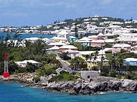 Residential suburb near the old St. George's Garrison, with "Town Cut Battery" or "Gate's Fort" on the shore of the Town Cut, and St. George's Town and its harbour in the background
 -
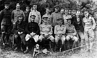 Officers of 3rd Battalion, The Royal Fusiliers (City of London Regiment), at Battalion Training at Tucker's Town, Bermuda, 1905. Bermuda's climate means heavier temperate uniforms were by armed forces and police personnel and are worn for much of the year.
 -
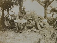 Battalion Training at Tucker's Town Bermuda of the 3rd Battalion Royal Fusiliers, wearing lightweight khaki drills, intended as a warm climate uniform, as a summer uniform.


,_at_Battalion_Training_at_Tucker%27s_Town,_Bermuda,_1905.jpg)

| Climate data for Bermuda (L.F. Wade International Airport) (1991-2020 normals, extremes 1949-2023)[b] | |||||||||||||
|---|---|---|---|---|---|---|---|---|---|---|---|---|---|
| Month | Jan | Feb | Mar | Apr | May | Jun | Jul | Aug | Sep | Oct | Nov | Dec | Year |
| Record high °C (°F) | 25.4 (77.7) |
26.1 (79.0) |
26.1 (79.0) |
27.2 (81.0) |
30.0 (86.0) |
32.2 (90.0) |
33.1 (91.6) |
33.9 (93.0) |
33.2 (91.8) |
31.7 (89.0) |
28.9 (84.0) |
26.7 (80.0) |
33.9 (93.0) |
| Mean maximum °C (°F) | 23.4 (74.1) |
23.1 (73.6) |
23.5 (74.3) |
24.4 (75.9) |
26.5 (79.7) |
29.1 (84.4) |
30.7 (87.3) |
31.2 (88.2) |
30.6 (87.1) |
28.9 (84.0) |
26.3 (79.3) |
24.5 (76.1) |
31.3 (88.3) |
| Mean daily maximum °C (°F) | 20.7 (69.3) |
20.4 (68.7) |
20.5 (68.9) |
22.1 (71.8) |
24.3 (75.7) |
27.2 (81.0) |
29.6 (85.3) |
30.1 (86.2) |
29.1 (84.4) |
26.7 (80.1) |
23.8 (74.8) |
21.8 (71.2) |
24.7 (76.5) |
| Daily mean °C (°F) | 18.3 (64.9) |
17.9 (64.2) |
18.1 (64.6) |
19.7 (67.5) |
Zdroj:https://en.wikipedia.org?pojem=Bermuda_Islands|||||||||