A | B | C | D | E | F | G | H | CH | I | J | K | L | M | N | O | P | Q | R | S | T | U | V | W | X | Y | Z | 0 | 1 | 2 | 3 | 4 | 5 | 6 | 7 | 8 | 9
This article needs additional citations for verification. (January 2024) |
Gyeonggi-do
경기도 | |
|---|---|
| Korean transcription(s) | |
| • Hangul | 경기도 |
| • Revised Romanization | Gyeonggi-do |
| • McCune‑Reischauer | Kyŏnggido |
 | |
| Coordinates: 37°30′N 127°15′E / 37.500°N 127.250°E | |
| Country | |
| Region | Seoul Capital |
| Capital | Suwon |
| Subdivisions | 28 cities; 3 counties |
| Government | |
| • Governor | Kim Dong-yeon (Democratic) |
| • Legislature | Gyeonggi Assembly |
| Area | |
| • Total | 10,184 km2 (3,932 sq mi) |
| • Rank | 5th |
| Population (Census 2020) | |
| • Total | 13,511,676 |
| • Rank | 1st |
| • Density | 1,327/km2 (3,440/sq mi) |
| Provincial symbols | |
| • Flower | Forsythia |
| • Tree | Ginkgo |
| • Bird | Dove |
| GDP | |
| • Total | KR₩ 547 trillion US$ 438 billion (2022) |
| ISO 3166 code | KR-41 |
| Dialect | Gyeonggi |
| Blog | Official blog |
| Website | Official website (English) |
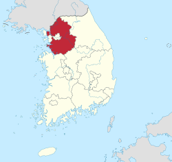
Gyeonggi-do (Korean: 경기도, Korean pronunciation: [kjʌ̹ŋ.ɡi.do̞]) is the most populous province in South Korea.
Seoul, the nation's largest city and capital, is in the heart of the area but has been separately administered as a provincial-level special city since 1946. Incheon, the nation's third-largest city, is on the coast of the province and has been similarly administered as a provincial-level metropolitan city since 1981. The three jurisdictions are collectively referred to as Sudogwon and cover 11,730 km2 (4,530 sq mi), with a combined population of over 26 million - amounting to over half (50.25%) of the entire population of South Korea at the 2020 Census.
Etymology
Its name, Gyeonggi, means "京 (the capital) and 畿 (the surrounding area)". Thus, Gyeonggi-do can be translated as "Seoul and the surrounding areas of Seoul".[citation needed]
History
Gyeonggi-do has been a politically important area since 18 BCE, when Korea was divided into three nations during the Three Kingdoms period. Ever since King Onjo, the founder of Baekje (one of the three kingdoms), founded the government in Wiryeseong of Hanam, the Han River Valley was absorbed into Goguryeo in the mid-fifth century, and became Silla's territory in the year 553 (the 14th year of King Jinheung).[nb 1] Afterward, the current location of Gyeonggi-do, one of the nine states of Later Silla, was called Hansanju.
The Gyeonggi region started to rise as the central region of Goryeo as King Taejo of Goryeo (the kingdom following Silla) set up the capital in Gaesong. Since 1018 (the 9th year of Goryeo's King Hyeonjong), this area has been officially called "Gyeonggi".

During the Joseon, which was founded after the Goryeo, King Taejo of Joseon set the capital in Hanyang, while restructuring Gyeonggi's area to include Gwangju, Suwon, Yeoju, and Anseong, along with the southeast region. Since the period of King Taejong and Sejong the Great, the Gyeonggi region has been very similar to the current administrative area of Gyeonggi-do.
In 1895 the 23-Bu system, which reorganized administrative areas, was effected. The Gyeonggi region was divided into Hanseong (modern Seoul), Incheon, Chungju, Gongju, and Kaesong.
During the Japanese colonial period, Hanseong-bu was incorporated into Gyeonggi-do. On October 1, 1910, it was renamed Keijo and a provincial government was placed in Keijo according to the reorganization of administrative districts.
After liberation and the foundation of two separate Korean states, Gyeonggi-do and its capital, Seoul, were separated with partial regions of Gyeonggi-do being incorporated into Seoul thereafter in 1946. Additionally, Kaesong became North Korean territory, the only city to change control after the countries were divided at the 38th parallel, which is now part of North Korea's North Hwanghae Province.
In 1967 the seat of the Gyeonggi provincial government was transferred from Seoul to Suwon. After Incheon separated from Gyeonggi-do in 1981, Gyeonggi regions such as Ongjin County and Ganghwa County were incorporated into Incheon in 1995.
Geography
Gyeonggi Province is in the western central region of the Korean Peninsula, which is vertically situated in Northeast Asia and is between east longitude of 126 and 127, and north latitude of 36 and 38. Its dimension is 10% of Korea's territory, 10,171 square kilometres (3,927 sq mi).[2] It is in contact with 86 kilometres (53 mi) of cease-fire line to the north, 413 kilometres (257 mi) of coastline to the west, Gangwon Province to the east, North Chungcheong Province and South Chungcheong Province to the south, and has Seoul, the capital of the Republic of Korea, in its center. Its provincial government is in Suwon, but some of its government buildings are in Uijeongbu for the administrative conveniences of the northern region.
Climate
The climate of Gyeonggi-do is the continental climate, which has a severe differentiation of temperature between summer and winter, and has distinctions of four seasons. Spring is warm, summer is hot and humid, autumn is cool, and winter is cold and snowy. The annual average temperature is between 11–13 °C (52–55 °F), where the temperature in the mountainous areas to the northeast is lower and the coastal areas to the southwest is higher. For January's average temperature, the Gyeonggi Bay is −4 °C (25 °F), the Namhangang (River) Basin is −4 to −6 °C (25 to 21 °F), and the Bukhangang (River) and Imjingang Basins are −6 to −8 °C (21 to 18 °F). It becomes colder and higher in temperature differentiation from coastal to inland areas. Summer has a lower local differentiation compared to winter. The inland areas are hotter than the Gyeonggi Bay area, the hottest area is Pyeongtaek, making the average temperature of August 26.5 °C (79.7 °F).
The annual average precipitation is around 1,100 millimetres (43 in), with a lot of rainfall. It is rainy in summer and dry during winter. The northeastern inland areas of Bukhangang and the upper stream of Imjingang has a precipitation of 1,300–1,400 millimetres (51–55 in), whereas the coastal area has only 900 millimetres (35 in) of precipitation.
Nature and national parks
The topography of Gyeonggi-do is divided into southern and northern areas by the Han River, which flows from east to west. The area north to the Han River is mainly mountainous, while the southern area is mainly plain.
The configuration of Gyeonggi-do is represented by Dong-go-seo-jeo (high in the east and low in the west), where the Gwangju Mountain Range and the Charyeong Mountain Range spreads from the east and drops in elevation in the west. The fields of Gimpo, Gyeonggi, and Pyeongtaek extend to the west.
Gyeonggi-do natural environment includes its rivers, lakes, mountains, and seas.[citation needed] Its representative rivers are the Hangang, Imjingang, and Anseongcheon Fg(Stream), which flow into the Yellow Sea, with Gyeonggi Plain, Yeonbaek Plain and Anseong Plain forming a fertile field area around the rivers. The Gwangju Mountain Range and the Charyeong Mountain Range stretch toward China in Gyeonggi Province. Most of the mountains that rise above 1,000 metres (3,300 ft), such as Myeongjisan (1,267 metres (4,157 ft)), Gukmangbong (1,168 metres (3,832 ft)) and Yongmunsan (1,157 metres (3,796 ft)) in the Gwangju Mountain Range. It iriidc Ktihas a developed granite area which, due to the granite's exfoliation effect, makes it full of strangely shaped cliffs and deep valleys. The Charyeong Mountain Range forms the boundary between Gyeonggi-do and Chungcheongbuk-do, but is a relatively low-altitude hilly area.
In Gyeonggi-do, there is Bukhansan National Park in Uijeongbu. For provincial parks, there are the Chukryeongsan Natural Recreation Area, Namhan-sanseong Provincial Park, Gapyeong Yeoninsan Provincial Park, and Mulhyanggi Arboretum. Besides the listed, the scenery of well-known mountains including Soyosan of Dongducheon City, Yongmunsan of Yangpyeong County, and Gwanaksan of Anyang and Gwacheon, along with Hangang and Imjingang are tourist sites of Gyeonggi-do.
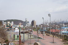
- Moraksan, a 385-meter rock mountain.
Population
| Year | Pop. | ±% p.a. | ||
|---|---|---|---|---|
| 1960 | 2,748,765 | — | ||
| 1980 | 3,703,761 | +1.50% | ||
| 1990 | 6,050,943 | +5.03% | ||
| 2000 | 8,984,134 | +4.03% | ||
| 2010 | 11,379,459 | +2.39% | ||
| 2015 | 12,479,061 | +1.86% | ||
| 2020 | 13,511,676 | +1.60% | ||
| ||||
| Source: Citypopulation[3] | ||||
Gyeonggi-do has shown a rapid increase in population due to the modernization and urbanization of the Republic of Korea. Its population has increased from 2,748,765 in 1960 to 3,703,761 in 1980; 6,050,943 in 1990; 8,984,134 in 2000; 11,379,459 in 2010; and 13,511,676 in 2020.
In 2010 there were 4,527,282 households, with an average of 3 people per family. There were 6,112,339 males and 5,959,545 females. The population density was 1,119 people/km2, almost double the national average of 486 people/km2.
Excluding the two metropolitan cities (Seoul and Incheon), the most heavily populated area as of 2010 is Suwon (1,104,681) followed by Goyang (1,076,179), Seongnam (996,524), Yongin (891,708), Bucheon (890,875) and Ansan (753,862). The lowest populated area in 2010 was Yeoncheon County (45,973), followed by Gapyeong County (59,916) and Yangpyeong County (72,595).
Economy
As the backbone of Seoul in the means of manufacturing complex, Gyeonggi-do is evenly developed in heavy industry (electronics, machine, heavy and chemical industry, steel), light industry (textile), and farm, livestock and fisheries industry. Due to the influence of recent high wages, the weight of manufacturing industries has decreased in Korea's economy. Gyeonggi-do is making efforts in many ways to improve and modernize the conventional industry structure, resulting in quick growth of innovative small and medium-sized enterprises such as U-JIN Tech Corp. Gyeonggi-do is unsparingly investing in the promotion of service industries related to soft competitive power such as state-of-the-art IT industry, designing, conventions and tourism, along with its great leap as a commercial hub in Northeast Asia using the Pyeongtaek Harbor.[4]
Besides this, it is known for its special local products such as Icheon rice and Icheon/Gwangju ceramics. Leading companies representing Korea, including Samsung Electronics' headquarters, SK Hynix's headquarters, NAVER's headquarters, Samsung SDI's headquarters, and Paju LG Corporation's LCD complex, are gathered in southern Gyeonggi Province, including Suwon City.[5]
Administrative area


Gyeonggi-do consists of 28 cities (special: 7, normal: 21) and three counties.[6] This is because many counties were elevated to city status owing to the influence of Seoul's new town development plan. Special cities are especially concentrated in the southern area of Gyeonggi-do.
Listed below is each entity's name in English, Hangul and Hanja.


