A | B | C | D | E | F | G | H | CH | I | J | K | L | M | N | O | P | Q | R | S | T | U | V | W | X | Y | Z | 0 | 1 | 2 | 3 | 4 | 5 | 6 | 7 | 8 | 9
Curaçao Kòrsou (Papiamentu) | |
|---|---|
| Country of Curaçao Land Curaçao (Dutch) Pais Kòrsou (Papiamentu) | |
| Anthem: "Himno di Kòrsou" (English: "Anthem of Curaçao") | |
| Royal anthem: "Wilhelmus" (English: "William of Nassau") | |
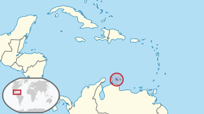
 Location of Curaçao (circled in red) | |
| Sovereign state | |
| Country status | 10 October 2010 |
| Capital and largest city | Willemstad 12°7′N 68°56′W / 12.117°N 68.933°W |
| Official languages | |
| Ethnic groups (2018) | 75.4% Curaçaoans 9% Dutch 3.6% Dominican 3% Colombian 1.2% Haitian 1.2% Surinamese 1.1% Venezuelan 1.1% Aruban 0.9% unspecified 6% other[1] |
| Religion |
|
| Demonym(s) | Curaçaoan |
| Government | Parliamentary representative democracy within a constitutional monarchy |
• Monarch | Willem-Alexander |
• Governor | Lucille George-Wout |
• Speaker | Charetti America-Francisca |
| Gilmar Pisas | |
| Legislature | Parliament of Curaçao |
| Area | |
• Total | 444[2] km2 (171 sq mi) (181th) |
| Highest elevation | 372 m (1,220 ft) |
| Population | |
• 2023 estimate | 148,925[3] (177th) |
• Density | 349.13/km2 (904.2/sq mi) |
| GDP (PPP) | 2021[4] estimate |
• Total | $5.5 billion (184th) |
• Per capita | $35,484 (45th) |
| GDP (nominal) | 2021 estimate |
• Total | $3.5 billion[5] (149th) |
• Per capita | $22,581 (40th) |
| HDI (2012) | 0.811[6] very high |
| Currency | Netherlands Antillean guilder (ƒ) |
| Time zone | UTC−4:00 (AST) |
| Driving side | right |
| Calling code | +599 |
| ISO 3166 code | |
| Internet TLD | .cw |
Curaçao (/ˈkjʊərəsoʊ, -saʊ, ˌkjʊərəˈsoʊ, -ˈsaʊ/ KURE-ə-soh, KURE-ə-sow, kure-ə-SOH, or kure-ə-SOW,[7][8] Dutch: [kyːraːˈsʌu] or [kuːr-],[9] Papiamentu: [ˈkɔrsɔu̯]), officially the Country of Curaçao (Dutch: Land Curaçao;[10] Papiamentu: Pais Kòrsou),[11][12] is a Lesser Antilles island in the southern Caribbean Sea, specifically the Dutch Caribbean region, about 65 km (40 mi) north of Venezuela. It is a constituent country of the Kingdom of the Netherlands.[13]
Curaçao includes the main island of Curaçao and much smaller, uninhabited island of Klein Curaçao ("Little Curaçao").[12] Curaçao has a population of 158,665 (January 2019 est.),[2] with an area of 444 km2 (171 sq mi); its capital is Willemstad.[12] Together with Aruba and Bonaire, Curaçao forms the ABC islands. Collectively, Curaçao, Aruba, and other Dutch islands in the Caribbean are often called the Dutch Caribbean. It is the largest of the ABC islands in area and population, and the largest of the Dutch Caribbean.[14]
The name "Curaçao" may originate from the indigenous autonym of its people; this idea is supported by early Spanish accounts referring to the inhabitants as Indios Curaçaos. Curaçao's history begins with the Arawak and Caquetio Amerindians; the island becoming a Spanish colony after Alonso de Ojeda's 1499 expedition. Though labelled "the useless island" due to its poor agricultural yield and lack of precious metals, it became a strategic cattle ranching area. When the Dutch colonized the island in 1634, they shifted the island's focus to trade and shipping, and later made it a hub of the Atlantic slave trade. Members of the Jewish community, fleeing persecution in Europe, settled here and significantly influenced the economy and culture.
The 18th and 19th centuries saw Curaçao under attack by the British but it remained predominantly Dutch. The abolition of slavery in 1863 led to economic shifts and migrations. Dutch remains the official language, though Papiamentu, English, and Spanish are widely spoken, reflecting the island's diverse cultural influences. Curaçao was formerly part of the Curaçao and Dependencies colony from 1815 to 1954 and later the Netherlands Antilles from 1954 to 2010, as Island Territory of Curaçao.[15][16][12]
The discovery of oil in the Maracaibo Basin in 1914 transformed Curaçao into a critical refinery location, altering its economic landscape. There were efforts towards becoming a country within the Kingdom of the Netherlands; the island achieved autonomy in 2010. Despite facing challenges, including economic stagnation and COVID, Curaçao continues to navigate its path within the Caribbean and the world stage.
Etymology
One explanation for the island's name is that Curaçao was the autonym by which its indigenous peoples identified themselves.[17] Early Spanish accounts support this theory, referring to the indigenous peoples as Indios Curaçaos.[18]
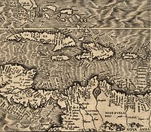
From 1525, the island was featured on Spanish maps as Curaçote, Curasaote, Curasaore, and even Curacaute.[19] By the 17th century, it appeared on most maps as Curaçao or Curazao.[18] On a map created by Hieronymus Cock in 1562 in Antwerp, the island was called Qúracao.[20]
A persistent but undocumented story claims the following: in the 16th and 17th centuries—the early years of European exploration—when sailors on long voyages got scurvy from lack of vitamin C, sick Portuguese or Spanish sailors were left on the island now known as Curaçao. When their ship returned, some had recovered, probably after eating vitamin C-rich fruit there. From then on, the Portuguese allegedly referred to the island as Ilha da Curação (Island of Healing) or the Spanish as Isla de la Curación.[12]
History
Pre-colonial


The original inhabitants of Curaçao were the Arawak and Caquetio Amerindians.[21] Their ancestors had migrated to the island from the mainland of South America, probably hundreds of years before Europeans' first arrival.
Spanish colonization
The first Europeans recorded as seeing the island were members of a Spanish expedition under the leadership of Alonso de Ojeda in 1499.[21] The Spaniards enslaved most of the Caquetios (Arawak) for forced labour in their Hispaniola colony, but paid little attention to the island itself.[21] In 1515, almost all of the 2,000 Caquetios living there were also transported to Hispaniola as slaves.
Established in 1499 as a Spanish launchpad for exploring northern South America, Curaçao was officially settled by Spain in 1527. It functioned as an island extension of Venezuela throughout the 1500s. As mainland colonization advanced, Spain slowly withdrew from the island. The city registry of Caracas, Venezuela holds one of the earliest written mentions of Curaçao. A document dated 9 December 1595 states that Francisco Montesinos, priest and vicar of "the Yslas de Curasao, Aruba and Bonaire" conferred his power of attorney to Pedro Gutiérrez de Lugo, a Caracas resident, to collect his ecclesiastic salary from the Royal Treasury of King Philip II of Spain.
The Spanish introduced numerous tree, plant and animal species to Curaçao, including horses, sheep, goats, pigs and cattle from Europe and other Spanish colonies. In general, imported sheep, goats and cattle did relatively well. Cattle were herded by Caquetios and Spaniards and roamed freely in the kunuku plantations and savannas.
Not all imported species fared equally well, and the Spanish also learned to use Caquetio crops and agricultural methods, as well as those from other Caribbean islands. Though historical sources point to thousands of people living on the island, agricultural yields were disappointing; this and the lack of precious metals in the salt mines led the Spanish to call Curaçao "the useless island".
Over time, the number of Spaniards living on Curaçao decreased while the number of aboriginal inhabitants stabilized. Presumably through natural growth, return and colonization, the Caquetio population then began to increase. In the last decades of Spanish occupation, Curaçao was used as a large cattle ranch. At that point, Spaniards lived around Santa Barbara, Santa Ana and in the villages in the western part of the island, while the Caquetios are thought to have lived scattered all over the island.
Dutch colonial rule
In 1634, during the Eighty Years' War of independence between the Republic of the Netherlands and Spain, the Dutch West India Company under Admiral Johann van Walbeeck invaded the island; the Spanish surrendered in San Juan in August. Approximately 30 Spaniards and many indigenous people were then deported to Santa Ana de Coro in Venezuela. About 30 Taíno families were allowed to live on the island while Dutch colonists started settling there.[21]
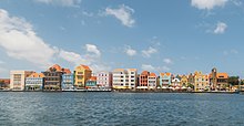
The Dutch West India Company founded the capital of Willemstad on the banks of an inlet called the Schottegat; the natural harbour proved an ideal place for trade. Commerce and shipping—and piracy—became Curaçao's most important economic activities. Later, salt mining became a major industry, the mineral being a lucrative export at the time.[citation needed] From 1662, the Dutch West India Company made Curaçao a centre of the Atlantic slave trade, often bringing slaves from West Africa to the island, before selling them elsewhere in the Caribbean and Spanish Main.[21]
Sephardic Jews fleeing persecution in Spain and Portugal sought safe haven in Dutch Brazil and the Dutch Republic. Many settled in Curaçao, where they made significant contributions to its civil society, cultural development and economic prosperity.[22] In 1674 the island became a free port.[23]
In the Franco-Dutch War of 1672–78, French Count Jean II d'Estrées planned to attack Curaçao. His fleet—12 men-of-war, three fire ships, two transports, a hospital ship, and 12 privateers—met with disaster, losing seven men-of-war and two other ships when they struck reefs off the Las Aves archipelago. The serious navigational error occurred on 11 May 1678, a week after the fleet set sail from Saint Kitts. To commemorate its narrow escape from invasion, Curaçao marked the events with a day of thanksgiving, which was celebrated for decades into the 18th century.[citation needed]

Many Dutch colonists grew affluent from the slave trade, building impressive colonial buildings in the capital of Willemstad; the city is now a UNESCO World Heritage Site.
In 1795, a major slave revolt took place under the leaders Tula Rigaud, Louis Mercier, Bastian Karpata, and Pedro Wakao. Up to 4,000 slaves in northwest Curaçao revolted, with more than 1,000 taking part in extended gunfights. After a month, the slave owners were able to suppress the revolt.[24][25]


Curaçao's proximity to South America resulted in interaction with cultures of the coastal areas more than a century after the independence of the Netherlands from Spain. Architectural similarities can be seen between 19th century Willemstad neighborhoods and the nearby Venezuelan city of Coro in Falcón State, which has also been designated a World Heritage Site. Netherlands established economic ties with the Viceroyalty of New Granada that included the present-day countries of Colombia and Venezuela. In the 19th century, Curaçaoans such as Manuel Piar and Luis Brión were prominently engaged in the wars of independence of both Venezuela and Colombia. Political refugees from the mainland, such as Simon Bolivar, regrouped in Curaçao.[26]
During the 18th and 19th centuries, the British attacked the island several times, most notably in 1800, 1804, and from 1807 to 1815.[27] Stable Dutch rule returned in 1815 at the end of the Napoleonic wars, when the island was incorporated into the colony of Curaçao and Dependencies.[28]
The Dutch abolished slavery in 1863, causing vast changes in the economy with the shift to wage labour.[28] Some Curaçao inhabitants emigrated to other islands, such as Cuba, to work in sugarcane plantations. Other former slaves had nowhere to go and continued working for plantation owners under the tenant farmer system,[29] in which former slaves leased land from former masters, paying most of their harvest to owners as rent. The system lasted until the early 20th century.[citation needed]
Historically, Dutch was not widely spoken on the island outside of the colonial administration, but its use increased in the late 19th and early 20th centuries.[30] Students on Curaçao, Aruba, and Bonaire were taught predominantly in Spanish until the late 17th century, when the British took all three islands. Teaching of Spanish was restored when Dutch rule resumed in 1815. Also, efforts were made to introduce widespread bilingual Dutch and Papiamentu education in the late 19th century.[31]
20th and 21st centuries
When oil was discovered in the Venezuelan Maracaibo Basin town of Mene Grande in 1914, Curaçao's economy was dramatically altered. In the early years, both Shell and Exxon held drilling concessions in Venezuela, which ensured a constant supply of crude oil to refineries in Aruba and Curaçao. Crude oil production in Venezuela was inexpensive. Both Shell and Exxon were vertically integrated and controlled the entire industry, from pumping, transporting, and refining to sales. The refineries on Aruba and Curaçao operated in global markets and were profitable partly because of the margin between the production costs of crude oil and the revenues made off of products. This provided a safety net for losses incurred through inefficiency or excessive operating costs at the refineries.[21][unreliable source?]
In 1929, Curaçao was attacked by Venezuelan rebel commander Rafael Simón Urbina, who, with 250 soldiers, captured the fort. The Venezuelans plundered weapons, ammunition, and the island's treasury. They also managed to capture the Governor of the island, Leonardus Albertus Fruytier (1882–1972), and hauled him off to Venezuela on a stolen American ship, Maracaibo. Fruytier was criticized and had to resign as governor. After returning to the Netherlands, he settled for a position as chief inspector in Maastricht. The Dutch increased their military presence on the island.[32][33]
In 1936 burning bale of cotton thrown overboard by the crew of the M. S. Colombia, which lay anchored in the Schottegat, caused the oil floating on the water to catch fire. It took days to get the fire under control; houses had to be evacuated, but there were no casualties.
In 1954, Curaçao and other Dutch Caribbean colonies were joined to form the Netherlands Antilles. Discontent with Curaçao's seemingly subordinate relationship to the Netherlands, ongoing racial discrimination, and a rise in unemployment owing to layoffs in the oil industry led to a series of riots in 1969.[34] The riots resulted in two deaths, numerous injuries and severe damage in Willemstad. In response, the Dutch government introduced far-reaching reforms, allowing Afro-Curaçaoans greater influence over the island's political and economic life, and increased the prominence of the local Papiamentu language.[35]

Curaçao experienced an economic downturn in the early 1980s. Shell's refinery on the island operated with significant losses from 1975 to 1979, and again from 1982 to 1985. Persistent losses, global overproduction, stronger competition, and low market expectations threatened the refinery's future. In 1985, after 70 years, Royal Dutch Shell decided to end its activities on Curaçao. This came at a crucial moment. Curaçao's fragile economy had been stagnant for some time. Several revenue-generating sectors suffered even more during this period: tourism from Venezuela collapsed after the devaluation of the bolivar, and a slowdown in the transportation sector had deleterious effects on the Antillean Airline Company and the Curaçao Dry Dock Company. The offshore financial services industry also experienced a downturn due to new U.S. tax laws.[citation needed]
In the mid-1980s, Shell sold its refinery for the symbolic amount of one Antillean guilder to a local government consortium. In recent years, the aging refinery has been the subject of lawsuits alleging that its emissions, including sulfur dioxide and particulate matter, far exceed safety standards.[36] The government consortium leases the refinery to the Venezuelan PDVSA state oil company.[36]
Continuing economic hardship in the late 1990s and early 2000s resulted in much emigration to the Netherlands.[37]
On 1 July 2007, Curaçao was due to become a country within the Kingdom of the Netherlands, like Aruba and the Netherlands Antilles. On 28 November 2006, the change was delayed when the island council rejected a clarification memorandum on the process. A new island council ratified this agreement on 9 July 2007.[38] On 15 December 2008, Curaçao was again scheduled to become a separate country within the Kingdom of the Netherlands. A non-binding referendum on the move was held in Curaçao on 15 May 2009; 52% of voters supported it.[39]
Since the dissolution of the Netherlands Antilles
The dissolution of the Netherlands Antilles came into effect on 10 October 2010.[40][41] Curaçao became a country within the Kingdom of the Netherlands, with the kingdom retaining responsibility for defence and foreign policy. The kingdom was also tasked with overseeing the island's finances under a debt-relief arrangement agreed upon between the two.[42] Curaçao's first prime minister was Gerrit Schotte. He was succeeded in 2012 by Stanley Betrian, ad interim. After the 2012 elections, Daniel Hodge became the third prime minister on 31 December 2012.[43] He led a demissionary cabinet until 7 June 2013, when a new cabinet under the leadership of Ivar Asjes was sworn in.[44]
Although Curaçao is autonomous, the Netherlands has intervened in its affairs to ensure that parliamentary elections are held and to assist in finalizing accurate budgets. In July 2017, Curaçaoan Prime Minister Eugene Rhuggenaath said he wanted Curaçao to take full responsibility over its affairs, but asked for more cooperation and assistance from the Netherlands, with suggestions for more innovative approaches to help Curaçao succeed and increase its standard of living.[45][46] The Dutch government reminded the Curaçaoan government that it had provided assistance with oil refinery negotiations with the Chinese "on numerous occasions".[47]
The 2020 COVID-19 pandemic resulted in austerity measures. Curaçao had to impose spending cuts to qualify for additional aid from the Netherlands.[48] As part of the austerity package, the Government of Curaçao announced a 12.5% cut in benefits for civil servants.[49] On 24 June 2020, a group of civil servants, together with waste collectors from Selikor, marched to Fort Amsterdam and demanded to speak with Rhuggenaath.[49] The demonstration turned into a riot, and police cleared the square in front of Fort Amsterdam[50] with tear gas.[51] The city centre of Willemstad was later looted.[50] 48 people were arrested,[52] the city districts of Punda and Otrobanda were placed under lockdown for the night, and a general curfew was declared from 20:30 to 06:00.[53]
Geography


Curaçao, as well as the rest of the ABC islands and Trinidad and Tobago, lies on the continental shelf of South America. It is a thin island with a generally hilly topography; the highest point is Christoffelberg in the northwest, with a peak at 372 m (1,220 ft) above sea level.[54] The coastline's bays, inlets and hot springs offer a source of natural minerals, thermal conditions, and seawater used in hydrotherapy and mesotherapy, making the island one of many balneoclimateric areas in the region. Off the southeast coast lies the small, flat island of Klein Curaçao.[12]
Flora
Curaçao's flora differ from typical tropical island vegetation. Guajira-Barranquilla xeric scrub is the most notable, with various forms of cacti, thorny shrubs, evergreen, and watapana trees (Libidibia coriaria; called divi-divi on Aruba), which are characteristic of the ABC islands and the national symbol of Aruba. Brassavola nodosa is a drought-tolerant species of Brassavola, one of the few orchids present in the ABC islands. Cacti include Melocactus and Opuntia species such as Opuntia stricta.[citation needed]

Fauna
Curaçao is semi-arid, and as such has not supported the numerous tropical species of mammals, birds, and lizards most associated with rainforests. Dozens of species of hummingbirds, bananaquits, orioles, and the larger terns, herons, egrets, and even flamingos make their homes near ponds or in coastal areas. The trupial, a black bird with a bright orange underbelly and white swatches on its wings, is common to Curaçao. The mockingbird, called chuchubi in Papiamentu, resembles the North American mockingbird, with a long white-grey tail and a grey back. Near shorelines, big-billed brown pelicans feed on fish. Other seabirds include several types of gulls and large cormorants.[55]
Other than field mice, small rabbits, and cave bats, Curaçao's most notable animal is the white-tailed deer. This deer is related to the American white-tailed deer, or Virginia deer, found in areas from North America through Central America and the Caribbean, and as far south as Bolivia. It can be a large deer, some reaching six feet (2 m) in length and three feet (0.9 m) in height, and weighing as much as 300 pounds (140 kg). It has a long tail with a white underside, and is the only type of deer on the island. It has been a protected species since 1926, and an estimated 200 live on Curaçao. They are found in many parts of the island, but most notably at the west end's Christoffel Park, where about 70% of the herd resides. Archaeologists believe the deer were brought from South America to Curaçao by its original inhabitants, the Arawaks.[citation needed]
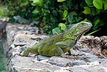
There are several species of iguana, light green in colour with shimmering shades of aqua along the belly and sides, found lounging in the sun across the island. The iguanas found on Curaçao serve not only as a scenic attraction but, unlike many islands that gave up the practice years ago, remain hunted for food. Along the west end of the island's north shore are several inlets that have become home to breeding sea turtles. These turtles are protected by the park system in Shete Boka Park, and can be visited accompanied by park rangers.[citation needed]
Climate
Curaçao has a hot, semi-arid climate (Köppen climate classification BSh) with a dry season from January to September and a wet season from October to December.[56] Rainfall is scarce, only 450 millimeters (12 inches) per year; in particular, the rainy season is drier than it normally is in tropical climates; during the dry season, it almost never rains. Owing to the scarcity of rainfall, the landscape of Curaçao is arid; especially on the north coast of the island. Temperatures are relatively constant, with small differences measured throughout the year. The trade winds cool the island during the day and warm it at night. The coolest month is January with an average temperature of 26.6 °C or 80 °F; the hottest is September with an average temperature of 29.1 °C or 84 °F. The year's average maximum temperature is 31.4 °C or 89 °F. The year's average temperature is 25.7 °C or 78 °F. The seawater around Curaçao averages around 27 °C (81 °F) and is coolest (avg. 25.9 °C ) from February to March, and hottest (avg. 28.2 °C ) from September to October.[citation needed]
Because Curaçao lies North of the Intertropical Convergence Zone and in an area of low-level divergence where winds flow parallel to the coast, its climate is much drier than expected for the northeastern side of a continent at its latitude. Rainfall is also extremely variable from year to year,[57] being strongly linked to the El Niño Southern Oscillation. As little as 200 millimetres or 8 inches may fall in a strong El Niño year, but as much as 1,150 millimetres or 45 inches is not unknown in powerful La Niña years.
Curaçao lies outside the Main Development Region for tropical cyclones, but is still occasionally affected by them, as with Hurricanes Hazel in 1954, Anna in 1961, Felix in 2007, and Omar in 2008. No hurricane has made landfall in Curaçao since the US National Hurricane Center started tracking hurricanes. Curaçao has, however, been directly affected by pre-hurricane tropical storms several times; the latest being Hurricane Tomas in 2010, Cesar in 1996, Joan in 1988, Cora and Greta in 1978, Edith and Irene in 1971, and Francelia in 1969. Tomas brushed past Curaçao as a tropical storm, dropping as much as 265 mm (10.4 in) of rain on the island, nearly half its annual precipitation in a single day.[58] This made Tomas one of the wettest events in the island's history,[59] as well as one of the most devastating; its flooding killed two people and caused over NAƒ50 million (US$28 million) in damage.[60][61]
According to the Emissions Database for Global Atmospheric Research, average carbon dioxide emissions per person on the island were 52 tonnes in 2018, the second highest in the world.[62]
Meteo, the Curaçao weather department, provides up-to-date information about weather conditions via its website and mobile apps for iOS and Android.[63]


