

A | B | C | D | E | F | G | H | CH | I | J | K | L | M | N | O | P | Q | R | S | T | U | V | W | X | Y | Z | 0 | 1 | 2 | 3 | 4 | 5 | 6 | 7 | 8 | 9
Kathmandu
काठमाडौँ Kasthamandaw, Kantipur, Yen | |
|---|---|
| Kathmandu Metropolitan City | |
Kathmandu's skyline with Gaurishankar visible | |
 Flag Seal | |
| Nickname: | |
| Motto(s): | |
 Kathmandu  Kathmandu  Kathmandu | |
| Coordinates: 27°43′N 85°19′E / 27.71°N 85.32°E | |
| Country | |
| Province | Bagmati |
| District | Kathmandu |
| Founded by | Manjushri |
| Named for | Kasthamandap |
| No. of Wards | 32 |
| Government | |
| • Type | Mayor–council government |
| • Body | Kathmandu Metropolitan Government |
| • Mayor | Balen Shah (Ind.) |
| • Deputy mayor | Sunita Dangol (UML) |
| • Executive Officer | Pradeep Pariyar[3] |
| Area | |
| • Capital city | 49.45 km2 (19.09 sq mi) |
| • Metro | 899 km2 (347 sq mi) |
| Elevation | 1,400 m (4,600 ft) |
| Population | |
| • Capital city | 856,767 |
| • Rank | 1st |
| • Density | 17,103/km2 (44,300/sq mi) |
| • Metro | Approximately 4 million |
| • Metro rank | 1st |
| Time zone | UTC+05:45 (Nepal Standard Time) |
| Postal Code | 44600 |
| Area code | 01 |
| Website | www |
.jpg)


Kathmandu,[a] officially Kathmandu Metropolitan City,[b] is the capital and most populous city of Nepal with 845,767 inhabitants living in 105,649 households as of the 2021 Nepal census[4] and approximately 4 million people in its urban agglomeration. It is located in the Kathmandu Valley, a large valley in the high plateaus in central Nepal, at an altitude of 1,400 metres (4,600 feet).
The city is one of the oldest continuously inhabited places in the world, founded in the 2nd century AD. The valley was historically called the "Nepal Mandala" and has been the home of the Newar people, a cosmopolitan urban civilization in the Himalayan foothills. The city was the royal capital of the Kingdom of Nepal and hosts palaces, mansions and gardens built by the Nepali aristocracy. It has been home to the headquarters of the South Asian Association for Regional Cooperation (SAARC) since 1985. Today, it is the seat of government of the Federal Democratic Republic of Nepal, established in 2008, and is part of Bagmati Province.
Kathmandu is and has been for many years the centre of Nepal's history, art, culture, and economy. It has a multi-ethnic population within a Hindu and Buddhist majority. Religious and cultural festivities form a major part of the lives of people residing in Kathmandu. Tourism is an important part of the economy in the city. In 2013, Kathmandu was ranked third among the top ten upcoming travel destinations in the world by TripAdvisor, and ranked first in Asia. The city is considered the gateway to the Nepal Himalayas and is home to several World Heritage Sites: the Durbar Square, Swayambhu Mahachaitya, Bouddha and Pashupatinath. Kathmandu valley is growing at 4 per cent per year according to the World Bank in 2010, making it one of the fastest-growing metropolitan areas in South Asia, and the first region in Nepal to face the unprecedented challenges of rapid urbanization and modernization at a metropolitan scale.[6] It is the largest metropolitan area located in the Himalayas.
Etymology
The indigenous Nepal Bhasa term for Kathmandu is Yen. The Nepali name Kathmandu comes from Kasthamandap, a building which stood in Kathmandu Durbar Square, was completely destroyed by the April 2015 Nepal Earthquake, but has since been reconstructed. In Sanskrit, Kāṣṭha (Sanskrit: काष्ठ) means "wood" and Maṇḍapa (Sanskrit: मण्डप) means "pavilion". This public pavilion, also known as Maru Satta in Newari, was rebuilt in 1596 by Biseth in the period of King Laxmi Narsingh Malla. The three-storey structure was made entirely of wood and used no iron nails nor supports. According to legends, all the timber used to build the pagoda was obtained from a single tree.[7]
The colophons of ancient manuscripts, dated as late as the 20th century, refer to Kathmandu as Kāṣṭhamaṇḍap Mahānagar in Nepal Mandala. Mahānagar means "great city". The city is called Kāṣṭhamaṇḍap in a vow that Buddhist priests still recite to this day. Thus, Kathmandu is also known as Kāṣṭhamaṇḍap. During medieval times, the city was sometimes called Kāntipur (Sanskrit: कान्तिपुर). This name is derived from two Sanskrit words – Kānti and Pur. Kānti is a word that stands for "beauty" and is mostly associated with light and Pur means place, thus giving it the meaning, "City of light".
Among the indigenous Newar people, Kathmandu is known as Yeṃ Dey (Newar: येँ देय्), and Patan and Bhaktapur are known as Yala Dey (Newar: यल देय्) and Khwopa Dey (Newar: ख्वप देय्) respectively.[8] "Yen" is the shorter form of Yambu (Newar: यम्बु), which originally referred to the northern half of Kathmandu. The older northern settlements were referred to as Yambi while the southern settlement was known as Yangala.[9][10]
The spelling "Katmandu" was often used in older English-language text. More recently, however, the spelling "Kathmandu" has become more common in English.[11]
History

Archaeological excavations in parts of Kathmandu have found evidence of ancient civilizations. The oldest of these findings is a statue, found in Maligaon, that was dated at 185 AD.[12] The excavation of Dhando Chaitya uncovered a brick with an inscription in Brahmi script. Archaeologists believe that it is two thousand years old.[12] Stone inscriptions are ubiquitous elements at the heritage sites and are key sources for the history of Nepal.
The earliest Western reference to Kathmandu appears in an account of Portuguese Jesuit Father Joao Cabral who passed through the Kathmandu Valley in the spring of 1628[13] and was received graciously by the king of that time, probably King Lakshminarasimha Malla of Kathmandu on their way from Tibet to India.[14] Father Cabral reported that they reached "Cadmendu", the capital of Nepal kingdom.[15]
Ancient history
The ancient history of Kathmandu is described in its traditional myths and legends. According to the Swayambhu Purana, present-day Kathmandu was once a huge and deep lake named "Nagdaha", as it was full of snakes. The lake was cut drained by Bodhisattva Manjushri with his sword, and the water was evacuated out from there. He then established a city called Manjupattan, and made Dharmakar the ruler of the valley land. After some time, a demon named Banasura closed the outlet, and the valley again turned into a lake. Krishna came to Nepal, killed Banasura, and again drained out the water by cutting the edge of Chobhar hill with this Sudarshana Chakra. He brought some cowherds along with him and made Bhuktaman the king of Nepal.[16][17][18]
Kotirudra Samhita of Shiva Purana, Chapter 11, Shloka 18 refers to the place as Nayapala city, which was famous for its Pashupati Shivalinga. The name Nepal probably originates from this city Nayapala.
Very few historical records exists of the period before medieval Licchavi rulers. According to Gopalraj Vansawali, a genealogy of Nepali monarchy, the rulers of Kathmandu Valley before the Licchavis were Gopalas, Mahispalas, Aabhirs, Kiratas, and Somavanshi.[18][19] The Kirata dynasty was established by Yalamber. During the Kirata era, a settlement called Yambu existed in the northern half of old Kathmandu. In some of the Sino-Tibetan languages, Kathmandu is still called Yambu. Another smaller settlement called Yengal was present in the southern half of old Kathmandu, near Manjupattan. During the reign of the seventh Kirata ruler, Jitedasti, Buddhist monks entered Kathmandu valley and established a forest monastery at Sankhu.

Licchavi era
The Licchavis from Vaisali in modern-day Bihar, migrated north and defeated the Kirats, establishing the Licchavi dynasty, circa 400 AD. During this era, following the genocide of Shakyas in Lumbini by Virudhaka, the survivors migrated north and entered the forest monastery lora masquerading as Koliyas. From Sankhu, they migrated to Yambu and Yengal (Lanjagwal and Manjupattan) and established the first permanent Buddhist monasteries of Kathmandu. This created the basis of Newar Buddhism, which is the only surviving Sanskrit-based Buddhist tradition in the world.[21] With their migration, Yambu was called Koligram and Yengal was called Dakshin Koligram[22] during most of the Licchavi era.[23]
Eventually, the Licchavi ruler Gunakamadeva merged Koligram and Dakshin Koligram, founding the city of Kathmandu.[23] The city was designed in the shape of Chandrahrasa, the sword of Manjushri. The city was surrounded by eight barracks guarded by Ajimas. One of these barracks is still in use at Bhadrakali (in front of Singha Durbar). The city served as an important transit point in the trade between India and Tibet, leading to tremendous growth in architecture. Descriptions of buildings such as Managriha, Kailaskut Bhawan, and Bhadradiwas Bhawan have been found in the surviving journals of travellers and monks who lived during this era. For example, the famous 7th-century Chinese traveller Xuanzang described Kailaskut Bhawan, the palace of the Licchavi king Amshuverma.[24] The trade route also led to cultural exchange as well. The artistry of the Newar people—the indigenous inhabitants of the Kathmandu Valley—became highly sought after during this era, both within the Valley and throughout the greater Himalayas. Newar artists travelled extensively throughout Asia, creating religious art for their neighbours. For example, Araniko led a group of his compatriot artists through Tibet and China. Bhrikuti, the princess of Nepal who married Tibetan monarch Songtsän Gampo, was instrumental in introducing Buddhism to Tibet.
Malla era
.jpg)


The Licchavi era was followed by the Malla era. Rulers from Tirhut, upon being attacked by the Delhi Sultanate, fled north to the Kathmandu valley. They intermarried with Nepali royalty, and this led to the Malla era. The early years of the Malla era were turbulent, with raids and attacks from Khas and Turk Muslims. There was also a devastating earthquake which claimed the lives of a third of Kathmandu's population, including the king Abhaya Malla. These disasters led to the destruction of most of the architecture of the Licchavi era (such as Mangriha and Kailashkut Bhawan), and the loss of literature collected in various monasteries within the city. Despite the initial hardships, Kathmandu rose to prominence again and, during most of the Malla era, dominated the trade between India and Tibet. Nepali currency became the standard currency in trans-Himalayan trade.
During the later part of the Malla era, Kathmandu Valley comprised four fortified cities: Kantipur, Lalitpur, Bhaktapur, and Kirtipur. These served as the capitals of the Malla confederation of Nepal. These states competed with each other in the arts, architecture, esthetics, and trade, resulting in tremendous development. The kings of this period directly influenced or involved themselves in the construction of public buildings, squares, and temples, as well as the development of waterspouts, the institutionalisation of trusts (called guthis), the codification of laws, the writing of dramas, and the performance of plays in city squares. Evidence of an influx of ideas from India, Tibet, China, Persia, and Europe among other places can be found in a stone inscription from the time of king Pratap Malla. Books have been found from this era that describe their tantric tradition (e.g. Tantrakhyan), medicine (e.g. Haramekhala), religion (e.g. Mooldevshashidev), law, morals, and history. Amarkosh, a Sanskrit-Nepal Bhasa dictionary from 1381, was also found. Architecturally notable buildings from this era include Kathmandu Durbar Square, Patan Durbar Square, Bhaktapur Durbar Square, the former durbar of Kirtipur, Nyatapola, Kumbheshwar, the Krishna temple, and others.
Medieval era

Early Shah rule
The Gorkha Kingdom ended the Malla confederation after the Battle of Kathmandu in 1768. This marked the beginning of the modern era in Kathmandu. The Battle of Kirtipur was the start of the Gorkha conquest of the Kathmandu Valley. Kathmandu was adopted as the capital of the Gorkha empire, and the empire itself was dubbed Nepal. During the early part of this era, Kathmandu maintained its distinctive culture. Buildings with characteristic Nepali architecture, such as the nine-story tower of Basantapur, were built during this era. However, trade declined because of continual war with neighbouring nations. Bhimsen Thapa supported France against Great Britain; this led to the development of modern military structures, such as modern barracks in Kathmandu. The nine-storey tower Dharahara was originally built during this era.
Rana rule
Rana rule over Nepal started with the Kot massacre of 1846, which occurred near Hanuman Dhoka Durbar. During this massacre, most of Nepal's high-ranking officials were massacred by Jung Bahadur Rana and his supporters. Another massacre, the Bhandarkhal Massacre, was also conducted by Kunwar and his supporters in Kathmandu. During the Rana regime, Kathmandu's alliance shifted from anti-British to pro-British; this led to the construction of the first buildings in the style of Western European architecture. The most well-known of these buildings include Singha Durbar, Garden of Dreams, Shital Niwas, and the old Narayanhiti palace. The first modern commercial road in the Kathmandu Valley, the New Road, was also built during this era. Trichandra College (the first college of Nepal), Durbar High School (the first modern school of Nepal), and Bir Hospital (the first hospital of Nepal) were built in Kathmandu during this era. Education was only accessible to the privileged class. Rana rule was marked by despotism, economic exploitation and religious persecution.[25][26]
Geography
Kathmandu is in the northwestern part of the Kathmandu Valley to the north of the Bagmati River and covers an area of 50.7 km2 (19.6 sq mi). The average elevation is 1,400 metres (4,600 ft) above sea level.[27] The city is bounded by several other municipalities of the Kathmandu valley: south of the Bagmati by Lalitpur Metropolitan City (Patan), with which it forms one urban area surrounded by a ring road, to the southwest by Kirtipur and to the east by Madyapur Thimi. To the north the urban area extends into several municipalities; Nagarjun, Tarakeshwor, Tokha, Budhanilkantha, Gokarneshwor and Kageshwori Manohara. However, the urban agglomeration extends well beyond the neighbouring municipalities, e.g. to Bhaktapur, and nearly covers the entire Kathmandu Valley.

Places adjacent to Kathmandu | ||||||||||||||||
|---|---|---|---|---|---|---|---|---|---|---|---|---|---|---|---|---|
| ||||||||||||||||
Kathmandu is dissected by eight rivers, the main river of the valley, the Bagmati and its tributaries, of which the Bishnumati, Dhobi Khola, Manohara Khola, Hanumante Khola, and Tukucha Khola are predominant. The mountains from where these rivers originate are in the elevation range of 1,500–3,000 metres (4,900–9,800 ft), and have passes which provide access to and from Kathmandu and its valley.[28][29][30] An ancient canal once flowed from Nagarjuna hill through Balaju to Kathmandu; this canal is now extinct.
The city of Kathmandu and the surrounding valley are in the Deciduous Monsoon Forest Zone (altitude range of 1,200–2,100 metres (3,900–6,900 ft)), one of five vegetation zones defined for Nepal. The dominant tree species in this zone are oak, elm, beech, maple and others, with coniferous trees at higher altitude.[31]
-
 Haphazard settlement seen near Soyambhu, 2015.
 -
 The green, vegetated slopes that surround the Kathmandu metro area (light grey, image centre) include both forest reserves and national parks
 -
 Araniko Highway connects Kathmandu to Bhaktapur and onwards to the Chinese border.
 -
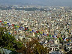
 Northeastern Kathmandu with Gaurishankar in background.


Kathmandu administration
Kathmandu and adjacent cities are composed of neighbourhoods, which are utilized quite extensively and more familiar among locals. However, administratively the city is divided into 32 wards, numbered from 1 to 32. Earlier, there were 35 wards which made it the metropolitan city with the largest number of the wards. Balendra Shah (Balen) has been elected as the new mayor of Kathmandu
_(weic2211a).jpeg&veda=41637)
.jpg&veda=41637)
.jpg&veda=41637)
_Peten_2.jpg&veda=41637)
.jpg&veda=41637)
.jpg&veda=41637)
_by_Rushen_edit.jpg&veda=41637)
.jpg&veda=41637)