

A | B | C | D | E | F | G | H | CH | I | J | K | L | M | N | O | P | Q | R | S | T | U | V | W | X | Y | Z | 0 | 1 | 2 | 3 | 4 | 5 | 6 | 7 | 8 | 9
Tikipunga | |
|---|---|
 | |
 | |
| Coordinates: 35°41′06″S 174°19′43″E / 35.684873°S 174.328543°E | |
| Country | New Zealand |
| City | Whangārei |
| Electoral ward | Whangārei Urban Ward |
| Area | |
| • Land | 575 ha (1,421 acres) |
| Population (June 2023)[2] | |
| • Total | 7,970 |
| Kauri | Totara Parklands | Glenbervie |
| Kamo |
|
|
| Whau Valley | Otangarei |
Tikipunga is one of the biggest suburbs in Whangārei, New Zealand. It is in the north-east part of the city and has the landmark Whangārei Falls nearby.
Demographics
Tikipunga covers 5.75 km2 (2.22 sq mi)[1] and had an estimated population of 7,970 as of June 2023,[2] with a population density of 1,386 people per km2.
| Year | Pop. | ±% p.a. |
|---|---|---|
| 2006 | 5,763 | — |
| 2013 | 5,484 | −0.71% |
| 2018 | 6,906 | +4.72% |
| Source: [3] | ||
Before the 2023 census, the suburb had a smaller boundary, covering 5.48 km2 (2.12 sq mi).[1] Using that boundary, Tikipunga had a population of 6,906 at the 2018 New Zealand census, an increase of 1,422 people (25.9%) since the 2013 census, and an increase of 1,143 people (19.8%) since the 2006 census. There were 2,433 households, comprising 3,213 males and 3,693 females, giving a sex ratio of 0.87 males per female, with 1,662 people (24.1%) aged under 15 years, 1,296 (18.8%) aged 15 to 29, 2,496 (36.1%) aged 30 to 64, and 1,452 (21.0%) aged 65 or older.
Ethnicities were 69.8% European/Pākehā, 41.8% Māori, 6.3% Pacific peoples, 3.3% Asian, and 1.6% other ethnicities. People may identify with more than one ethnicity.
The percentage of people born overseas was 12.9, compared with 27.1% nationally.
Although some people chose not to answer the census's question about religious affiliation, 48.4% had no religion, 36.9% were Christian, 4.2% had Māori religious beliefs, 0.4% were Hindu, 0.1% were Muslim, 0.6% were Buddhist and 1.2% had other religions.
Of those at least 15 years old, 522 (10.0%) people had a bachelor's or higher degree, and 1,416 (27.0%) people had no formal qualifications. 408 people (7.8%) earned over $70,000 compared to 17.2% nationally. The employment status of those at least 15 was that 2,118 (40.4%) people were employed full-time, 606 (11.6%) were part-time, and 315 (6.0%) were unemployed.[3]
| Name | Area (km2) | Population | Density (per km2) | Households | Median age | Median income |
|---|---|---|---|---|---|---|
| Tikipunga North | 2.74 | 3,003 | 1,096 | 1,059 | 36.4 years | $21,900[4] |
| Tikipunga South | 2.74 | 3,903 | 1,424 | 1,374 | 35.4 years | $25,500[5] |
| New Zealand | 37.4 years | $31,800 |
Attractions
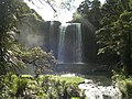
The nearby Whangārei Falls have since the 1940s been in public ownership.[6]
Education
Tikipunga High School is a state coeducational year 7–13 secondary school on Corks Road, with a roll of 347 students as of February 2024.[7][8] The school opened in 1971.
Tikipunga Primary School is a contributing primary (years 1–6) school with a roll of 279 students as of February 2024.[7][9]
Te Kura Kaupapa Maori o Te Rawhiti Roa is a composite (years 1–15) school with a roll of 175 students as of February 2024.[7][10]
All these schools are coeducational.
-
 Whangārei Falls as seen from a walkway over the river.
 -
 Falls from below.
.jpg)

Amenities
The Paramount Plaza shopping centre on Paramount Parade serves the suburb and is anchored by a large Woolworths Supermarket. It contains a service station, several food outlets, a liquor store, a pharmacy, a video store and a medical centre. Nearby is the Tikipunga branch of the Whangārei Libraries. There is also a smaller suburban shopping strip on the corner of Kiripaka Road and Spedding Road.
Notes
- ^ a b c "ArcGIS Web Application". statsnz.maps.arcgis.com. Retrieved 4 April 2024.
- ^ a b "Population estimate tables - NZ.Stat". Statistics New Zealand. Retrieved 25 October 2023.
- ^ a b "Statistical area 1 dataset for 2018 Census". Statistics New Zealand. March 2020. Tikipunga North (106200) and Tikipunga South (106500).
- ^ 2018 Census place summary: Tikipunga North
- ^ 2018 Census place summary: Tikipunga South
- ^ Parkes, W. F. (1992). Guide to Whangarei City and District. p. 11. ISBN 0-473-01639-7.
- ^ a b c "New Zealand Schools Directory". New Zealand Ministry of Education. Retrieved 14 March 2024.
- ^ Education Counts: Tikipunga High School
- ^ Education Counts: Tikipunga Primary School
- ^ Education Counts: Te Kura Kaupapa Maori o Te Rawhiti Roa
External links
Text je dostupný za podmienok Creative Commons Attribution/Share-Alike License 3.0 Unported; prípadne za ďalších podmienok. Podrobnejšie informácie nájdete na stránke Podmienky použitia.
Antropológia
Aplikované vedy
Bibliometria
Dejiny vedy
Encyklopédie
Filozofia vedy
Forenzné vedy
Humanitné vedy
Knižničná veda
Kryogenika
Kryptológia
Kulturológia
Literárna veda
Medzidisciplinárne oblasti
Metódy kvantitatívnej analýzy
Metavedy
Metodika
Text je dostupný za podmienok Creative
Commons Attribution/Share-Alike License 3.0 Unported; prípadne za ďalších
podmienok.
Podrobnejšie informácie nájdete na stránke Podmienky
použitia.
www.astronomia.sk | www.biologia.sk | www.botanika.sk | www.dejiny.sk | www.economy.sk | www.elektrotechnika.sk | www.estetika.sk | www.farmakologia.sk | www.filozofia.sk | Fyzika | www.futurologia.sk | www.genetika.sk | www.chemia.sk | www.lingvistika.sk | www.politologia.sk | www.psychologia.sk | www.sexuologia.sk | www.sociologia.sk | www.veda.sk I www.zoologia.sk