A | B | C | D | E | F | G | H | CH | I | J | K | L | M | N | O | P | Q | R | S | T | U | V | W | X | Y | Z | 0 | 1 | 2 | 3 | 4 | 5 | 6 | 7 | 8 | 9
São Paulo | |
|---|---|
| Municipality of São Paulo Município de São Paulo | |
| Nickname(s): Selva de Pedra (Concrete Jungle); Terra da Garoa (Drizzle Land); Sampa; "Pauliceia Desvairada" (Crazy Pauliceia) | |
| Motto(s): | |
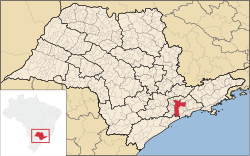 Location in the state of São Paulo | |
| Coordinates: 23°33′S 46°38′W / 23.550°S 46.633°W | |
| Country | Brazil |
| State | São Paulo |
| Historic countries | Kingdom of Portugal United Kingdom of Portugal, Brazil and the Algarves Empire of Brazil |
| Founded | 25 January 1554 |
| Founded by | Manuel da Nóbrega and Joseph of Anchieta |
| Named for | Paul the Apostle |
| Government | |
| • Type | Mayor–council |
| • Body | Municipal Chamber of São Paulo |
| • Mayor | Ricardo Nunes (MDB) |
| • Vice Mayor | Vacant |
| Area | |
| • Municipality | 1,521.11 km2 (587.3039 sq mi) |
| • Urban | 11,698 km2 (4,517 sq mi) |
| • Metro | 7,946.96 km2 (3,068.338 sq mi) |
| • Macrometropolis | 53,369.61 km2 (20,606.12 sq mi) |
| Elevation | 760 m (2,493.4 ft) |
| Population | 12,400,232 |
| • Rank | 1st in South America 1st in Brazil |
| • Density | 8,005.25/km2 (20,733.5/sq mi) |
| • Metro | 22,001,281[1] (Greater São Paulo) |
| • Metro density | 2,714.45/km2 (7,030.4/sq mi) |
| • Macrometropolis | 33,652,991[4] |
| Demonym | Paulistan |
| GDP (nominal) (metro area) | |
| • Year | 2023 |
| • Total | $319.3 billion[5] |
| GDP (PPP, constant 2015 values) (metro area) | |
| • Year | 2023 |
| • Total | $531.3 billion[5] |
| Time zone | UTC−03:00 (BRT) |
| Postal Code (CEP) | 01000-000 |
| Area code | +55 11 |
| HDI (2010) | 0.805 – very high[6] |
| Primary Airport | São Paulo–Guarulhos International Airport |
| Secondary Airports | São Paulo–Congonhas Airport Campo de Marte Airport |
| Interstates | |
| Rapid Transit | São Paulo Metro |
| Commuter Rail | CPTM |
| Website | Capital.sp.gov.br |
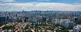
São Paulo (/ˌsaʊ ˈpaʊloʊ/, Portuguese: [sɐ̃w ˈpawlu] ; Portuguese for 'Saint Paul') is the most populous city in Brazil and the capital of the state of São Paulo. Listed by the GaWC as an alpha global city, São Paulo is the most populous city in the world outside of Asia and the world's 20th-largest city proper by population. Additionally, São Paulo is the largest Portuguese-speaking city in the world. It exerts strong international influences in commerce, finance, arts, and entertainment.[7] The city's name honors the Apostle, Saint Paul of Tarsus. The city's metropolitan area, the Greater São Paulo, ranks as the most populous in Brazil and the 12th-most-populous on Earth. The process of conurbation between the metropolitan areas around the Greater São Paulo (Campinas, Santos, Jundiaí, Sorocaba and São José dos Campos) created the São Paulo Macrometropolis,[8] a megalopolis with more than 30 million inhabitants, one of the most populous urban agglomerations in the world.[9]
São Paulo has the largest economy by GDP of the cities of Latin America,[10] and the 23rd largest city GDP in the world,[11] representing 10.7% of the Brazilian GDP[12] and 36% of the goods and services produced in the state of São Paulo. The city is home to the São Paulo Stock Exchange, as well as 63% of established multinationals in Brazil.[13] Paulista Avenue is the economic core of São Paulo.
The city was responsible for 28% of the national scientific production in 2005, as measured by the number of science papers published in journals.[14]
The metropolis is also home to several of the tallest skyscrapers in Brazil, including the Mirante do Vale, Edifício Itália, Banespa, North Tower and many others. The city has cultural, economic and political influence nationally and internationally. It is home to monuments, parks and museums such as the Latin American Memorial, the Ibirapuera Park, UNASP São Paulo Memory Center, Museum of Ipiranga, São Paulo Museum of Art, and the Museum of the Portuguese Language. Its main university, the University of São Paulo, is considered the best in Brazil and Latin America.[15][16] The city holds events like the São Paulo Jazz Festival, São Paulo Art Biennial, the Brazilian Grand Prix, São Paulo Fashion Week, the ATP Brasil Open, the Brasil Game Show and the Comic Con Experience. São Paulo's LGBT Pride parade ranks second only to the New York City Pride March among the largest LGBT Pride parades in the world.[17][18]
São Paulo is a cosmopolitan, melting pot city, home to the largest Arab, Italian, and Japanese diasporas, with examples including ethnic neighborhoods of Bixiga, Bom Retiro, and Liberdade. In 2016, inhabitants of the city were native to over 200 countries.[19] People from the city are known as paulistanos, while paulistas designates anyone from the state, including the paulistanos. The city's Latin motto, which it has shared with the battleship and the aircraft carrier named after it, is Non ducor, duco, which translates as "I am not led, I lead."[20] The city, which is also colloquially known as Sampa, Selva de Pedra (Jungle of Stone)[21] or Terra da Garoa (Land of Drizzle), is known for its unreliable weather, the size of its helicopter fleet, its architecture, gastronomy, severe traffic congestion and skyscrapers. São Paulo was one of the host cities of the 1950 and 2014 FIFA World Cups. Additionally, the city hosted the IV Pan American Games, Miss Universe 2011, and the São Paulo Indy 300.
History
Pre-colonial period
Portuguese Empire 1554–1815
United Kingdom of Portugal, Brazil and the Algarves 1815–1822
Empire of Brazil 1822–1889
Republic of Brazil 1889–present
The region of modern-day São Paulo, then known as Piratininga plains around the Tietê River, was inhabited by the Tupi people, such as the Tupiniquim, Guaianás, and Guarani. Other tribes also lived in areas that today form the metropolitan region.[22]
The region was divided in Caciquedoms (chiefdoms) at the time of encounter with the Europeans.[23] The most notable cacique was Tibiriçá, known for his support for the Portuguese and other European colonists. Among the many indigenous names of places, rivers, neighborhoods, etc., that survive today are Tietê, Ipiranga, Tamanduateí, Anhangabaú, Piratininga, Itaquaquecetuba, Cotia, Itapevi, Barueri, Embu-Guaçu, etc.
Colonial period
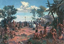
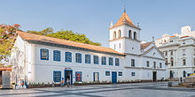
The Portuguese village of São Paulo dos Campos de Piratininga was marked by the founding of the Colégio de São Paulo de Piratininga on 25 January 1554. The Jesuit college of twelve priests included Manuel da Nóbrega and Spanish priest José de Anchieta. They built a mission on top of a steep hill between the Anhangabaú and Tamanduateí rivers.[24]
They first had a small structure built of rammed earth, made by Native Indian workers in their traditional style. The priests wanted to evangelize these Indians who lived in the Plateau region of Piratininga and convert them to Christianity. The site was separated from the coast by the Serra do Mar mountain range, called "Serra Paranapiacaba" by the Indians.
The college was named for a Christian saint and its founding on the feast day of the celebration of the conversion of the Apostle Paul of Tarsus. Father José de Anchieta wrote this account in a letter to the Society of Jesus:
The settlement of the region's Courtyard of the College began in 1560. During the visit of Mem de Sá, Governor-General of Brazil, the Captaincy of São Vicente, he ordered the transfer of the population of the Village of São Bernardo do Campo to the vicinity of the college. It was then named "College of St. Paul of the Piratininga". The new location was on a steep hill adjacent to a large wetland, the Várzea do Carmo. It offered better protection from attacks by local Indian groups. It was renamed Vila de São Paulo, belonging to the Captaincy of São Vicente.
For the next two centuries, São Paulo developed as a poor and isolated village that survived largely through the cultivation of subsistence crops by the labor of natives. For a long time, São Paulo was the only village in Brazil's interior, as travel was too difficult for many to reach the area. Mem de Sá forbade colonists to use the Caminho do Piraquê (Piraquê Path) and today known as Piaçaguera, because of frequent Indian raids along it.
On 22 March 1681, Luís Álvares de Castro, the Second Marquis de Cascais and donee of the Captaincy of São Vicente, moved the capital to the village of São Paulo (see Timeline of São Paulo), designating it the "Head of the captaincy". The new capital was established on 23 April 1683, with public celebrations.
The Bandeirantes

In the 17th century, São Paulo was one of the poorest regions of the Portuguese colony. It was also the center of interior colonial development. Because they were extremely poor, the Paulistas could not afford to buy African slaves, as did other Portuguese colonists. The discovery of gold in the region of Minas Gerais, in the 1690s, brought attention and new settlers to São Paulo. The Captaincy of São Paulo and Minas de Ouro (see Captaincies of Brazil) was created on 3 November 1709, when the Portuguese crown purchased the Captaincies of São Paulo and Santo Amaro from the former grantees.[25]
Conveniently located in the country, up the steep Serra do Mar escarpment/mountain range when traveling from Santos, while also not too far from the coastline, São Paulo became a safe place to stay for tired travelers. The town became a center for the bandeirantes, intrepid invaders who marched into unknown lands in search for gold, diamonds, precious stones, and Indians to enslave. The bandeirantes, which could be translated as "flag-bearers" or "flag-followers", organized excursions into the land with the primary purpose of profit and the expansion of territory for the Portuguese crown. Trade grew from the local markets and from providing food and accommodation for explorers. The bandeirantes eventually became politically powerful as a group, and forced the expulsion of the Jesuits from the city of São Paulo in 1640. The two groups had frequently come into conflict because of the Jesuits' opposition to the domestic slave trade in Indians.

On 11 July 1711, the town of São Paulo was elevated to city status. Around the 1720s, gold was found by the pioneers in the regions near what are now Cuiabá and Goiânia. The Portuguese expanded their Brazilian territory beyond the Tordesillas Line to incorporate the gold regions. When the gold ran out in the late 18th century, São Paulo shifted to growing sugar cane. Cultivation of this commodity crop spread through the interior of the Captaincy. The sugar was exported through the Port of Santos. At that time, the first modern highway between São Paulo and the coast was constructed and named the Calçada do Lorena ("Lorena's settway"). Nowadays, the estate that is home to the Governor of the State of São Paulo, in the city of São Paulo, is called the Palácio dos Bandeirantes (Bandeirantes Palace), in the neighborhood of Morumbi.
Imperial period


After Brazil became independent from Portugal in 1822, as declared by Emperor Pedro I where the Monument to the Independence of Brazil is located, he named São Paulo as an Imperial City. In 1827, a law school was founded at the Convent of São Francisco, today part of the University of São Paulo. The influx of students and teachers gave a new impetus to the city's growth, thanks to which the city became the Imperial City and Borough of Students of St. Paul of Piratininga.
The expansion of coffee production was a major factor in the growth of São Paulo, as it became the region's chief export crop and yielded good revenue. It was cultivated initially in the Paraíba Valley region in the East of the State of São Paulo, and later on in the regions of Campinas, Rio Claro, São Carlos and Ribeirão Preto.
From 1869 onward, São Paulo was connected to the port of Santos by the Estrada de Ferro Santos-Jundiaí (Santos-Jundiaí Railroad), nicknamed The Lady. In the late 19th century, several other railroads connected the interior to the state capital. São Paulo became the point of convergence of all railroads from the interior of the state. Coffee was the economic engine for major economic and population growth in the State of São Paulo.
In 1888, the "Golden Law" (Lei Áurea) was sanctioned by Isabel, Princess Imperial of Brazil, abolishing the institution of slavery in Brazil. Slaves were the main source of labor in the coffee plantations until then. As a consequence of this law, and following governmental stimulus towards the increase of immigration, the province began to receive a large number of immigrants, largely Italians, Japanese and Portuguese peasants, many of whom settled in the capital. The region's first industries also began to emerge, providing jobs to the newcomers, especially those who had to learn Portuguese.
Old Republican period
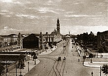

By the time Brazil became a republic on 15 November 1889, coffee exports were still an important part of São Paulo's economy. São Paulo grew strong in the national political scene, taking turns with the also rich state of Minas Gerais in electing Brazilian presidents, an alliance that became known as "coffee and milk", given that Minas Gerais was famous for its dairy production. During this period, São Paulo went from regional center to national metropolis, becoming industrialized and reaching its first million inhabitants in 1928. Its greatest growth in this period was relative in the 1890s when it doubled its population. The height of the coffee period is represented by the construction of the second Luz Station (the present building) at the end of the 19th century and by the Paulista Avenue in 1900, where they built many mansions.[26]
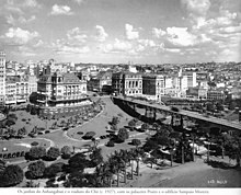
Industrialization was the economic cycle that followed the coffee plantation model. By the hands of some industrious families, including many immigrants of Italian and Jewish origin, factories began to arise and São Paulo became known for its smoky, foggy air. The cultural scene followed modernist and naturalist tendencies in fashion at the beginning of the 20th century. Some examples of notable modernist artists are poets Mário de Andrade and Oswald de Andrade, artists Anita Malfatti, Tarsila do Amaral and Lasar Segall, and sculptor Victor Brecheret. The Modern Art Week of 1922 that took place at the Theatro Municipal was an event marked by avant-garde ideas and works of art. In 1929, São Paulo won its first skyscraper, the Martinelli Building.[26]
The modifications made in the city by Antônio da Silva Prado, Baron of Duprat and Washington Luís, who governed from 1899 to 1919, contributed to the climate development of the city; some scholars consider that the entire city was demolished and rebuilt at that time. São Paulo's main economic activities derive from the services industry – factories are since long gone, and in came financial services institutions, law firms, consulting firms. Old factory buildings and warehouses still dot the landscape in neighborhoods such as Barra Funda and Brás. Some cities around São Paulo, such as Diadema, São Bernardo do Campo, Santo André, and Cubatão are still heavily industrialized to the present day, with factories producing from cosmetics to chemicals to automobiles.
In 1924 the city was the stage of the São Paulo Revolt, an armed conflict fought in working-class neighborhoods near the center of São Paulo that lasted 23 days, from 5 to 28 July, leaving hundreds dead and thousands injured. The confrontation between the federal troops of president Artur Bernardes against rebels of the Brazilian Army and the Public Force of São Paulo was classified by the federal government as a conspiracy, a mutiny and a "revolt against the Fatherland, without foundation, headed by disorderly members of the Brazilian Army".[27] To face the rebels, the federal government launched an indiscriminate artillery bombardment against the city, which affected mostly civilian targets; as a result of the bombing, a third of São Paulo's 700,000 inhabitants fled the city. The revolt has been described as "the largest urban conflict in the history of Brazil".[28]
Revolution of 1932 and contemporary era


In 1932, São Paulo mobilized in its largest civic movement: the Constitutionalist Revolution, when the entire population engaged in the war against the "Provisional Government" of Getúlio Vargas. In 1934, with the reunion of some faculties created in the 19th century, the University of São Paulo (USP) was founded, today the largest in Brazil.[29][30]
The first major project for industrial installation in the city was the industrial complex of Indústrias Matarazzo in Barra Funda. In the 1930s, the Jafet brothers, operating in the fabric business, Rodolfo Crespi, the Puglisi Carbone brothers and the Klabin family, who would found the first large cellulose industry in Brazil, the Klabin.[31] Another major industrial boom occurred during the Second World War, due to the crisis in coffee farming in the 1930s and restrictions on international trade during the war, which resulted in the city having a very high economic growth rate that remained high in the post-war period.[32]
In 1947, São Paulo gained its first paved highway: the Via Anchieta (built on the old route of José de Anchieta), connecting the capital to the coast of São Paulo. In the 1950s, São Paulo was known as "the city that never stop" and as "the fastest growing city in the world".[32] São Paulo held a large celebration, in 1954, of the "Fourth Centenary" of the city's founding, when the Ibirapuera Park was inaugurated, many historical books are released and the source of the Tietê River in Salesópolis is discovered. With the transfer of part of the city's financial center, which was located in the historic center (in the region called the "Historic Triangle"), to Paulista Avenue, its mansions were, for the most part, replaced by large buildings.[32]

In the period from the 1930s to the 1960s, the great entrepreneurs of São Paulo's development were mayor Francisco Prestes Maia and the governor Ademar de Barros, who was also mayor of São Paulo between 1957 and 1961. Prestes Maia designed and implemented, in the 1930s, the "Avenue Plan for the City of São Paulo", which revolutionized São Paulo's traffic.[33] These two rulers are also responsible for the two biggest urban interventions, after the Avenues Plan, which changed São Paulo: the rectification of the Tietê river with the construction of its banks and the São Paulo Metro: on February 13, 1963, governor Ademar de Barros and mayor Prestes Maia created study commissions (state and municipal) to prepare the basic project for the São Paulo Metro, and allocated their first funds to the Metro.[34] At the beginning of the 1960s, São Paulo already had four million inhabitants. Construction of the metro began in 1968, under the administration of Mayor José Vicente de Faria Lima, and the commercial operation started on September 14, 1974. In 2016 the system had a network 71.5 km long and 64 stations spread across five lines. That year, 1.1 billion passengers were transported by the system.[35]
At the end of the 20th century and beginning of the 21st century, São Paulo became the main financial center in South America and one of the most populous cities in the world. As the most influential Brazilian city on the global stage, São Paulo is currently classified as an alpha global city.[7] The metropolis has one of the largest GDP in the world, representing, alone, 11% of all Brazilian GDP,[12] and is also responsible for one third of the Brazilian scientific production.[36]
Geography

São Paulo is the capital of the most populous state in Brazil, São Paulo, located at latitude 23°33'01'' south and longitude 46°38'02'' west. The total area of the municipality is 1,521.11 square kilometres (587.30 sq mi), according to the Brazilian Institute of Geography and Statistics (IBGE), being the ninth largest in the state in terms of territorial extension.[38] Of the entire area of the municipality, 949,611 square kilometres (366,647 sq mi) are urban areas (2015), being the largest urban area in the country.[39]
The city is on a plateau placed beyond the Serra do Mar (Portuguese for "Sea Range" or "Coastal Range"), itself a component of the vast region known as the Brazilian Highlands, with an average elevation of around 799 meters (2,621 ft) above sea level, although being at a distance of only about 70 kilometers (43 mi) from the Atlantic Ocean. The distance is covered by two highways, the Anchieta and the Imigrantes, (see "Transportation" below) that roll down the range, leading to the port city of Santos and the beach resort of Guarujá. Rolling terrain prevails within the urbanized areas of São Paulo except in its northern area, where the Serra da Cantareira Range reaches a higher elevation and a sizable remnant of the Atlantic Rain Forest. The region is seismically stable and no significant activity has ever been recorded.[40]
Hydrography
The Tietê River and its tributary, the Pinheiros River, were once important sources of fresh water and leisure for São Paulo. However, heavy industrial effluents and wastewater discharges in the later 20th century caused the rivers to become heavily polluted. A substantial clean-up program for both rivers is underway.[41][42] Neither river is navigable in the stretch that flows through the city, although water transportation becomes increasingly important on the Tietê river further downstream (near river Paraná), as the river is part of the River Plate basin.[43]
No large natural lakes exist in the region, but the Billings and Guarapiranga reservoirs in the city's southern outskirts are used for power generation, water storage and leisure activities, such as sailing. The original flora consisted mainly of broadleaf evergreens. Non-native species are common, as the mild climate and abundant rainfall permit a multitude of tropical, subtropical and temperate plants to be cultivated, especially the ubiquitous eucalyptus.[44]
The north of the municipality contains part of the 7,917 hectares (19,560 acres) Cantareira State Park, created in 1962, which protects a large part of the metropolitan São Paulo water supply.[45] In 2015, São Paulo experienced a major drought, which led several cities in the state to start a rationing system.[46]
Parks and biodiversity
São Paulo is located in an ecotone area between 3 biomes: mixed ombrophilous forest, dense ombrophilous forest and cerrado; the latter had some plant species native to the pampas in the city. There were several species typical of both biomes, among them we can mention: araucarias, pitangueiras, cambucís, ipês, jabuticabeiras, queen palms, muricís-do-campo, etc.[47]
In 2010, São Paulo had 62 municipal and state parks,[48] such as the Cantareira State Park, part of the São Paulo Green Belt Biosphere Reserve and home to one of the largest urban forests on the planet with 7,900 hectares (20,000 acres) of extension,[49] the Fontes do Ipiranga State Park, the Ibirapuera Park, the Tietê Ecological Park, the Capivari-Monos Environmental Protection Area, the Serra do Mar State Park, Villa-Lobos State Park, People's Park, and the Jaraguá State Park, listed as a World Heritage Site by UNESCO in 1994.[50]
In 2009, São Paulo had 2,300 hectares (5,700 acres) of green area, less than 1.5% of the city's area[51] and below the 12 square metres (130 sq ft) per inhabitant recommended by the World Health Organization (WHO).[52] About 21% of the municipality's area is covered by green areas, including ecological reserves (2010 data).[53][54]
In the municipality it is possible to observe forest birds that usually appear in the spring, due to the belt of native forest that still surrounds the metropolitan region. Species such as the rufous-bellied thrush, golden-chevroned tanager, great kiskadee and hummingbird are the most common. Despite the intense pollution, the main rivers of the city, the Tietê and the Pinheiros, shelter several species of animals such as capybaras, hawks, southern lapwings, herons and nutrias. Other species found in the municipality are the gray brocket, howler monkey, green-billed toucan and the Amazonian umbrellabird.[55]
Environment
Air pollution in some districts of the city exceeds local standards, mainly due to car traffic.[56] The World Health Organization (WHO) sets a limit of 20 micrograms of particulate matter per cubic meter of air as a safe annual average. In an assessment carried out by the WHO among over a thousand cities around the world in 2011, the city of São Paulo was ranked 268th among the most polluted, with an average rate of 38 micrograms per cubic meter, a rate well above the limit imposed by the organization, but lower than in other Brazilian cities, such as Rio de Janeiro (64 micrograms per cubic meter).[57] A 2013 study found that air pollution in the city causes more deaths than traffic accidents.[58][59]
The stretch of the Tietê River that runs through the city is the most polluted river in Brazil.[60] In 1992, the Tietê Project began, with the aim to clean up the river by 2005. 8.8 billion reais was spent on the failed project.[61] In 2019, the Novo Rio Pinheiros Project began, under the administration of João Doria, with the aim to reduce sewage discharged into the Tietê's tributary, the Pinheiros River.[62][63]
The problem of balanced water supply for the city - and for the metropolis, in general - is also a worrying issue: São Paulo has few sources of water in its own perimeter, having to seek it in distant hydrographic basins. The problem of water pollution is also aggravated by the irregular occupation of watershed areas, caused by urban expansion, driven by the difficulty of access to land and housing in central areas by the low-income population[64] and associated with real estate speculation and precariousness in new subdivisions. With this, there is also an overvaluation of individual transport over public transport – leading to the current rate of more than one vehicle for every two inhabitants and aggravating the problem of environmental pollution.[65]
Climate

According to the Köppen classification, the city has a humid subtropical climate (Cfa, bordering on Cwa).[67][68] In summer (January through March), the mean low temperature is about 19 °C (66 °F) and the mean high temperatures is near 28 °C (82 °F). In winter, temperatures tend to range between 12 and 22 °C (54 and 72 °F). The record high temperature was 37.8 °C (100.0 °F) on 17 October 2014[69] and the lowest −3.2 °C (26.2 °F) on 25 June 1918.[70][71] The Tropic of Capricorn, at about 23°27' S, passes through north of São Paulo and roughly marks the boundary between the tropical and temperate areas of South America. Because of its elevation, however, São Paulo experiences a more temperate climate.[72] The summer is warm and rainy. Autumn and spring are transitional seasons. Winter is mild, but still the coldest season, with cloudiness around town and frequent polar air masses. Frosts occur sporadically in regions further away from the center, in some winters throughout the city.[73]
Rainfall is abundant, annually averaging 1,454 millimeters (57.2 in).[74] It is especially common in the warmer months averaging 219 millimeters (8.6 in) and decreases in winter, averaging 47 millimeters (1.9 in). Neither São Paulo nor the nearby coast has ever been hit by a tropical cyclone and tornadic activity is uncommon. During late winter, especially August, the city experiences the phenomenon known as "veranico" or "verãozinho" ("little summer"), which consists of hot and dry weather, sometimes reaching temperatures well above 28 °C (82 °F). On the other hand, relatively cool days during summer are fairly common when persistent winds blow from the ocean. On such occasions daily high temperatures may not surpass 20 °C (68 °F), accompanied by lows often below 15 °C (59 °F), however, summer can be extremely hot when a heat wave hits the city followed by temperatures around 34 °C (93 °F), but in places with greater skyscraper density and less tree cover, the temperature can feel like 39 °C (102 °F), as on Paulista Avenue for example. In the summer of 2014, São Paulo was affected by a heat wave that lasted for almost 4 weeks with highs above 30 °C (86 °F), peaking on 36 °C (97 °F). Secondary to deforestation, groundwater pollution, and climate change, São Paulo is increasingly susceptible to drought and water shortages.[75]
| Climate data for São Paulo (Mirante de Santana, 1991–2020, extremes 1887–present) | |||||||||||||
|---|---|---|---|---|---|---|---|---|---|---|---|---|---|
| Month | Jan | Feb | Mar | Apr | May | Jun | Jul | Aug | Sep | Oct | Nov | Dec | Year |
| Record high °C (°F) | 37.0 (98.6) |
35.9 (96.6) |
34.3 (93.7) |
33.4 (92.1) |
31.7 (89.1) |
28.8 (83.8) |
30.2 (86.4) |
33.0 (91.4) |
35.7 (96.3) |
37.8 (100.0) |
37.7 (99.9) |
35.6 (96.1) |
37.8 (100.0) |
| Mean daily maximum °C (°F) | 28.6 (83.5) |
29.0 (84.2) |
28.0 (82.4) |
26.6 (79.9) |
23.4 (74.1) |
22.9 (73.2) |
22.9 (73.2) |
24.5 (76.1) |
25.2 (77.4) |
26.5 (79.7) |
26.9 (80.4) |
28.3 (82.9) |
26.1 (79.0) |
| Daily mean °C (°F) | 23.1 (73.6) |
23.5 (74.3) |
22.5 (72.5) |
21.2 (70.2) |
18.4 (65.1) |
17.5 (63.5) |
17.2 (63.0) |
18.1 (64.6) |
19.1 (66.4) |
20.5 (68.9) |
21.2 (70.2) |
22.6 (72.7) |
20.4 (68.7) |
| Mean daily minimum °C (°F) | 19.4 (66.9) |
19.6 (67.3) |
18.9 (66.0) |
17.5 (63.5) |
14.7 (58.5) |
Zdroj:https://en.wikipedia.org?pojem=São_Paulo,_São_Paulo||||||||

